Strong To Severe Storms Possible Today; Cooler Air To End 2019
Today
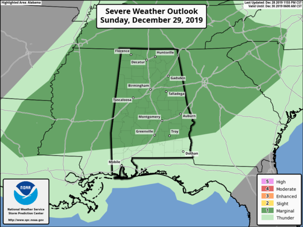
The Storm Prediction Center continues to have all of Central Alabama in a Marginal Risk for severe storms throughout the entire day on Sunday. Isolated damaging winds up to 60 MPH and a brief tornado may be possible. The main window for the potential of stronger to severe storms will be from noon today through midnight tonight.
We’ll start off the day with scattered showers possible mainly over the western and west-central parts of the area with those chances increasing throughout the day as we’ll have a couple of waves of storms move in later on. Rain and storms will be likely at times, but we will see a few quiet moments throughout the day as well. Afternoon highs will max out in the lower to mid-70s with dewpoints in the mid-60s.
We could see a few storms form well in advance of the waves of storms that could potentially become strong, but we believe that the first wave of the main action will move into the western parts of Central Alabama around 2-4 pm. This may turn out to be a ragged line of supercellular thunderstorms that may possibly become stronger to severe with a low-end threat of a brief tornado or isolated damaging winds.
The second wave will enter the western parts of Central Alabama around 7-9 pm as a squall line. This is where we would see the higher helicity and wind shear values, but the only question is will we have enough juice in the atmosphere to help these storms to become strong to severe.
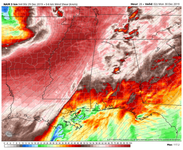
Shear at 8:00 pm (00z NAM-3k).
Shear values out ahead and along this line of storms look to top out in the 62-66 knots range… more than enough to support spin as the air parcels rise. We will also have plenty of helicity along and ahead of the line reaching as high as 500 m2/s2… more than enough to support rotating updrafts.
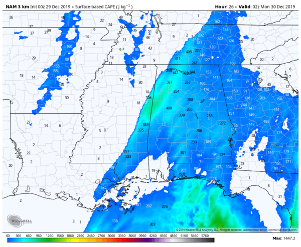
Surface-based instability at 8:00 pm (00z NAM-3k).
Surface-based instability will be the questionable ingredient, but we have to remember that it doesn’t take much instability to have severe storms during these winter-type systems. This run shows values reaching as high as 900 J/kg, which is more than enough to support severe storms.
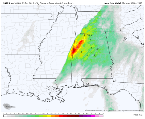
STP at 8:00 pm (00z NAM-3k).
With all of those parameters added together, we are seeing Significant Tornado Parameter values now maxing out close to 4.0 over parts of Pickens County, along with a good bit of 2.8-3.6 values immediately surrounding that and extending northeastward into parts of Lamar, Fayette, Marion, and Winston counties.
As said earlier, instability may be the limiting factor as the amount of cloud cover and pre-frontal rain may hamper the destabilization of the atmosphere. If we have any extra sunshine, instability values will be able to rise and the potential will be there for storms to become more active. We’ll have updates throughout the day, especially after I finish up on a conference call with NWS Birmingham at 10:00 am.
Monday
The cold front will finally move out of the southeastern parts of the area on Monday morning, which will leave us with cooler and drier air across Central Alabama. Skies will end up mainly sunny by before sunset with highs reaching the mid-50s to the lower 60s.
New Year’s Eve
A ridge of high pressure will be moving in our direction from the west which will keep us cool and dry for the final day of the decade. We’ll have maximum sunshine throughout the daylight hours and clear skies through midnight. Highs will be in the 50s across the area and dropping into the mid to upper 30s around midnight.
Happy New Years
Skies on the first day of the 2020s will be partly cloudy to start, but those clouds will be on the increase throughout the day. We look to stay dry and cool with afternoon highs reaching the 50s.
Thursday
On Thursday, moisture will be flowing up into Central Alabama from the southwest with the next disturbance which looks to bring heavy rain and maybe a few thunderstorms. We’ll have to watch and see if this system evolves into where we may have a few stronger storms possible over the next couple of days. At this point, it doesn’t scream severe weather, but it does show heavy rain at times. A few flash flooding issues may occur in poor drainage areas as totals are projected to be in the 1/2 inch to 2-inch range from southeast to the west and northwest. Highs will be in the mid-50s to the mid-60s.
Friday
Rain will finally push out of the area before midday on Friday, but we could see a few wrap-around light rain showers or drizzle move across the northern parts of Central Alabama during the afternoon hours. Highs will be in the upper 50s to the mid-60s.
Next Weekend
We look to stay dry throughout the Central Alabama weekend as we should have plenty of sunshine on both days. Saturday’s highs look to be in the upper 50s to the lower 60s and staying the same on Sunday.
Category: Alabama's Weather, ALL POSTS, Severe Weather, Weather Xtreme Videos
About the Author (Author Profile)
Scott Martin is an operational meteorologist, professional graphic artist, musician, husband, and father. Not only is Scott a member of the National Weather Association, but he is also the Central Alabama Chapter of the NWA president. Scott is also the co-founder of Racecast Weather, which provides forecasts for many racing series across the USA. He also supplies forecasts for the BassMaster Elite Series events including the BassMaster Classic.Subscribe
If you enjoyed this article, subscribe to receive more just like it.


