

Mild, Unsettled Weather For Alabama This Week
RADAR CHECK: Showers and thunderstorms are over much of Alabama this morning south of I-59 (Tuscaloosa to Birmingham to Gadsden), along and south of a stalled front draped over the state. The front will move slowly northward as a warm front over the next 24 hours, and we expect periods of rain along with a few thunderstorms statewide through tonight. Some heavy rain is possible, and localized flooding issues could develop as the ground is completely saturated. Also, there is a low end “marginal risk” (level 1/5) for a few severe thunderstorms over the northern quarter of the state this afternoon and tonight; a few storms there could produce hail and gusty winds. But, the overall threat level is low.
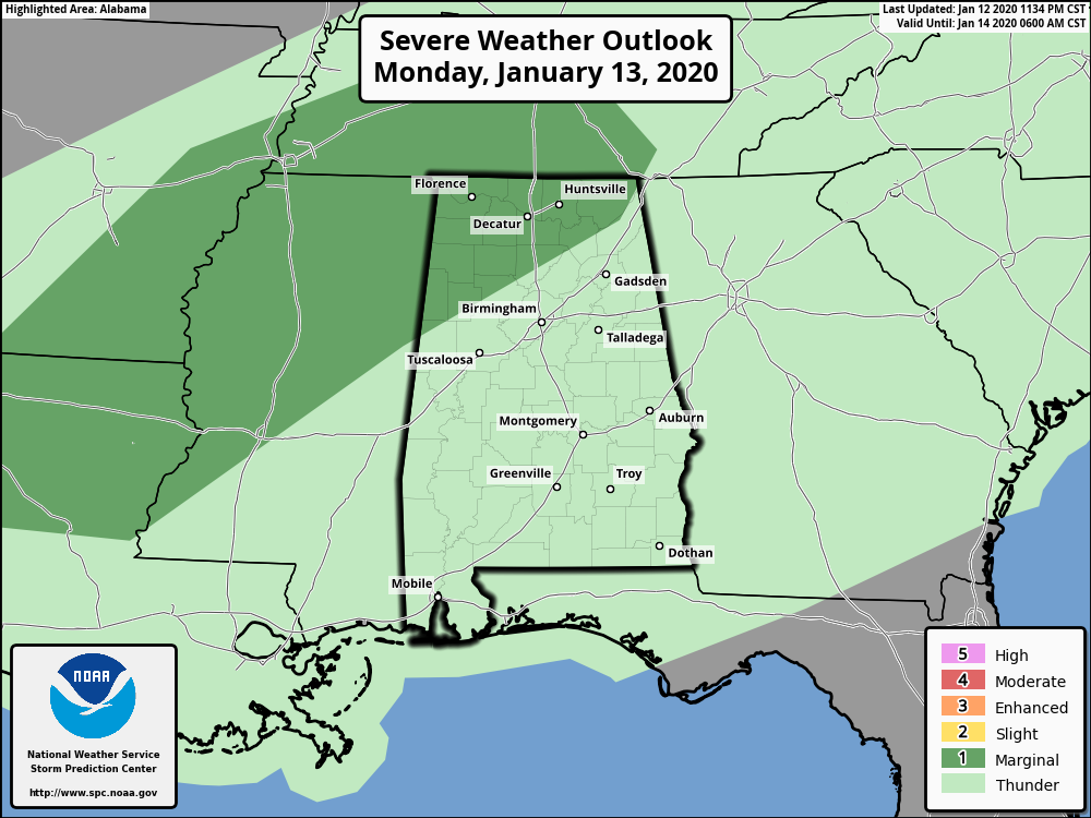
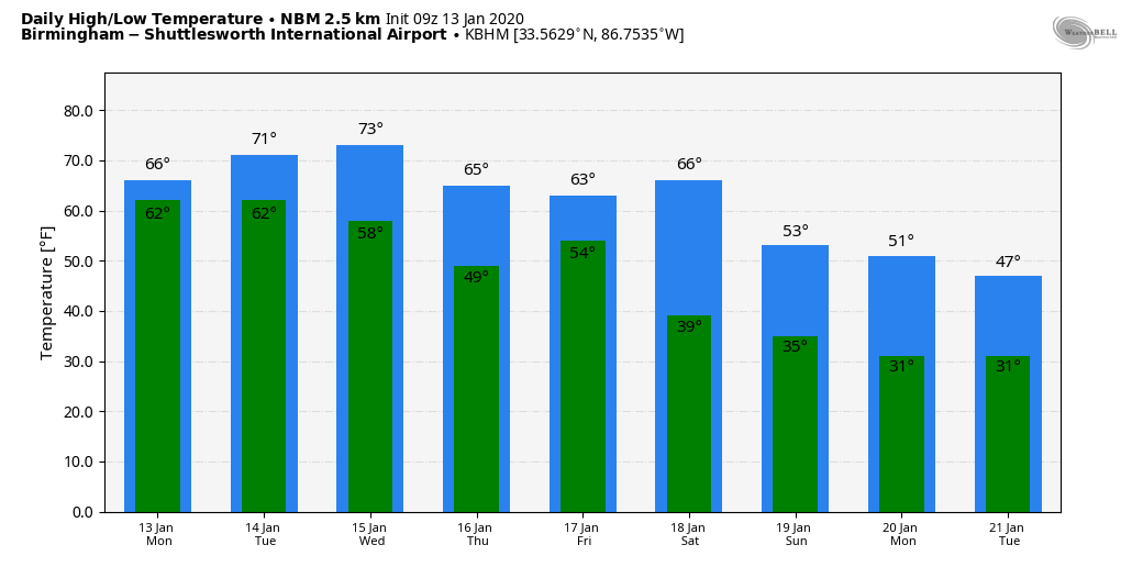
Look for a high today well up in the 60s; 70s are possible over parts of South Alabama as the unseasonably mild weather continues.
TOMORROW: Very moist air remains in place… we will forecast a mostly cloudy sky with occasional showers and thunderstorms. Once again the rain could be heavy in spots, and a few flooding problems are possible during the day. And, strong storms could form as well; SPC has about the northern quarter of the state in a “marginal risk” (level 1/5).
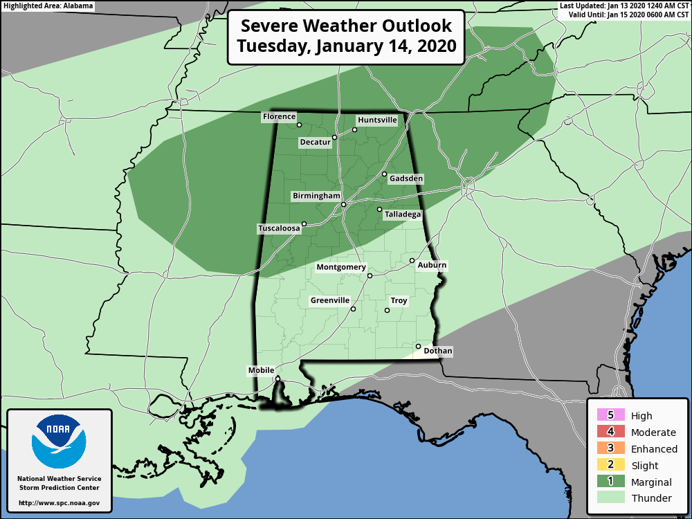
A few of the heavier storms tomorrow could produce small hail and gusty winds, but once again this is a low end threat. The weather stays mild; we project a high tomorrow in the low 70s for most places.
WEDNESDAY THROUGH FRIDAY: Rain is likely at times Wednesday, but drier air will push down into the northern half of the state Thursday and Friday; the best chance of showers on these two days will be over the southern half of the state. Highs will remain in the 60s.
THE ALABAMA WEEKEND: A cold front will bring a chance of showers and thunderstorms to the state Saturday; for now the severe weather risk looks low. Then, cooler, drier air arrives Sunday with rain-free weather statewide. The high Saturday will be in the 60s, dropping to near 50 on Sunday.
NEXT WEEK: A pattern change will keep colder air in place across the state; North Alabama could hold in the 40s on a number of days. Any rain should be confined to the southern counties of the state… See the Weather Xtreme video for maps, graphics, and more details.
SATURDAY’S STORM SURVEYS: NWS survey teams have identified 5 tornadoes in Alabama so far from Saturday severe storm event.
*Pickens County (near Carrollton) EF-2
*Marshall County (Union Grove) EF-2
*Barbour County (southwest of Eufaula) EF-1
*Cullman/Marshall Counties (near Joppa) EF-1
*Cullman County (Holly Pond) EF-0
Thunderstorm wind damage was widespread across Alabama; around 200,000 Alabama Power customers lost service at some point over the weekend. Hundreds of trees were taken down.
ON THIS DATE IN 1982: Alabama was in the midst of a crippling ice storm. Freezing rain created a thick coating on all exposed objects. Trees snapped, pulling down power lines and putting as many as 750,000 Alabamians in the dark. The sound of tree limbs snapping under the weight of the ice was like shotguns.When it was all said and done, twenty Alabamians were dead and another 300 injured and damage totaled $78 million.
BEACH FORECAST: Click here to see the AlabamaWx Beach Forecast Center page.
WEATHER BRAINS: Don’t forget you can listen to our weekly 90 minute show anytime on your favorite podcast app. This is the show all about weather featuring many familiar voices, including our meteorologists here at ABC 33/40.
CONNECT: You can find me on all of the major social networks…
Facebook
Twitter
Instagram
Pinterest
Snapchat: spannwx
Look for the next Weather Xtreme video here by 4:00 this afternoon… enjoy the day!
Category: Alabama's Weather, ALL POSTS, Weather Xtreme Videos
About the Author (Author Profile)
James Spann is one of the most recognized and trusted television meteorologists in the industry. He holds the AMS CCM designation and television seals from the AMS and NWA. He is a past winner of the Broadcast Meteorologist of the Year from both professional organizations.Subscribe
If you enjoyed this article, subscribe to receive more just like it.


