Severe Storms Possible Late Tomorrow/Tomorrow Night
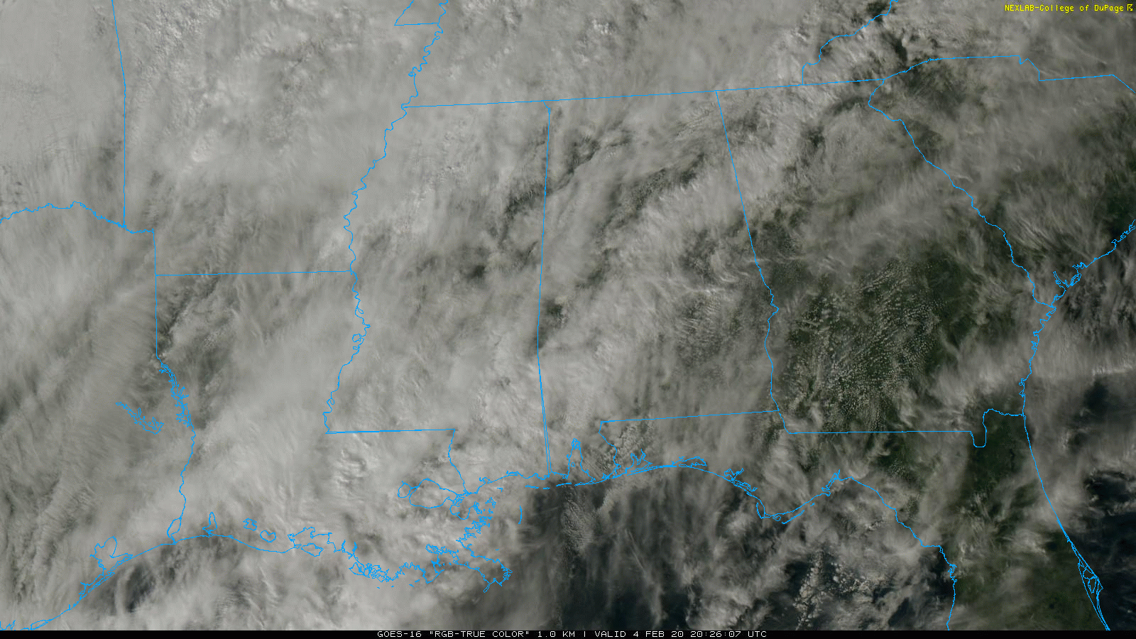
RADAR CHECK: Some light rain is falling across parts of East and Central Alabama this afternoon, otherwise the sky is mostly cloudy with temperatures kn the 60s and low 70s. We will maintain the chance of a few passing showers tonight; temperatures will hold in the 60s.
SEVERE STORMS POSSIBLE LATE TOMORROW/TOMORROW NIGHT: SPC has expanded the “slight risk” (level 2/5) of severe thunderstorms to include much of the state tomorrow and tomorrow night… there is a “marginal risk (level 1/5) for Far East Alabama.
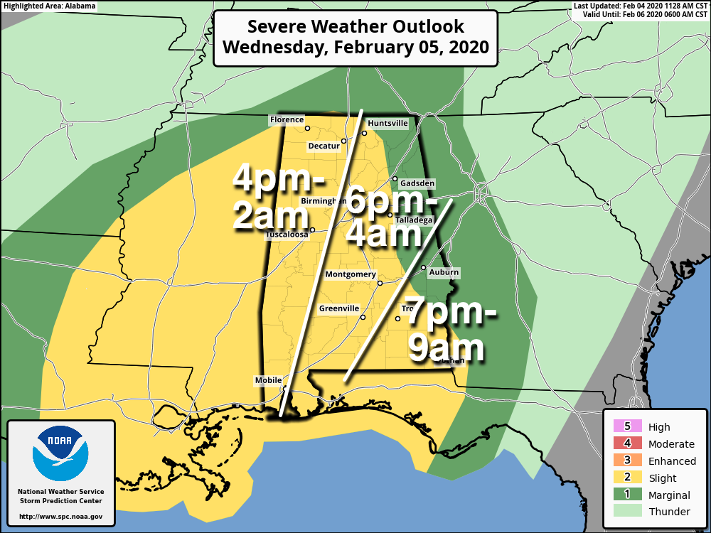
The key to the severe weather threat is the degree of instability available. The thermodynamic environment remains somewhat questionable; a number of the high resolution models show a large mass of rain moving up from the south during the day tomorrow, which would keep instability values low and limit the severe weather potential. However, if the large rain mass doesn’t materialize, the threat will be more significant.
TIMING: The main window for severe storms across Alabama will come from 4:00 p.m. tomorrow through 6:00 a.m. Thursday. The risk of severe storms will persist across Southeast Alabama (places like Dothan and Ozark) through 9:00 a.m. Thursday.
THREATS: Heavier storms will be capable of producing small hail, strong winds, and a few tornadoes.
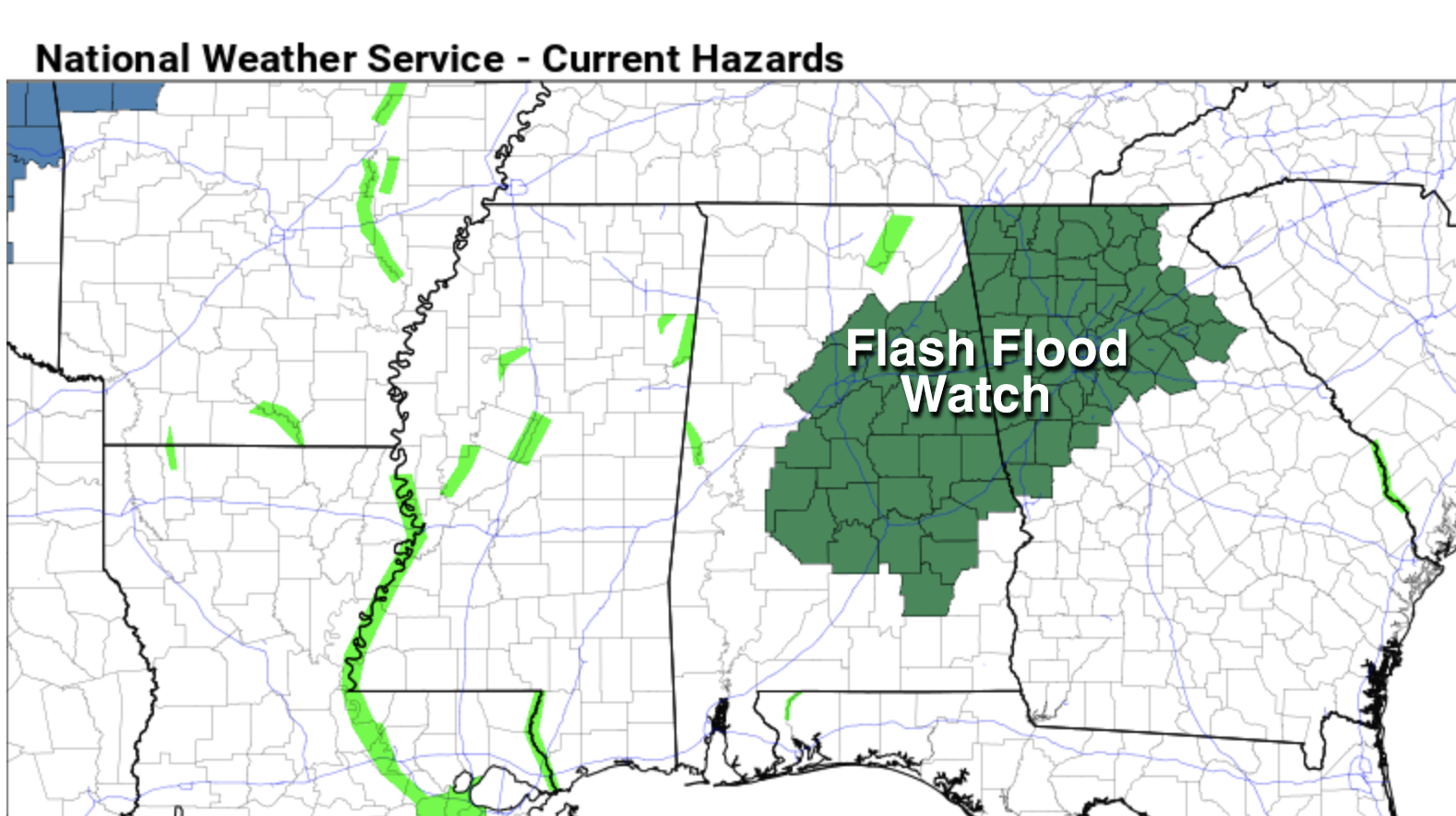
RAIN: A flash flood watch has been issued for parts of Central and East Alabama, including cities like Birmingham, Clanton, Selma, Montgomery, Alexander City, Anniston, and Gadsden. Rain amounts in this part of the state could exceed 3 inches between now and Thursday night. Amounts for the rest of the state will be in the 2-3 inch range.
Be sure you have a good way of hearing severe weather warnings tomorrow night if they are needed. Know your safe place, and have helmets for everyone there. And, if you live in a mobile home, understand you can’t stay there during a tornado warning. Know where you are going, and the quickest way to get there.
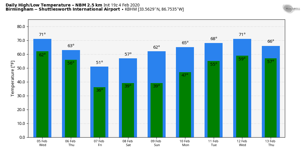
THURSDAY/FRIDAY: Thursday will be wet and sharply colder with falling temperatures. We expect periods of rain Thursday with temperatures falling through the 50s, possible reaching the upper 40s by mid to late afternoon. It will be a very sharp change from the recent warmth. The rain tapers off Thursday night, and thermal values hint there could be a snowflake or two over the northern quarter of the state late Thursday night or during the pre-dawn hours Friday. No impact if that happens. Then, during the day Friday, look for a mix of sun and clouds with a high only in the low 50s.
THE ALABAMA WEEKEND: The next wave will bring a chance of some scattered light rain Saturday and Saturday night; amounts should be under one-tenth of an inch, and we don’t expect any thunder. Otherwise Saturday will be mostly cloudy and cool with a high in the mid to upper 50s. Then, Sunday will be dry and pleasant… the high will be in the 60-65 degree range with a partly sunny sky.
NEXT WEEK: New model data suggests rain could return as early as Monday; much of the week looks mild and unsettled with lots of clouds and occasional showers. Highs will be generally in the 60s. See the Weather Xtreme video for maps, graphics, and more details.
ON THIS DATE IN 1995: A massive nor’easter pounded areas from the southern Mid-Atlantic to northern New England. It would be the only significant storm in the 94-95 winter season. Over 20 inches of snow buried parts of upstate New York. Wind chills dropped as cold as 40 degrees below zero. Behind the storm, arctic air crossing the relatively warm waters of the Great Lakes produced intense lake effect squalls for nearly two weeks from the 4th through the 14th. Snowfall totals for the storm ranged from near two to seven feet. At one point during the storm east of Lake Ontario, snow was falling at the incredible rate of five inches an hour.
STORM SPOTTER TRAINING: Our annual storm spotter training is this Saturday, February 8 at the Hoover Met. It begins at 9:30; and there is no cost. We will offer both the basic and advanced training sessions… we expect to wrap up by 2:30. No need to register; just show up with a curious mind. We need more trained storm spotters! Help us make the warning process better!
BEACH FORECAST: Click here to see the AlabamaWx Beach Forecast Center page.
WEATHER BRAINS: Don’t forget you can listen to our weekly 90 minute show anytime on your favorite podcast app. This is the show all about weather featuring many familiar voices, including our meteorologists here at ABC 33/40.
CONNECT: You can find me on all of the major social networks…
Facebook
Twitter
Instagram
Pinterest
Snapchat: spannwx
I had a great time today visiting with the students at York West End Junior High in Sumter County… be looking for them on the Pepsi KIDCAM today at 5:00 on ABC 33/40 News! The next Weather Xtreme video will be posted here by 7:00 a.m. tomorrow…
Category: Alabama's Weather, ALL POSTS, Weather Xtreme Videos
About the Author (Author Profile)
James Spann is one of the most recognized and trusted television meteorologists in the industry. He holds the AMS CCM designation and television seals from the AMS and NWA. He is a past winner of the Broadcast Meteorologist of the Year from both professional organizations.Subscribe
If you enjoyed this article, subscribe to receive more just like it.


