Wet/Stormy This Morning; Flooding Possible Tomorrow
**No Weather Xtreme video this morning**
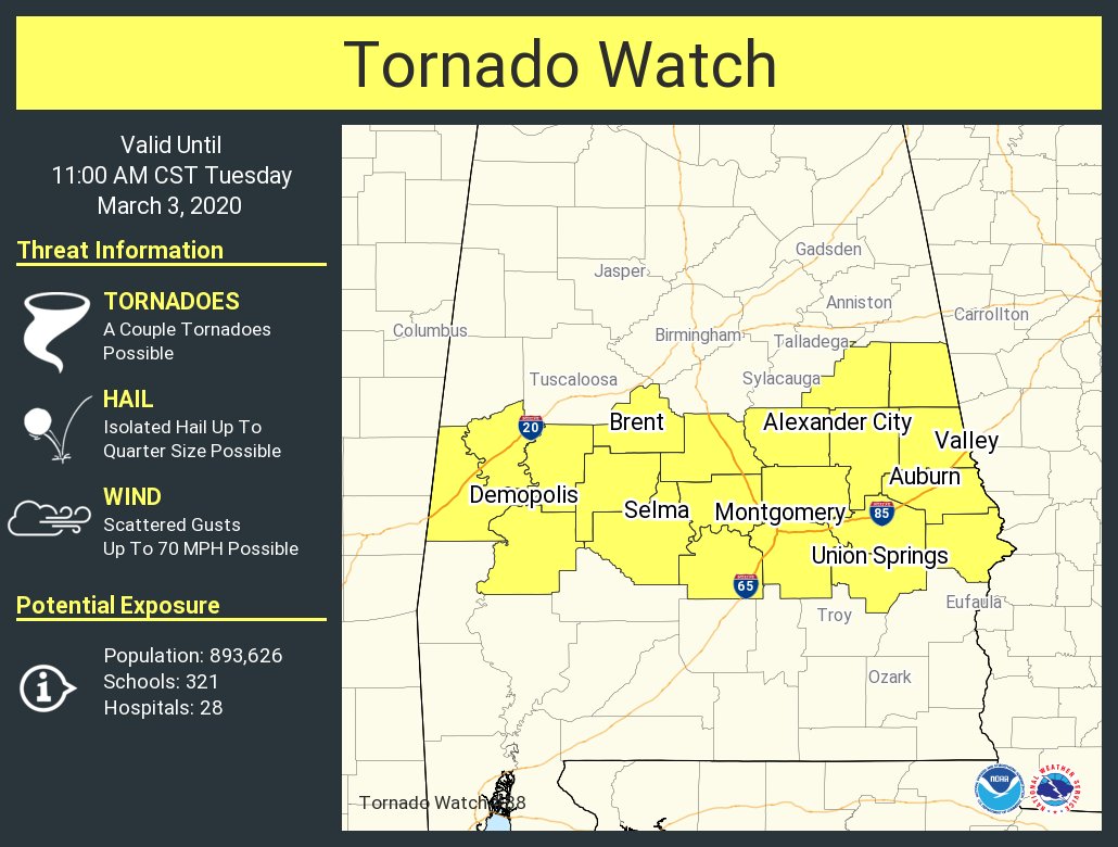
STORMY START: A tornado watch is in effect until 11a CT for parts of Central Alabama… A cluster of storms with embedded supercells and bowing segments will move eastward across central Alabama through the morning. The threat for damaging gusts and a couple of tornadoes will increase some as it warms and moistens at the surface through the morning. The watch runs in a broad zone from Demopolis to Selma to Montgomery to Opelika… it does not include Tuscaloosa, Birmingham, Anniston, or Gadsden…
This is a long a boundary between rain cooled air to the north, and warm, unstable air to the south. Otherwise, rain is likely this morning over much of the state as a surface front approaches. A slot of drier air in the mid levels will work in here by midday, and most of the afternoon will be dry and mild with only isolated showers. Temperatures will reach the low 70s this afternoon.
TOMORROW: The surface front will move down to near the Gulf Coast tonight, and a wave of low pressure forms on the front west of Alabama. This will spread widespread rain into the state, and the rain could be heavy at times. The air will be cool and stable over North/Central Alabama, and the severe weather threat will be limited to the southern quarter of the state, where SPC maintains a “slight risk” (level 2/5) of severe thunderstorms.
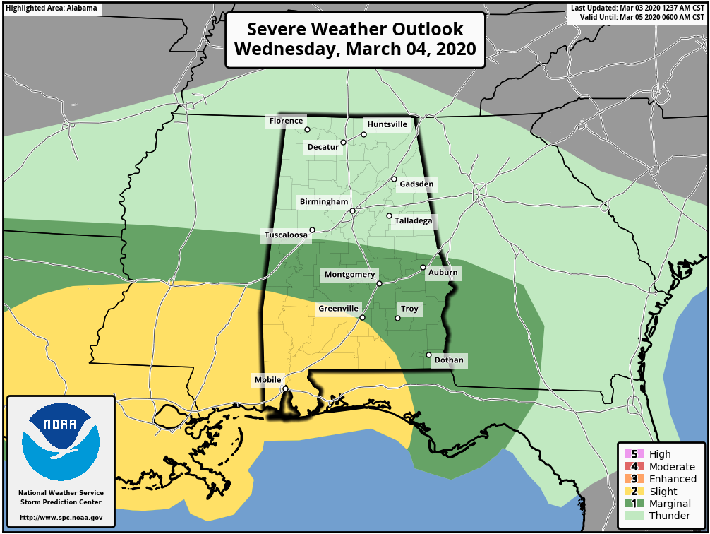
A few storms over South Alabama could produce hail, strong winds, and a tornado or two. For the northern half of the state, flooding is the threat tomorrow with periods of heavy rain.
THURSDAY: Rain continues during the morning, but will end from west to east during the day as drier air works into the state. The high Thursday will be in the upper 50s. We should mention additional rain amounts of 1-3″ are likely between now and Thursday morning, with isolated heavier amounts.
FRIDAY AND THE WEEKEND: The weather will be dry on these three days. Sunny days, clear nights. The high Friday and Saturday will be near 60, and then we rise into the mid to upper 60s Sunday. A very nice weekend.
NEXT WEEK: Rain returns early in the week… most likely Monday night into Tuesday. The latter half of the week for now is looking dry and mild with highs mostly in the 60s.

ON THIS DATE ONE YEAR AGO: A strong late-winter/early-spring storm system moved through the southeastern United States. As the conditions deteriorated, dozens of tornadoes touched down across East Alabama, the panhandle of Florida, and western Georgia causing widespread damage. The deadliest was an EF-4 in Lee County between the towns of Beauregard and Smiths Station, south of Auburn and Opelika. The twister touched down around 2 p.m., and stayed on the ground for 26 miles. It leveled homes and buildings in its path, killing 23 people in the town of Beauregard. It was the deadliest tornado since 2013, and the first EF-4 tornado in the United States in almost two years. Most of those that died were in mobile homes.
BEACH FORECAST: Click here to see the AlabamaWx Beach Forecast Center page.
WEATHER BRAINS: Don’t forget you can listen to our weekly 90 minute show anytime on your favorite podcast app. This is the show all about weather featuring many familiar voices, including our meteorologists here at ABC 33/40.
CONNECT: You can find me on all of the major social networks…
Facebook
Twitter
Instagram
Pinterest
Snapchat: spannwx
Look for the next Weather Xtreme video here by 4:00 this afternoon… enjoy the day!
Category: Alabama's Weather, ALL POSTS, Weather Xtreme Videos
About the Author (Author Profile)
James Spann is one of the most recognized and trusted television meteorologists in the industry. He holds the AMS CCM designation and television seals from the AMS and NWA. He is a past winner of the Broadcast Meteorologist of the Year from both professional organizations.Subscribe
If you enjoyed this article, subscribe to receive more just like it.


