Warm, Mostly Dry Today; Rain Returns Tomorrow Afternoon
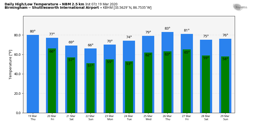
ANOTHER QUIET DAY: Temperatures will rise into the 78-83 degree range across most of Alabama this afternoon with a mix of sun and clouds. We can’t rule out a few showers, but they should be few and far between. The average high for Birmingham on March 19 is 68.
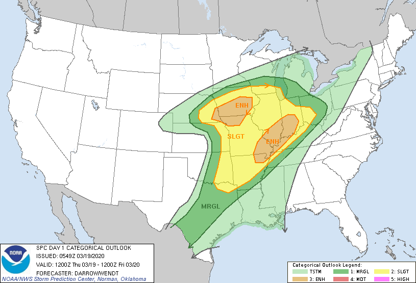
To the west, an upper trough moving of the western U.S. is producing a smorgasbord of weather, including everything from blizzard conditions to strong storms and heavy rain. There is a broad risk of severe thunderstorms from Texas to the Great Lakes, with a couple of “enhanced” risks (level 3/5) included by SPC.
TOMORROW: The main dynamic support will lift north of Alabama, and thankfully we expect no issues with severe storms as the cold front moves into the state. The sky will be cloudy tomorrow, and there will be periods of rain and a few thunderstorms mainly from noon to midnight ahead of the front. Rain amounts will be 1/2 to 1 inch, and the high will be in the 70s.
THE ALABAMA WEEKEND: Cooler, drier air enters North Alabama Saturday; any showers will be confined to the southern quarter of the state. We expect intervals of sun Saturday with a high in the 65-70 degree range. Clouds thicken Saturday night, and periods of rain are likely statewide Sunday as the front lifts northward as a warm front in response to a wave to the west. Sunday’s high will be in the 60s, and rain amounts of around 1/2 inch are likely.
NEXT WEEK: The weather looks pretty quiet through the week with mild/warm afternoons. There could be a day or two with spotty showers, but for now we see no widespread rain. Highs will be mostly in the 70s, but we might see low 80s toward the end of the week. And, still no signs of any severe thunderstorm or flooding issues for Alabama for the next 7-10 days. See the Weather Xtreme video for maps, graphics, and more details.
FIRST DAY OF SPRING: The vernal equinox comes tonight at 10:49p CT; this is the first official day of spring. It is the earliest that the equinox has occurred nationwide in 124 years. We will have approximately 12 hours of daylight and 12 hours of darkness today.
ON THIS DATE IN 2018: An EF-3 tornado tore through Jacksonville, in Calhoun County, heavily damaging the campus of Jacksonville State University. The tornado continued east-southeast and downed many thousands of trees in the Talladega National Forest, areas north of Fruithurst, areas north of Muscadine, and to the Georgia State Line. The tornado damage path to the Georgia State Line was 34.29 miles long. Five other tornadoes touched down across the northern half of Alabama that night, including an EF-2 that moved from near Ashville to Southside.
Large hail produced widespread damage at Cullman; one hailstone there measured 5.38 inches in peak width, weighed 9.8 ounces, and had a circumference of 13.75 inches… now the largest hailstone on record for the state of Alabama.
BEACH FORECAST: Click here to see the AlabamaWx Beach Forecast Center page.
WEATHER BRAINS: Don’t forget you can listen to our weekly 90 minute show anytime on your favorite podcast app. This is the show all about weather featuring many familiar voices, including our meteorologists here at ABC 33/40.
CONNECT: You can find me on all of the major social networks…
Facebook
Twitter
Instagram
Pinterest
Snapchat: spannwx
Look for the next Weather Xtreme video here by 4:00 this afternoon…. enjoy the day!
Category: Alabama's Weather, ALL POSTS, Weather Xtreme Videos
About the Author (Author Profile)
James Spann is one of the most recognized and trusted television meteorologists in the industry. He holds the AMS CCM designation and television seals from the AMS and NWA. He is a past winner of the Broadcast Meteorologist of the Year from both professional organizations.Subscribe
If you enjoyed this article, subscribe to receive more just like it.


