A Few Strong Storms Tomorrow Afternoon; Cooler Weekend Ahead
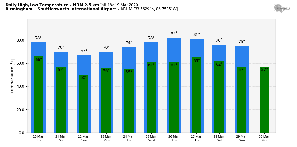
WARM MARCH DAY: Temperatures are mostly in the 78-83 degree range across Alabama this afternoon with a mix of sun and clouds. We note a few spotty showers over the western half of the state, but most communities remain dry.
To the west, a big storm system is bringing everything from blizzard conditions to potential for severe storms and tornadoes, but Alabama’s weather will remain quiet tonight with showers remaining few and far between.
TOMORROW: At midday SPC introduced a low end, “marginal risk” (level 1/5) of severe thunderstorms for a pretty good part of Alabama.
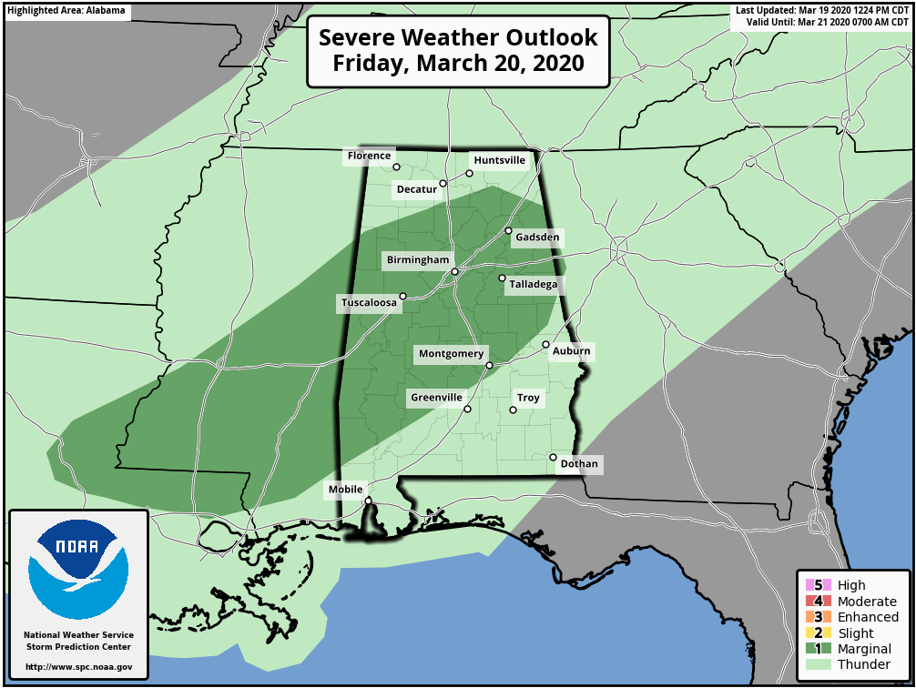
Let me say up front that we do NOT expect any tornadoes in Alabama tomorrow. Wind profiles will be basically unidirectional, and there is no storm relative helicity (veering of the wind with attitude in relation to storm motion). But, a few storms tomorrow afternoon and evening could produce gusty winds and hail. The main window for rain will come from about noon to midnight; rain amounts of 1/2 to 1 inch are likely. The high tomorrow will be in the mid 70s.
THE ALABAMA WEEKEND: Any showers on Saturday should be confined to the far southern part of the state; the sky will feature more clouds than sun over North/Central Alabama with a high between 65 and 70 degrees. Then, on Sunday, the front over South Alabama will lift northward as a warm front, and periods of rain are likely statewide with temperatures generally in the 60s. Rain amounts on Sunday should be close to 1/2 inch.
NEXT WEEK: A few showers are possible Monday and Tuesday, but for now we aren’t expecting anything widespread or heavy. The latter half of the week looks relatively dry with just a small risk of a shower Wednesday through Friday. Temperatures should reach the low 80s Wednesday and Thursday…. See the Weather Xtreme video for maps, graphics, and more details.
FIRST DAY OF SPRING: The vernal equinox comes tonight at 10:49p CT; this is the first official day of spring. It is the earliest that the equinox has occurred nationwide in 124 years. We will have approximately 12 hours of daylight and 12 hours of darkness today.
ON THIS DATE IN 2018: An EF-3 tornado tore through Jacksonville, in Calhoun County, heavily damaging the campus of Jacksonville State University. The tornado continued east-southeast and downed many thousands of trees in the Talladega National Forest, areas north of Fruithurst, areas north of Muscadine, and to the Georgia State Line. The tornado damage path to the Georgia State Line was 34.29 miles long. Five other tornadoes touched down across the northern half of Alabama that night, including an EF-2 that moved from near Ashville to Southside.
Large hail produced widespread damage at Cullman; one hailstone there measured 5.38 inches in peak width, weighed 9.8 ounces, and had a circumference of 13.75 inches… now the largest hailstone on record for the state of Alabama.
BEACH FORECAST: Click here to see the AlabamaWx Beach Forecast Center page.
WEATHER BRAINS: Don’t forget you can listen to our weekly 90 minute show anytime on your favorite podcast app. This is the show all about weather featuring many familiar voices, including our meteorologists here at ABC 33/40.
CONNECT: You can find me on all of the major social networks…
Facebook
Twitter
Instagram
Pinterest
Snapchat: spannwx
Look for the next Weather Xtreme video here by 7:00 a.m. tomorrow…
Category: Alabama's Weather, ALL POSTS, Weather Xtreme Videos
About the Author (Author Profile)
James Spann is one of the most recognized and trusted television meteorologists in the industry. He holds the AMS CCM designation and television seals from the AMS and NWA. He is a past winner of the Broadcast Meteorologist of the Year from both professional organizations.Subscribe
If you enjoyed this article, subscribe to receive more just like it.


