Next Round of Storms Comes On Thursday
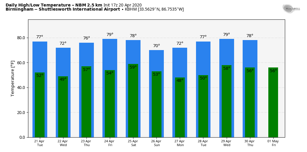
SUNNY AFTERNOON: Nothing but sunshine over the northern half of Alabama this afternoon; temperatures are generally in the 68-73 degree range. Tonight will be clear and cool with a low between 48 and 53 degrees.
Tomorrow will be another sunny day with a high in the mid to upper 70s. Wednesday will be dry, but clouds increase late in the day into Wednesday night as another spring storm system approaches.
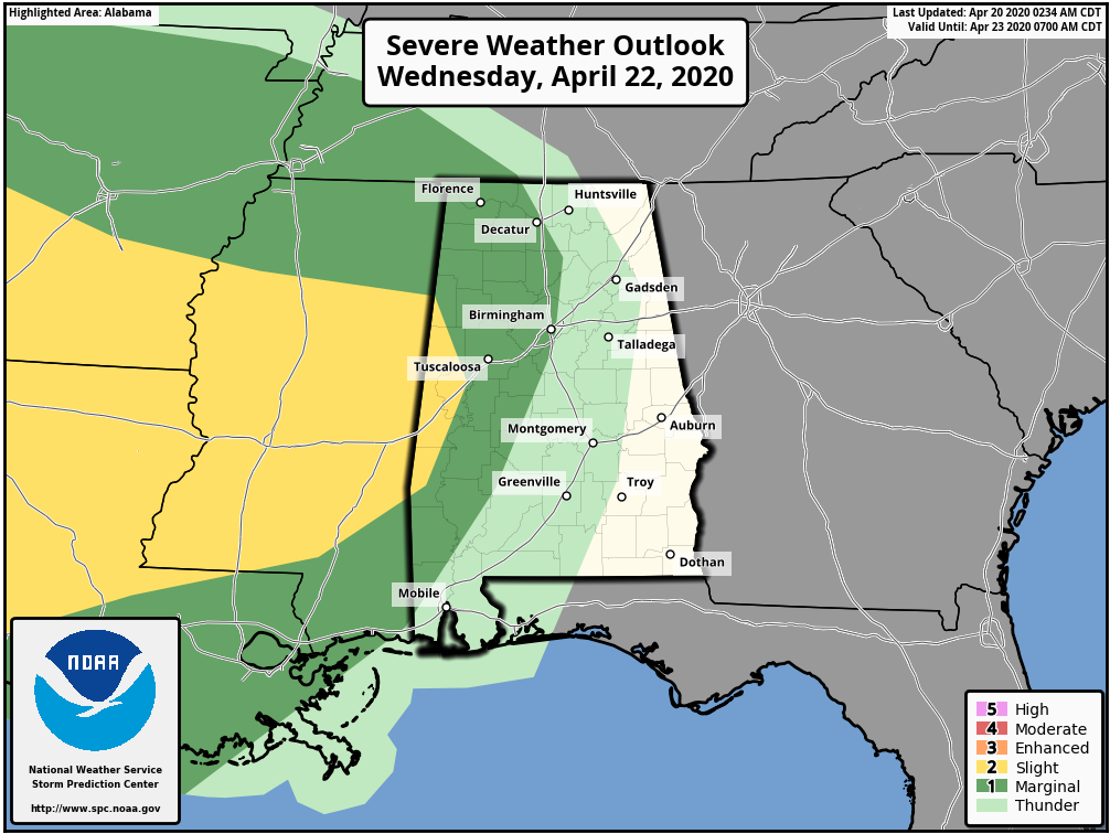
NEXT ROUND OF STORMS: Showers and storms return to Alabama after midnight Wednesday night into the daytime hours Thursday. Models have trended a little slower, suggesting the main window for rain comes from 3:00 a.m. to 3:00 p.m. Thursday. SPC has parts of West Alabama in a “marginal” to “slight” risk of severe storms in their Day 3 outlook, which is valid through 7:00 a.m. Thursday.
If the system is slower, and the thunderstorms come more during the midday and afternoon hours Thursday, there could be sufficient instability for severe thunderstorms statewide. We will have a much better look at the situation tomorrow when we are within range (60 hours) of the high resolution computer models. It looks like rain amounts will be in the 1-2 inch range. The sky will clear by Thursday night.
FRIDAY AND THE WEEKEND: Friday looks dry with a high in the upper 70s, but another fast moving system will bring yet another band of rain and thunderstorms to the state after midnight Friday night into Saturday morning. Too early to know if this one will bring the threat of severe thunderstorms. Then, the sky clears Saturday afternoon, followed by a sunny day Sunday. Highs over the weekend will range from 68 to 72 for most communities across North/Central Alabama.
NEXT WEEK: Monday and Tuesday look dry with seasonal temperatures; next chance of rain and thunderstorms will come in the Wednesday/Thursday time frame. See the Weather Xtreme video for maps, graphics, and more details.
RAIN TOTALS: Updated rain totals across Alabama yesterday…
Jemison 7.87″
Tuscaloosa 6.69″
Auburn 6.56″
Thursday 6.38″
Coker 5.15″
Bibbville 5.04″
Cottondale 4.79″
Grayson Valley 4.01″
Northport 3.81″
Bessemer 3.63″
Mountain Brook 3.39″
Margaret 3.32″
Hueytown 3.25″
Heflin 3.08″
Montgomery 3.02″
Demopolis 2.49″
Jacksonville 2.17″
At least one person was killed in the state due to storms last night; 61-year-old Jerry Oliver Williams of Henry County was killed when a suspected tornado hit a mobile home. Rescuers found the man’s body under the wreckage, but his wife and child weren’t hurt.
ON THIS DATE IN 1920: Tornadoes in Mississippi and Alabama killed 219 persons. Six tornadoes of F4 intensity were reported. Aberdeen, Mississippi was hard hit by an F4 tornado that killed 22 people. This same tornado killed 20 in Marion County, Alabama. Nine people in one family died in Winston County, Alabama.
BEACH FORECAST: Click here to see the AlabamaWx Beach Forecast Center page.
WEATHER BRAINS: Don’t forget you can listen to our weekly 90 minute show anytime on your favorite podcast app. This is the show all about weather featuring many familiar voices, including our meteorologists here at ABC 33/40.
CONNECT: You can find me on all of the major social networks…
Facebook
Twitter
Instagram
Pinterest
Snapchat: spannwx
Look for the next Weather Xtreme video here by 7:00 a.m. tomorrow…
Category: Alabama's Weather, ALL POSTS, Weather Xtreme Videos
About the Author (Author Profile)
James Spann is one of the most recognized and trusted television meteorologists in the industry. He holds the AMS CCM designation and television seals from the AMS and NWA. He is a past winner of the Broadcast Meteorologist of the Year from both professional organizations.Subscribe
If you enjoyed this article, subscribe to receive more just like it.


