Cold Front Moves In Later Today; Much Cooler Tomorrow
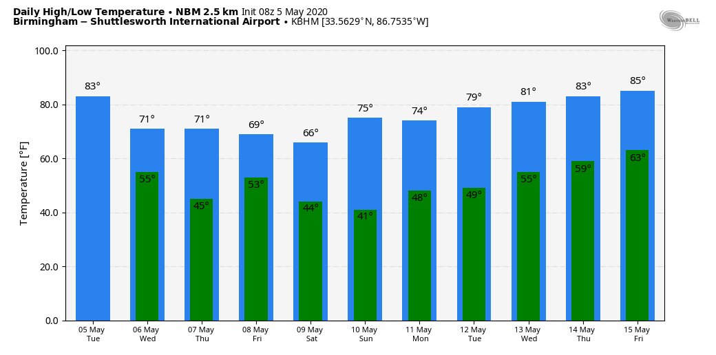
ONE MORE WARM DAY: Yesterday’s official high at Birmingham was 87 degrees, making it the warmest day so far in 2020. We project a high in the low 80s today, but a cold front arriving this afternoon will bring a significant change in the weather. A band of scattered showers and storms will form ahead of the front, and SPC has defined a “marginal risk” (level 1/5) for areas north and east of Birmingham.
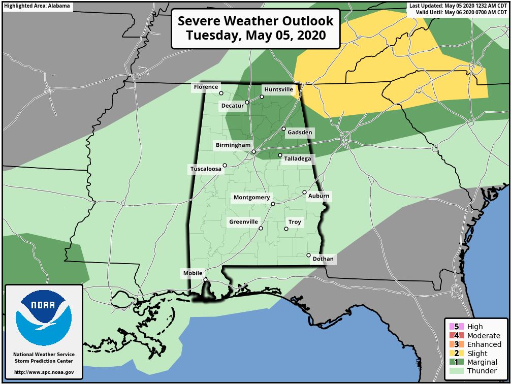
Some of the storms that form this afternoon in the general window from 2 until 8 p.m. could produce small hail and strong gusty winds, but the overall threat is low, and there is no risk of a tornado. Rain amounts will be light and spotty.
COOL CHANGE: Much cooler air rolls into the state tomorrow; the high will be only in the 65-70 degree range over the northern half of the state with a stiff north wind of 15-25 mph. We expect a mix of sun and clouds, although a cloud deck could move into Northeast Alabama during the afternoon with a sprinkle or two. Then, by Thursday morning, temperatures will drop into the 42-46 degree range with a clear sky.
Thursday will be a dry day with sunshine in full supply along with a high around 70 degrees, about ten degrees below average. Clouds will increase Thursday night.
FRIDAY AND THE WEEKEND: Another cold front will bring a chance of showers, and possibly a thunderstorms Friday. Rain amounts should be 1/2 inch or less, and no severe storms are expected. Then, yet another surge of cooler air blows into the Deep South Friday night. Saturday will be a sunny but cool day; the high will be in the mid 60s, about 15 degrees below average for mid-May. By early Sunday morning we project a low in the low 40s for most communities, but some of the colder valleys across North Alabama will dip into the 30s with potential for a touch of light frost.
Birmingham’s record low for May 10 is 38, set in 1966, and we will be very close to that level. Then, during the day Sunday the sky will be sunny with a high in the mid 70s.
NEXT WEEK: The week looks quiet for now with highs rising back into the 80s by Thursday and Friday (May 14-15)… there could be a few showers Wednesday, but no sign of any major rain or storm event at this point. See the Weather Xtreme video for maps, graphics, and more details.
ON THIS DATE IN 1933: Two devastating tornadoes were responsible for 25 deaths and 227 injuries in Central Alabama in the predawn hours of May 5, 1933. The first was an F3 tornado which touched down at 12:20 a.m. and moved through Choctaw, Sumter, and Marengo counties, killing four and injuring 27 people along its 35 mile long path. Three of the fatalities occurred at Demopolis in Marengo County where 50 homes were destroyed.
The second tornado touched down around 2:30 a.m. and moved through Bibb and Shelby counties along a 35 mile long path. This tornado had damage consistent with an F4 rating and was responsible for 21 deaths and 200 injuries. Hardest hit was the Shelby County town of Helena. A total of 14 were killed and 150 were injured. Five were killed in Brent in Bibb County and one was killed in the Colemont community.
BEACH FORECAST: Click here to see the AlabamaWx Beach Forecast Center page.
WEATHER BRAINS: Don’t forget you can listen to our weekly 90 minute show anytime on your favorite podcast app. This is the show all about weather featuring many familiar voices, including our meteorologists here at ABC 33/40.
CONNECT: You can find me on all of the major social networks…
Facebook
Twitter
Instagram
Pinterest
Snapchat: spannwx
Look for the next Weather Xtreme video here by 4:00 this afternoon… enjoy the day!
Category: Alabama's Weather, ALL POSTS, Weather Xtreme Videos
About the Author (Author Profile)
James Spann is one of the most recognized and trusted television meteorologists in the industry. He holds the AMS CCM designation and television seals from the AMS and NWA. He is a past winner of the Broadcast Meteorologist of the Year from both professional organizations.Subscribe
If you enjoyed this article, subscribe to receive more just like it.


