Showers/Storms This Evening; Much Cooler Tomorrow
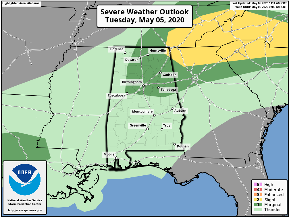
RADAR CHECK: Showers and thunderstorms continue to increase across North Alabama this afternoon ahead of a cold front. These will drop southward in coming hours, and will be capable of producing small hail and strong gusty winds. SPC maintains a low end, “marginal risk” (level 1/5) of severe thunderstorms for roughly the northern third of the state through the evening hours.
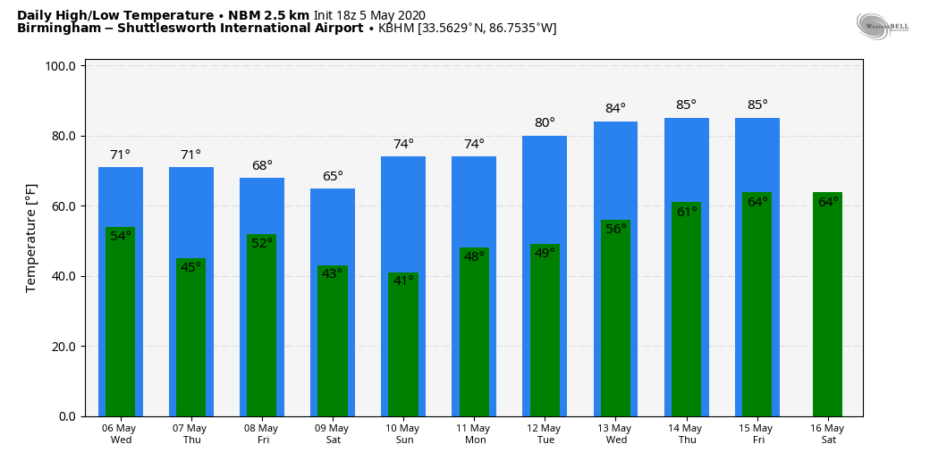
COOLER AIR ROLLS IN: Tomorrow will be a windy and much cooler day with a high between 65 and 70 degrees. We expect a mix of sun and clouds, although clouds could hover Northeast Alabama much of the day. The average high for tomorrow (May 6) at Birmingham is 80. We drop into the 40s early Thursday morning with a clear sky and diminishing wind. Then, during the day Thursday, the sky will be sunny with a high around 70 degrees. Clouds increase Thursday night.
Another cold front blows into the state Friday with showers, and possibly a thunderstorm. No risk of severe storms, and rain should be light, mostly under 1/2 inch.
THE ALABAMA WEEKEND: Even cooler air arrives. Saturday will be sunny with a high in the mid 60s, and by early Sunday we drop into the 37-42 degree range. A very real chance of frost for colder valleys and protected areas across North/Central Alabama. Birmingham’s record low for May 10 is 38, set in 1966, and we will be very close to that level. Then, during the day Sunday the sky will be sunny with a high in the mid 70s.
NEXT WEEK: The weather will be dry Monday and Tuesday with highs in the 70s. A few showers are possible at mid-week Wednesday, followed by dry and warmer weather Thursday and Friday when highs return to the 80s. See the Weather Xtreme video for maps, graphics, and more details.
ON THIS DATE IN 1933: Two devastating tornadoes were responsible for 25 deaths and 227 injuries in Central Alabama in the predawn hours of May 5, 1933. The first was an F3 tornado which touched down at 12:20 a.m. and moved through Choctaw, Sumter, and Marengo counties, killing four and injuring 27 people along its 35 mile long path. Three of the fatalities occurred at Demopolis in Marengo County where 50 homes were destroyed.
The second tornado touched down around 2:30 a.m. and moved through Bibb and Shelby counties along a 35 mile long path. This tornado had damage consistent with an F4 rating and was responsible for 21 deaths and 200 injuries. Hardest hit was the Shelby County town of Helena. A total of 14 were killed and 150 were injured. Five were killed in Brent in Bibb County and one was killed in the Colemont community.
BEACH FORECAST: Click here to see the AlabamaWx Beach Forecast Center page.
WEATHER BRAINS: Don’t forget you can listen to our weekly 90 minute show anytime on your favorite podcast app. This is the show all about weather featuring many familiar voices, including our meteorologists here at ABC 33/40.
CONNECT: You can find me on all of the major social networks…
Facebook
Twitter
Instagram
Pinterest
Snapchat: spannwx
Look for the next Weather Xtreme video here by 7:00 a.m. tomorrow…
Category: Alabama's Weather, ALL POSTS, Weather Xtreme Videos
About the Author (Author Profile)
James Spann is one of the most recognized and trusted television meteorologists in the industry. He holds the AMS CCM designation and television seals from the AMS and NWA. He is a past winner of the Broadcast Meteorologist of the Year from both professional organizations.Subscribe
If you enjoyed this article, subscribe to receive more just like it.


