Cool Afternoon For Mid May
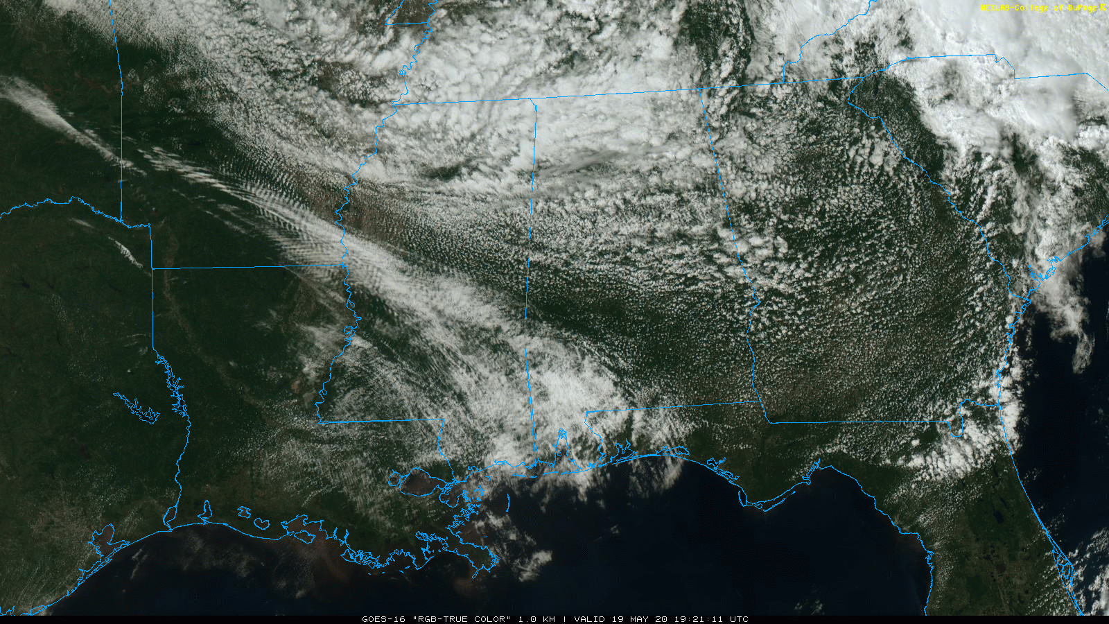
COOL MAY DAY: Temperatures are only in the mid-60s across parts of North Alabama this afternoon, almost 20 degrees below average for the middle of May. An upper low over Tennessee has pushed clouds into the northern half of the state keeping temperatures down. But, to the south, there is a decent amount of sunshine over the southern half of the state, where mid-80s are being reported. The radar is very quiet, showing basically nothing over all of Alabama at mid-afternoon. We will keep the chance of scattered showers in the forecast for North Alabama this evening, but most places will be dry.
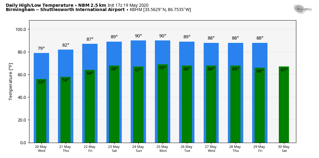
REST OF THE WEEK: Not much change tomorrow; for most places the high will be in the mid to upper 70s with a partly sunny sky and some risk of widely scattered afternoon showers. Then, we warm into the low-80s Thursday and mid-80s Friday as the upper low weakens and lifts out. The air becomes a little more unstable with the warmer days, and we will have the chance of random, scattered, mostly afternoon and evening showers and thunderstorms on these two days. Odds of any one spot getting wet will be in the 20/30 percent range.
THE ALABAMA WEEKEND: No real change. Partly sunny, warm days and mostly fair nights Saturday and Sunday with scattered showers and thunderstorms possible, mostly between 1:00 and 9:00 p.m. Chance of any one spot getting wet both days will be around 30/40 percent. Very typical for late May in Alabama, and you will hear this forecast pretty much on a daily basis during the summer months. The rain won’t be widespread, but some could see a heavy downpour. No way of knowing in advance exactly when and where the showers will form; you just have to watch radar trends.
NEXT WEEK: Looks like a warm week with highs between 87 and 90 degrees on most afternoons. Partly sunny days, and again the risk of scattered, mostly afternoon and evening showers and thunderstorms. See the Weather Xtreme video for maps, graphics, and more details.
ARTHUR: Arthur is now a post-tropical system in the Atlantic, well east of the North Carolina coast. The remnant circulation will loop harmlessly in the Atlantic in the coming days as it dissipates. NHC has issued the last advisory on the system.
The “official” start of the hurricane season is June 1. After Arthur, the names will be Bertha, Cristobal, Dolly, Edouard, Fay, Gonzalo, Hanna, Isaias, Josephine, Kyle, Laura, Marco, Nana, Omar, Paulette, Rene, Sally, Teddy, Vicky, and Wilfred.
ON THIS DATE IN 1780: The infamous “dark day” in New England tradition. At noon, it was nearly as dark as night. Chickens went to roost, and many persons were fearful of divine wrath. The “dark day” was caused by forest fires to the west of New England.
BEACH FORECAST: Click here to see the AlabamaWx Beach Forecast Center page.
WEATHER BRAINS: Don’t forget you can listen to our weekly 90 minute show anytime on your favorite podcast app. This is the show all about weather featuring many familiar voices, including our meteorologists here at ABC 33/40.
CONNECT: You can find me on all of the major social networks…
Facebook
Twitter
Instagram
Pinterest
Snapchat: spannwx
Look for the next Weather Xtreme video here by 7:00 a.m. tomorrow…
Category: Alabama's Weather, ALL POSTS, Weather Xtreme Videos
About the Author (Author Profile)
James Spann is one of the most recognized and trusted television meteorologists in the industry. He holds the AMS CCM designation and television seals from the AMS and NWA. He is a past winner of the Broadcast Meteorologist of the Year from both professional organizations.Subscribe
If you enjoyed this article, subscribe to receive more just like it.


