Moisture Levels Rise; Scattered Showers/Storms Return Later Today
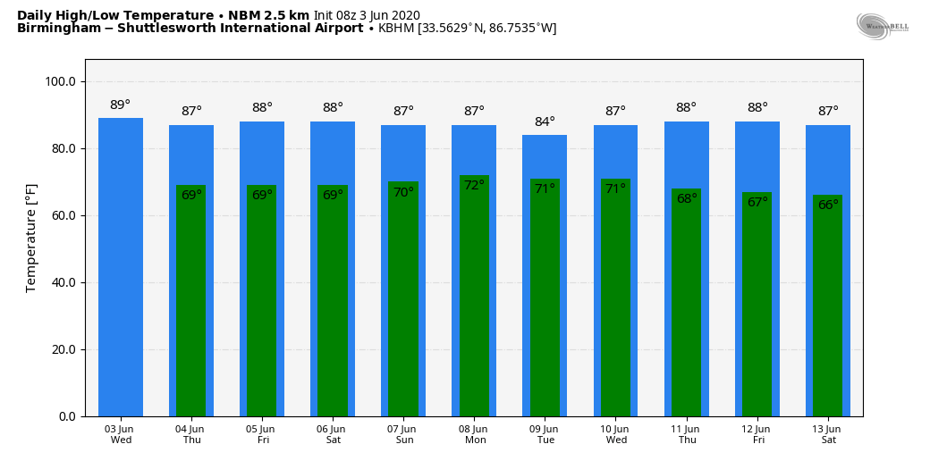
WARM, HUMID DAYS: The radar is quiet across Alabama this morning, but we expect the return of scattered showers and thunderstorms this afternoon in response to rising moisture levels. Most of the showers will come from about 1:00 until 9:00 p.m., and the chance of any one spot getting wet is 40 percent. The high will be in the mid to upper 80s.
There won’t be much change tomorrow and Friday. Warm, humid days with “scattered, mostly afternoon and evening showers and thunderstorms”. No way of knowing in advance exactly when and where the thunderstorms pop up; you just have to keep a close eye on radar trends if you have something planned outdoors. Highs will remain in the 85-90 degree range.
THE ALABAMA WEEKEND: The weather remains the same Saturday, but we expect an increase in the number of showers and storms Sunday in response to tropical moisture being pulled northward due to the system in the Gulf of Mexico. The sun will be out at times both days, and highs will be in the 80s.
NEXT WEEK: High precipitable water values will stick around much of the week, and each day will feature a mix of sun and clouds with scattered showers and thunderstorms; the highest coverage most likely will come on Monday as Cristobal passes west of the state on the journey northward. Highs will be in the 80s, lows around 70. See the Weather Xtreme video for maps, graphics, and more details.
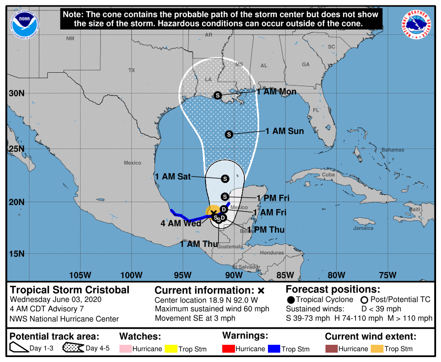
TROPICAL STORM CRISTOBAL: The system in the far Southwest Gulf of Mexico is packing sustained winds of 60 mph this morning. On the forecast track, the center will cross the southern Bay of Campeche coast later today and move inland over eastern Mexico tonight and tomorrow. The center is forecast to move back over the Bay of Campeche tomorrow night and Friday.
Some slight increase in strength is possible until the center crosses the coast. Gradual weakening is forecast while the center remains inland, but restrengthening is expected after Cristobal moves back over water tomorrow night and Friday.
The latest NHC track places Cristobal on the Louisiana coast Sunday night as an upper-end tropical storm. The main impact will come from heavy rain and potential flooding.
ALABAMA/NORTHWEST FLORIDA GULF COAST: If you have a beach trip planned, or live along the Central Gulf Coast, expect a mix of sun and clouds today through Friday with the usual risk of a passing shower or storm from time to time. As Cristobal approaches, rain coverage will increase over the weekend. This is the expected impact in the zone from Dauphin Island east to Panama City Beach Sunday and Monday:
*Occasional rain and a few thunderstorms. Rain could be heavy at times, and some flooding issues are possible. Rain amounts of 4-6 inches are possible Saturday through Monday.
*Winds Sunday night on the Alabama Gulf Coast will be in the 20-30 mph range, with gusts to 40 mph possible. Velocities will be lower as you go farther east down the Northwest Florida coast. The wind field will be much calmer Monday as Cristobal moves into western Louisiana and weakens.
*A few isolated waterspouts or tornadoes will be possible Sunday afternoon through Monday morning.
*Dangerous rip currents are likely over the weekend, and through at least Monday.
*Showers and storms will thin out Tuesday and through the rest of the week, with increasing potential for sun.
This impact forecast is based on the current forecast track and intensity. Understand this can change; always work with the latest forecast information when making decisions.
ON THIS DATE IN 1993: Early morning severe thunderstorms dumped huge hailstones across northern Oklahoma. Hail, up to 6 inches in diameter in Enid, went through roofs of homes, damaged three jets at Vance Air Force Base, and did $500,000 in damage at a car dealership. Winds gusts reached 70 mph at Vance Air Force Base as well. Hail damage to the wheat crop was estimated at 70 million dollars.
BEACH FORECAST: Click here to see the AlabamaWx Beach Forecast Center page.
WEATHER BRAINS: Don’t forget you can listen to our weekly 90 minute show anytime on your favorite podcast app. This is the show all about weather featuring many familiar voices, including our meteorologists here at ABC 33/40.
CONNECT: You can find me on all of the major social networks…
Facebook
Twitter
Instagram
Pinterest
Snapchat: spannwx
Look for the next Weather Xtreme video here by 4:00 this afternoon… enjoy the day!
Category: Alabama's Weather, ALL POSTS, Weather Xtreme Videos
About the Author (Author Profile)
James Spann is one of the most recognized and trusted television meteorologists in the industry. He holds the AMS CCM designation and television seals from the AMS and NWA. He is a past winner of the Broadcast Meteorologist of the Year from both professional organizations.Subscribe
If you enjoyed this article, subscribe to receive more just like it.


