Humid Air/Scattered Showers And Storms Develop Later Today
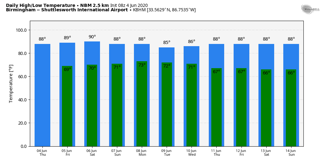
OCEAN OF HUMIDITY: A muggy airmass will hang over Alabama for at least the next five to seven days, meaning each day we will deal with random, scattered showers and thunderstorms. In this pattern, there isn’t any real way of knowing exactly when and where the storms form; if you have something planned outdoors just keep a close eye on radar, and get inside when you hear thunder. The radar is very quiet early this morning, but by midday showers will begin to develop as the air heats up and becomes unstable. Chance of any one spot getting wet today and tomorrow will is about one in two. Highs will be in the mid to upper 80s… about what you expect around here in June.
THE ALABAMA WEEKEND: No real change; scattered showers and storms remain possible Saturday and Sunday, but it won’t rain everywhere. Look for a mix of sun and clouds both days with highs in the 80s. Model data actually suggests there could be a decrease in the number of showers Sunday as we could be in the subsidence ring (sinking air) on the periphery of Tropical Storm Cristobal.
NEXT WEEK: The coverage of scattered showers and storms will likely be a bit higher on Monday as Cristopal moves northward through Louisiana and Arkansas, but the general pattern just won’t change much. Partly sunny, warm, humid days with a few passing showers or storms from time to time. Highs will remain mostly in the mid to upper 80s through the week. There is some hint we could see drier air toward the end of the week, but we will believe it when we see it. See the Weather Xtreme video for maps, graphics, and more details.
TROPICAL STORM CRISTOBAL: This morning the system continues to weaken; winds are down to 40 mph. The center of Tropical Storm Cristobal was located over southern Mexico, and is basically stationary. A movement toward the east and northeast is expected later today, and a subsequent northward motion should occur through Saturday. On the forecast track, the center will move over the landmass of eastern Mexico today and tonight. The center is forecast to move back over the southern Gulf of Mexico tomorrow or tomorrow night, and over the Central Gulf of Mexico on Saturday.
No change in the NHC forecast track; the tropical storm is expected to move into the Louisiana coast Sunday night with winds of 60-65 mph.
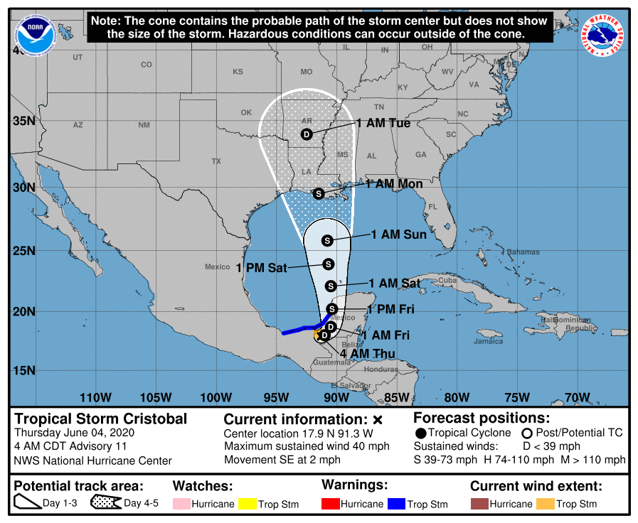
The circulation center will move through Louisiana and Arkansas Monday and Monday night while weakening.
IMPACT FOR THE ALABAMA/NORTHWEST FLORIDA COAST: This discussion is for the area from Dauphin Island, eastward through Gulf Shores, Destin, and Panama City Beach. This part of the coast will be on the wet, east side of the system.
*The sky will be partly sunny along the Central Gulf Coast today and tomorrow with the usual risk of scattered showers and thunderstorms. Expect about 5 to 7 hours of sunshine both days.
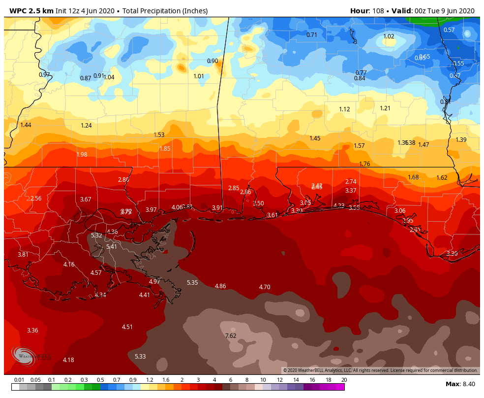
*Coverage of showers and thunderstorms will increase over the weekend, but the rain won’t be continuous, and you should see a few intervals of sunshine both days. Rain could be occasionally heavy, and we expect rain totals in the 2-4 inch range Saturday through Monday. Some flooding is possible in isolated areas, but the higher flood risk is to the west, along the Mississippi coast and Southeast Louisiana.
*Showers will thin out Monday, and the weather looks pretty routine for much of next week with partly sunny days and the usual risk of a passing shower or storm from time to time.
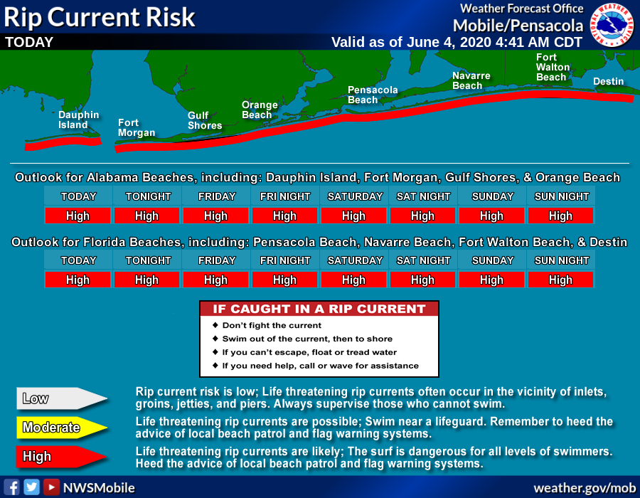
*Dangerous rip currents are likely along the coast today through Sunday.
*A few isolated waterspouts or brief tornadoes are possible Sunday and Sunday night.
*Winds of 15-25 mph are likely Sunday and Sunday night with gusts to 30 mph. Higher wind velocities will remain to the west of the Alabama coast.
If it was me, I would not hesitate to go to the Gulf Shores, Destin, or Panama City Beach this weekend. But, of course, different people go to the beach for different reasons.
ON THIS DATE IN 1877: A tornado of estimated F4 intensity touched down just west of Mt. Carmel, Illinois and moved east-northeast, devastating the town. 20 businesses and 100 homes were damaged or destroyed. At least 16 people and as many as 30 were killed, with 100 others injured.
BEACH FORECAST: Click here to see the AlabamaWx Beach Forecast Center page.
WEATHER BRAINS: Don’t forget you can listen to our weekly 90 minute show anytime on your favorite podcast app. This is the show all about weather featuring many familiar voices, including our meteorologists here at ABC 33/40.
CONNECT: You can find me on all of the major social networks…
Facebook
Twitter
Instagram
Pinterest
Snapchat: spannwx
Look for the next Weather Xtreme video here by 4:00 this afternoon… enjoy the day!
Category: Alabama's Weather, ALL POSTS, Weather Xtreme Videos
About the Author (Author Profile)
James Spann is one of the most recognized and trusted television meteorologists in the industry. He holds the AMS CCM designation and television seals from the AMS and NWA. He is a past winner of the Broadcast Meteorologist of the Year from both professional organizations.Subscribe
If you enjoyed this article, subscribe to receive more just like it.


