Warm And Humid With Hit and Miss Showers/Storms
RADAR CHECK: We have you classic summer pattern of random, scattered showers and thunderstorms across Alabama this afternoon. Away from the showers, we have a mix of sun and clouds with temperatures mostly in the upper 80s. Showers will fade away late tonight as the air cools and becomes more stable.
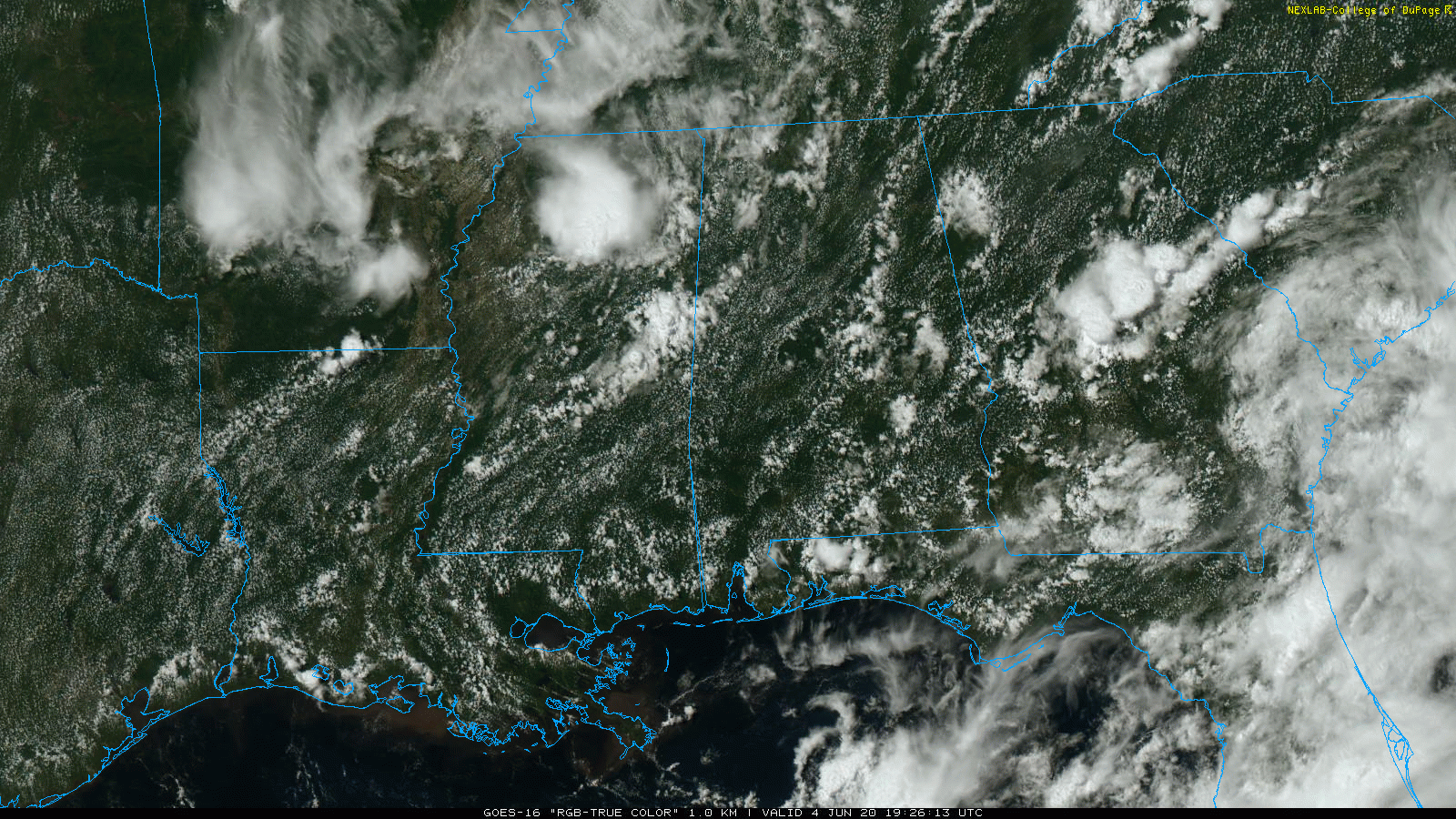
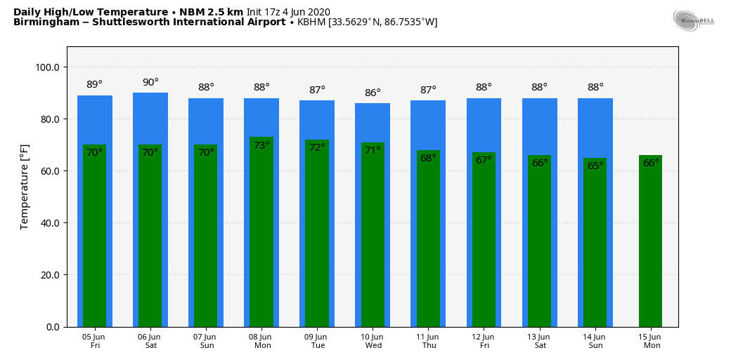
The weather won’t change much tomorrow; partly sunny with scattered showers and storms forming again by afternoon. The chance of any one spot getting wet is 40-50 percent, and the high will be in the upper 80s for most communities.
THE ALABAMA WEEKEND: The weather stays the same Saturday… partly sunny with scattered showers and storms, mostly during the afternoon and evening hours. Model guidance continues to suggest that Sunday will be relatively dry with only isolated showers as we will be in a subsidence area (sinking air motion) on the northern periphery of Tropical Storm Cristobal. Highs over the weekend will remain in the mid to upper 80s.
NEXT WEEK: The classic summer pattern continues for the first half of the week with warm, humid days with the risk of “pop-up”, “splash and dash” showers and storms, mostly during the afternoon and evening hours. Global models continue the trend of moving drier air into the region by Thursday and Friday, and it looks like those days could be generally dry with slightly lower humidity levels. See the Weather Xtreme video for maps, graphics, and more details.
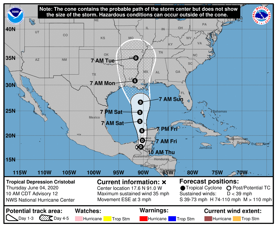
TROPICAL STORM CRISTOBAL: Cristobal is now a tropical depression, inland over Mexico with winds of 35 mph. The depression is moving toward the east-southeast near 3 mph; a turn toward the east and northeast is expected this evening, and a subsequent northward motion should occur through Sunday. On the forecast track, the center will move over the landmass of extreme northwestern Guatemala and eastern Mexico through tonight. The center is forecast to move back over the southern Gulf of Mexico late tomorrow or tomorrow night, over the central Gulf of Mexico on Saturday, and approach the Louisiana coast late in the day Sunday. NHC expects the system to remain below hurricane strength.
ALABAMA/NORTHWEST FLORIDA COASTS: The weather on the Gulf Coast from Dauphin Island and Gulf Shores east to Panama City Beach won’t change much tomorrow; partly sunny with just a few scattered showers or storms around.
*The number of showers and storms will increase over the Gulf Coast over the weekend, and some heavy rain is possible in spots. But, the rain won’t be continuous, and the sun will be out at times.
*Rain amounts on the Alabama and Northwest Florida coasts over the next 5 days will be in the 1 to 3 inch range, with potential for heavier amounts in a few spots.
*Winds Sunday and Sunday night will be in the 15-25 mph range, with possible gusts to 30 mph, but the higher wind velocities associated with the tropical storm will be to the west, across Southeast Louisiana and the Mississippi coast.
*Dangerous rip currents are likely along the coast through Sunday. Expect to see red flags.
*A few isolated waterspouts or brief tornadoes are possible Sunday and Sunday night.
*The weather next week on the Central Gulf Coast looks very routine, with about 7-9 hour of sunshine daily with the usual risk of a passing shower or storm from time to time.
ON THIS DATE IN 1877: A tornado of estimated F4 intensity touched down just west of Mt. Carmel, Illinois and moved east-northeast, devastating the town. 20 businesses and 100 homes were damaged or destroyed. At least 16 people and as many as 30 were killed, with 100 others injured.
BEACH FORECAST: Click here to see the AlabamaWx Beach Forecast Center page.
WEATHER BRAINS: Don’t forget you can listen to our weekly 90 minute show anytime on your favorite podcast app. This is the show all about weather featuring many familiar voices, including our meteorologists here at ABC 33/40.
CONNECT: You can find me on all of the major social networks…
Facebook
Twitter
Instagram
Pinterest
Snapchat: spannwx
Look for the next Weather Xtreme video here by 7:00 a.m. tomorrow…
Category: Alabama's Weather, ALL POSTS, Weather Xtreme Videos
About the Author (Author Profile)
James Spann is one of the most recognized and trusted television meteorologists in the industry. He holds the AMS CCM designation and television seals from the AMS and NWA. He is a past winner of the Broadcast Meteorologist of the Year from both professional organizations.Subscribe
If you enjoyed this article, subscribe to receive more just like it.


