Hot, Humid, A Few Showers; Eyes On Cristobal
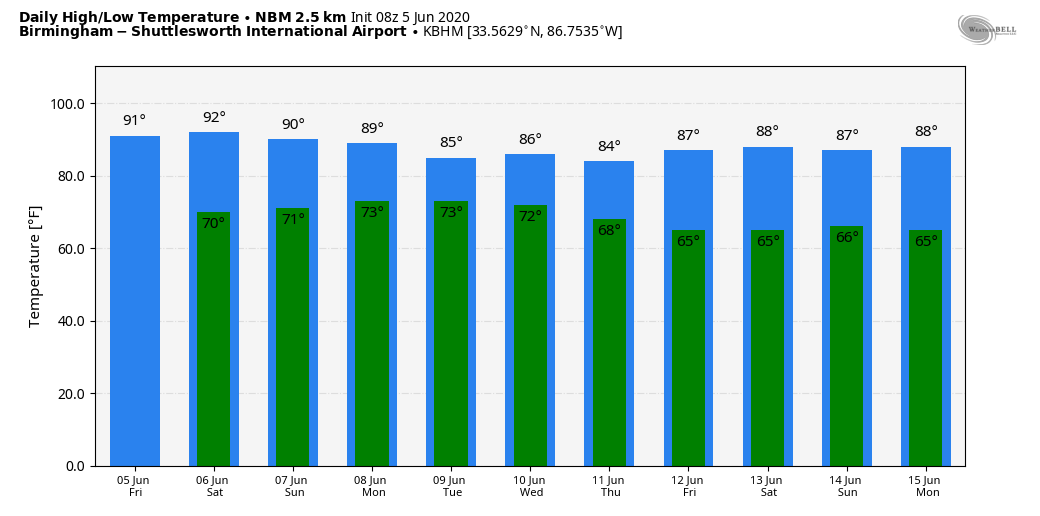
RADAR CHECK: A disturbance in the upper atmosphere is producing an area of showers over the northern quarter of Alabama early this morning; those showers end a little later in the day. Then, during the heat of the afternoon, we expect more random, scattered showers and storms to form across the state. These should be pretty widely spaced today… otherwise, the sky will be partly sunny with a high in the 88-91 degree range.
THE ALABAMA WEEKEND: The northern half of the state should be relatively dry tomorrow and Sunday with a good supply of sunshine and afternoon highs around 90 degrees. Showers are possible, but they should be pretty isolated. Showers will be more numerous over South Alabama, especially Sunday, as Tropical Storm Cristobal approaches the Louisiana coast.
NEXT WEEK: Very humid air will cover the state for the first half of the week, and we will experience scattered showers and thunderstorms Monday through Wednesday with a mix of sun and clouds each day. Showers will thin out later in the week as dry air moves in… See the Weather Xtreme video for maps, graphics, and more details.
CRISTOBAL: The system is still inland this morning over the Yucatan of Mexico; it is a tropical depression with winds of 35 mph. It will move northward into the Gulf of Mexico tonight and should regain tropical storm strength. No real change in the forecast track from NHC; landfall will be Sunday night along the Louisiana coast as a tropical storm.
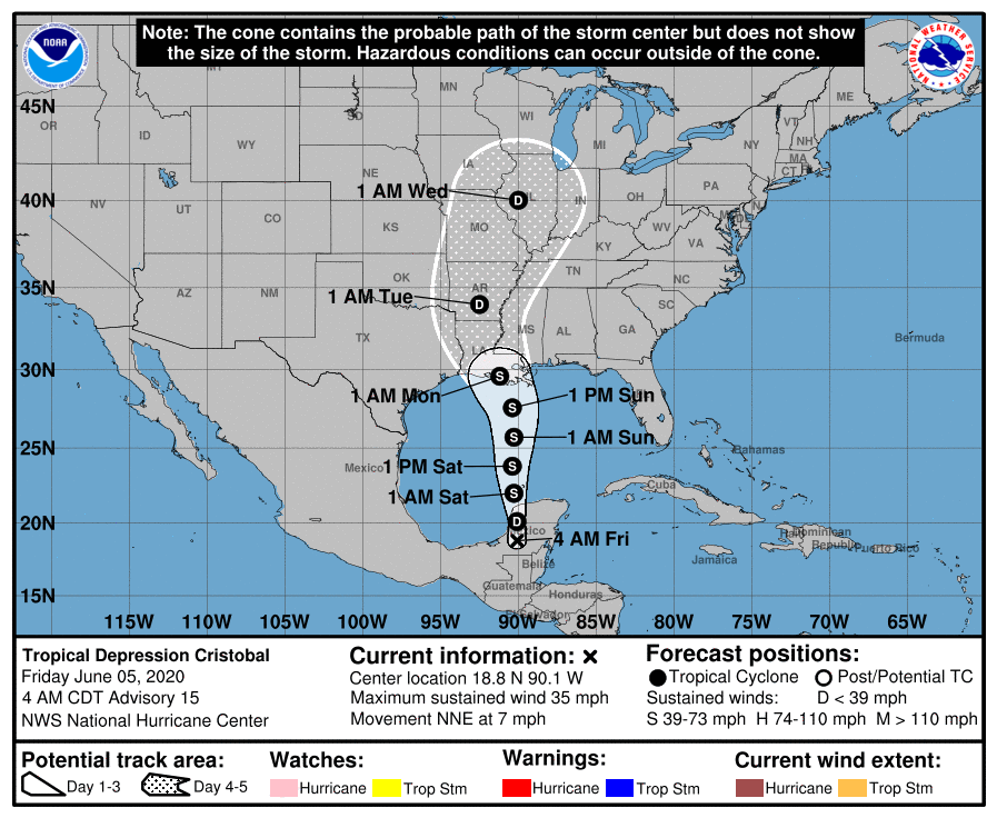
Hurricane strength is unlikely as the system will encounter dry air and moderate shear. Tropical storm watches will be required for parts of the Gulf Coast later today.
IMPACT ON THE ALABAMA/NORTHWEST FLORIDA GULF COAST: This is what to expect for those on the coast from Dauphin Island and Gulf Shores eastward to Panama City Beach…
*The weather today will be nice; about 7 to 9 hours of sunshine with just a few scattered showers. Clouds increase tomorrow, but a decent part of the day will be dry. Periods of rain are likely tomorrow night and Sunday, but the rain won’t be continuous, and you will probably see some sun at times Sunday.
*A few periods of heavier rain are likely, but the highest flooding risk will be to the west across Southeast Louisiana and the Gulf Coast of Mississippi, where flash flood watches have been issued.
*A few isolated waterspouts or brief tornadoes are possible tomorrow night and Sunday.
*Winds of 15-30 mph are likely tomorrow night and Sunday with gusts to 40 mph. Higher wind velocities will be to the west over Louisiana and Mississippi.
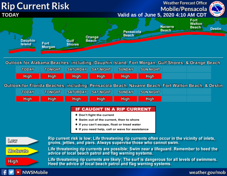
*Dangerous rip currents are likely each day through Sunday. Expect to see red flags on the beaches.
*The weather next week looks routine with 7 to 9 hours of sunshine daily and the usual risk of a passing shower or storm from time to time.
As always, keep an eye on the latest forecast updates.
ON THIS DATE IN 1976: When water began leaking from Idaho’s new Teton Dam, there seemed to be no cause for alarm. On this date, however, warnings were frantic that the dam was about to break. As workers tried to shore up the crumbling dam, it failed shortly after 11 AM, sending 180 billion gallons of water pouring through Teton Canyon. 11 people lost their lives, but the toll would have been much higher if the dam had failed at night and residents had been asleep.
BEACH FORECAST: Click here to see the AlabamaWx Beach Forecast Center page.
WEATHER BRAINS: Don’t forget you can listen to our weekly 90 minute show anytime on your favorite podcast app. This is the show all about weather featuring many familiar voices, including our meteorologists here at ABC 33/40.
CONNECT: You can find me on all of the major social networks…
Facebook
Twitter
Instagram
Pinterest
Snapchat: spannwx
Look for the next Weather Xtreme video here by 4:00 this afternoon… enjoy the day!
Category: Alabama's Weather, ALL POSTS, Weather Xtreme Videos
About the Author (Author Profile)
James Spann is one of the most recognized and trusted television meteorologists in the industry. He holds the AMS CCM designation and television seals from the AMS and NWA. He is a past winner of the Broadcast Meteorologist of the Year from both professional organizations.Subscribe
If you enjoyed this article, subscribe to receive more just like it.


