

Occasional Showers/Storms Continue Across Alabama
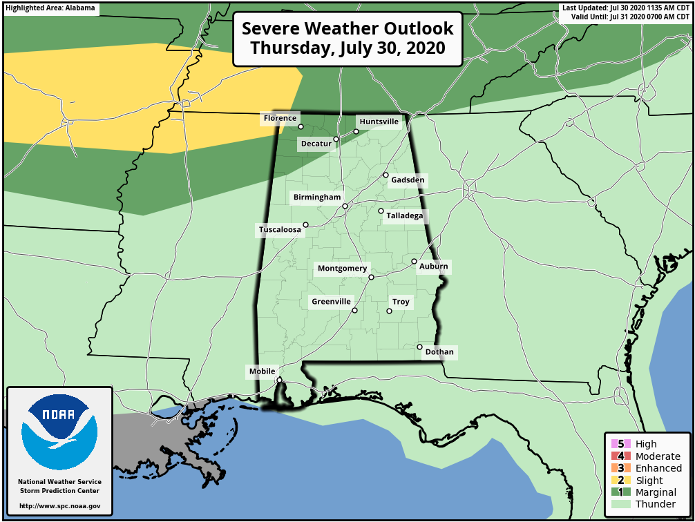
RADAR CHECK: Showers and thunderstorms continue to steadily increase across Alabama this afternoon in the moist, tropical air. They are moving quickly to the east which is limiting the amount of rain, and so far there hasn’t been much lightning activity. But we do note SPC has added a low end, “marginal risk” (level 1/5) of severe thunderstorms for Northwest Alabama this evening. A few storms there could produce strong gusty winds ahead of an upper trough.
Temperatures remain below average this afternoon with most communities in the mid to upper 80s. A few showers could linger into the late-night hours, but most will fade away by midnight.
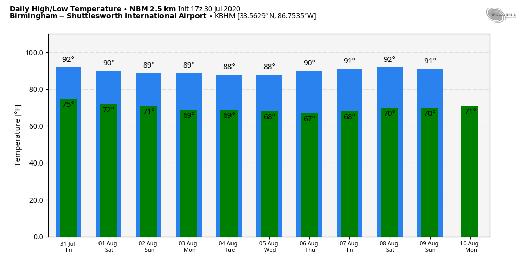
TOMORROW THROUGH THE WEEKEND: The weather won’t change much tomorrow and Saturday; look for a mix of sun and clouds both days with scattered showers and thunderstorms, most active from noon to midnight. A few strong storms are possible over the northern quarter of the state where SPC maintains a “marginal risk” both days. Highs will be in the 87 to 90 degree range for most places.
Showers become fewer in number Sunday as Alabama gets into an area of sinking air on the periphery of Tropical Storm Isaias, which should be just east of Jacksonville, Florida. The sky will be mostly sunny, and the high will remain between 87 and 90 degrees.
NEXT WEEK: Monday looks relatively dry with only isolated showers, but the rest of the week should feature typical summer weather. Partly sunny, hot, humid days with random, scattered, mostly afternoon and evening showers and thunderstorms. Highs will be very close to 90 degrees… See the Weather Xtreme video for maps, graphics, and more details.
TROPICAL STORM ISAIAS: The tropical storm has moved over Hispaniola today, and is in the process of reorganizing after passing through the mountainous island. The latest forecast track from NHC takes the system through the Bahamas, followed by a northward turn just off the East Coast of Florida over the weekend. Then, it runs northeast, very close to the U.S. Atlantic coast early next week.
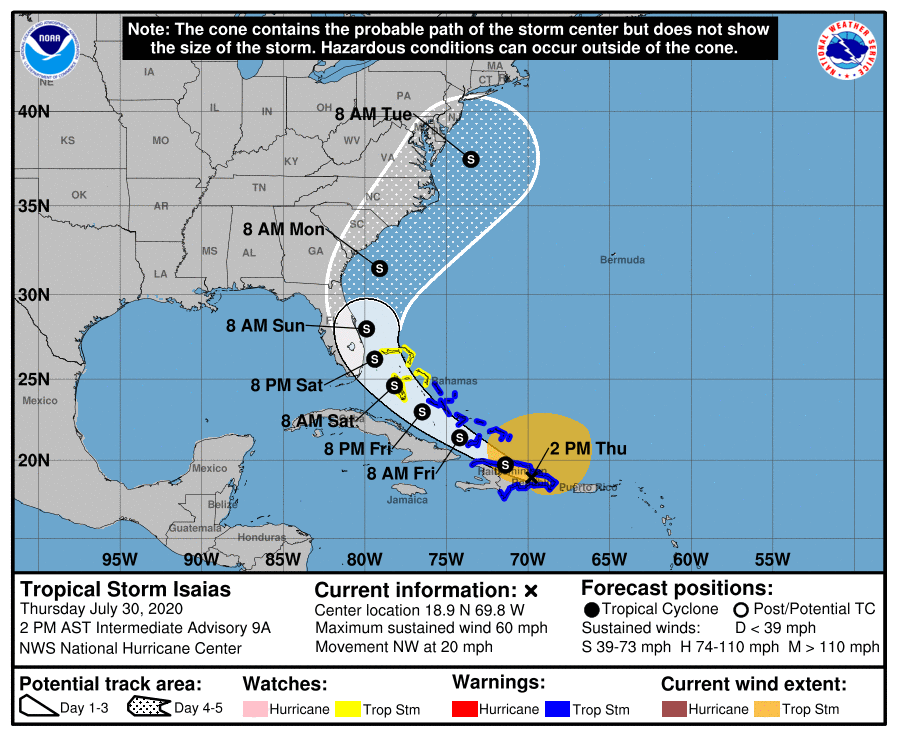
The intensity forecast remains challenging. As the system moves away from the Greater Antilles gradual strengthening is anticipated. The global models and the SHIPS guidance suggest that Isaias will encounter an area of moderate southwesterly shear over the weekend, and the NHC intensity forecast is again leveled off at that time. There are models that continue to suggest Isaias could become a hurricane when it is near the U.S. Everyone from Key West to Cape Cod will need to monitor the progress of Isaias in coming days.
There will be no impact in Alabama, or on the Central Gulf Coast (places like Gulf Shores, Pensacola, Destin, and Panama City Beach). For those planning a Disney trip to the Orlando area, the weekend will be breezy and showery, but the heaviest rain associated with Isaias should be east of there.
INVEST 93L: The next tropical wave has emerged off the coast of Africa in the far eastern Atlantic. Models are taking this one to the north, instead of the traditional westward motion, in the short term. If this one becomes a tropical storm, the name will be “Joesphine”.
ON THIS DATE IN 1970: Hurricane Celia was born in the northwest of the Caribbean Sea on this day. The hurricane would be one of the worst ever to hit Texas and would reach Texas late on August 3. The storm reached its peak as it made landfall near Corpus Christi, Texas, as a strong Category 3 hurricane. Hurricane Celia is currently the last major hurricane to make landfall on the middle Texas Coast until Hurricane Harvey in 2017.
BEACH FORECAST: Click here to see the AlabamaWx Beach Forecast Center page.
WEATHER BRAINS: Don’t forget you can listen to our weekly 90 minute show anytime on your favorite podcast app. This is the show all about weather featuring many familiar voices, including our meteorologists here at ABC 33/40.
CONNECT: You can find me on all of the major social networks…
Facebook
Twitter
Instagram
Pinterest
Snapchat: spannwx
Look for the next Weather Xtreme video here by 7:00 a.m. tomorrow…
Category: Alabama's Weather, ALL POSTS, Weather Xtreme Videos
About the Author (Author Profile)
James Spann is one of the most recognized and trusted television meteorologists in the industry. He holds the AMS CCM designation and television seals from the AMS and NWA. He is a past winner of the Broadcast Meteorologist of the Year from both professional organizations.Subscribe
If you enjoyed this article, subscribe to receive more just like it.


