

Isolated Showers Tomorrow, Otherwise Dry For Most Of The State For Several Days
RADAR CHECK: Strong thunderstorms persisted through the midday hours over Far East Alabama this afternoon ahead of a deep upper trough for summer. They produced hail in parts of Cherokee, Cleburne, and Calhoun counties earlier today. Most of those have moved over into Georgia, and for a large percentage of Alabama the sky is mostly sunny with temperatures close to 90 degrees this afternoon.
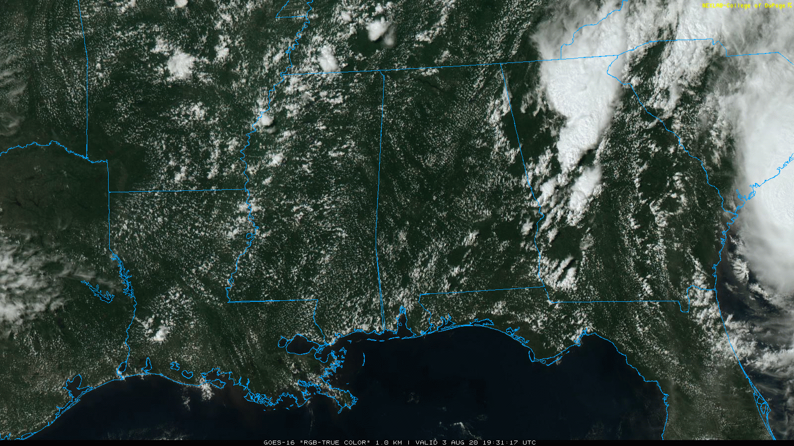
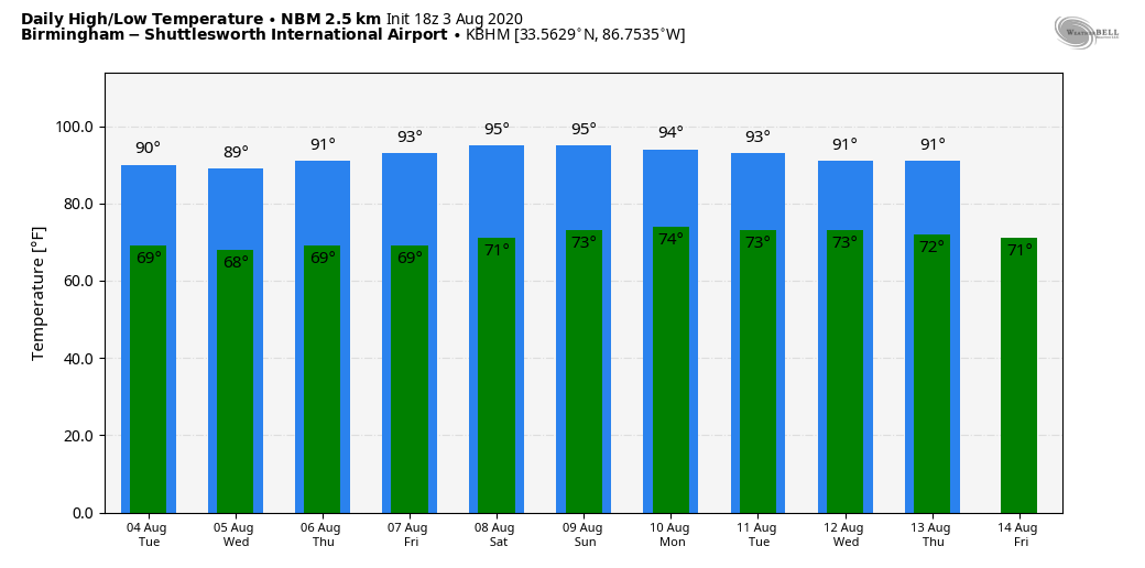
REST OF THE WEEK: We will keep the risk of a few isolated showers in place for tomorrow afternoon with the upper trough nearby, but most places will be dry with a partly sunny sky. The high tomorrow will be from 87 to 90 degrees for most communities. Then, for the rest of the week, the weather looks dry with lower precipitable water values. We expect mostly sunny days and fair nights Wednesday through Friday with highs around 90, and lows down in the 60s. Humidity values will be a bit lower than usual for August in Alabama.
THE ALABAMA WEEKEND: For now we are going to leave showers out of the forecast as the unusually dry airmass holds in place. Expect a good supply of sunshine Saturday and Sunday; heat levels will rise a bit with highs in the low to mid 90s.
NEXT WEEK: The risk of rain remains very low Monday and Tuesday, but global models show higher moisture levels over the latter half of the week, and we will bring back the chance of scattered, mostly afternoon and evening showers and thunderstorms Wednesday through Friday. See the Weather Xtreme video for maps, graphics, and more details.
ISAIAS ROLLING NORTHEAST: Tropical Storm Isaias will move into the coast of the Carolinas this evening; winds are 70 mph as I write this. The system will continue to move northeast, right up the I-95 corridor, over the next 48 hours.
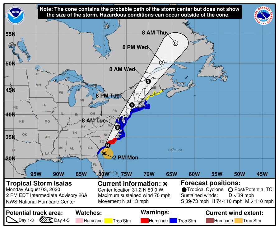
There is the danger of life-threatening storm surge inundation along portions of the immediate coastline and adjacent waterways of northeastern South Carolina and the North Carolina coast in the Storm Surge Warning area. Residents in these areas should follow advice given by local emergency officials.
Isaias is expected to bring widespread sustained tropical storm force winds and wind gusts to hurricane force to the mid-Atlantic coast tomorrow, which could cause tree damage and power outages. Tropical storm conditions are expected to reach southern New England tomorrow evening and are possible along the northern New England coast tomorrow night and early Wednesday.
Heavy rainfall will result in flash and urban flooding, some of which may be significant in the eastern Carolinas and the mid-Atlantic, through Tuesday night near the path of Isaias up the East Coast of the United States. Widespread minor to moderate river flooding is possible across portions of the Carolinas and the Mid-Atlantic.
INVEST 94L: A disturbance south of Bermuda has a medium chance of becoming a tropical depression or storm over the next 48 hours; models suggest steering currents will collapse, and that system just might hang around the same place for 3-5 days. For now it doesn’t seem to be a threat to the U.S.
The rest of the Atlantic basin is quiet.
ON THIS DATE IN 1970: Hurricane Celia made landfall near Port Aransas, Texas as a major Hurricane, Category 3 on the Saffir-Simpson scale with sustained winds of 130 mph. It was the costliest tropical cyclone in Texas history until Hurricane Alicia in 1983. Throughout the state, 8,950 homes were destroyed and damaged about 55,650 others. About 252 small businesses, 331 boats, and 310 farm buildings were either damaged or destroyed. Impact was the worst in Nueces County, which observed gusts as high as 180 mph. In Corpus Christi, about one-third of houses suffered severe damage or were destroyed. Additionally, about 90% of the buildings in downtown were damaged to some degree. Celia weakened as it continued further inland and dissipated over New Mexico on August 6.
BEACH FORECAST: Click here to see the AlabamaWx Beach Forecast Center page.
WEATHER BRAINS: Don’t forget you can listen to our weekly 90 minute show anytime on your favorite podcast app. This is the show all about weather featuring many familiar voices, including our meteorologists here at ABC 33/40.
CONNECT: You can find me on all of the major social networks…
Facebook
Twitter
Instagram
Pinterest
Snapchat: spannwx
Look for the next Weather Xtreme video here by 7:00 a.m. tomorrow…
Category: Alabama's Weather, ALL POSTS, Weather Xtreme Videos
About the Author (Author Profile)
James Spann is one of the most recognized and trusted television meteorologists in the industry. He holds the AMS CCM designation and television seals from the AMS and NWA. He is a past winner of the Broadcast Meteorologist of the Year from both professional organizations.Subscribe
If you enjoyed this article, subscribe to receive more just like it.


