Very Few Showers Today/Tomorrow; Eyes On The Tropics
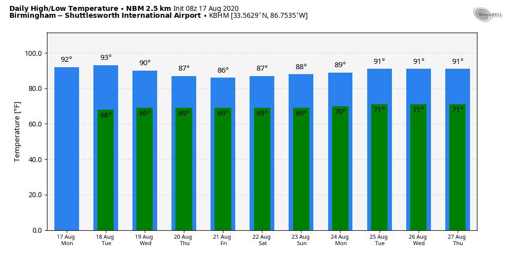
ONLY ISOLATED SHOWERS THROUGH TOMORROW: A relatively dry airmass overs Alabama this morning, meaning showers should be few and far between across the state over the next 48 hours. Odds of any one spot getting wet over the northern half of the state today and tomorrow are only 10-15 percent, otherwise looks for mostly sunny days and fair nights with highs close to 90 degrees. The average high for Birmingham on August 17 is 91.
Moisture levels will rise a bit over the latter half of the week, and we will have the typical chance of random, scattered, mostly afternoon and evening showers and thunderstorms Wednesday through Friday. The sky will be partly sunny each day with highs between 87 and 90 degrees, below average for August in Alabama. Chance of any one spot getting wet each day will be 30-50 percent, and most of the showers and storms will come from 1:00 until 9:00 p.m.
THE ALABAMA WEEKEND: Not much change; we expect a mix of sun and clouds Saturday and Sunday with scattered showers and thunderstorms, mostly during the afternoon and evening hours. Highs will hold in the 87 to 90 degree range.
NEXT WEEK: We will go with a summer persistence forecast, but there is a decent chance a tropical system will be involved. It is simply too early to know if it will bring any enhanced risk of rain to Alabama, or provide a drier pattern. Highs will be in the low 90s most days, close to seasonal averages. See the Weather Xtreme video for maps, graphics, and more details.
TROPICS: Tropical storms Kyle and Josephine dissipated over the weekend with no impact to land. But, now NHC is monitoring two tropical waves in the MDR (main development region) of the Atlantic basin, and both are expected to develop.
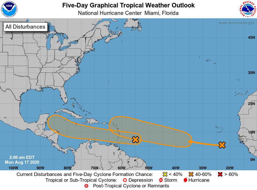
One wave is located over the far eastern tropical Atlantic well to the south-southeast of the Cabo Verde Islands, and is producing a large area of cloudiness and disorganized showers. The wave is forecast to move westward to west-northwestward at 15 to 20 mph during the next few days, and environmental conditions are expected to become more conducive for the development of a tropical depression during the middle-to-latter part of this week while the system moves across the central tropical Atlantic.
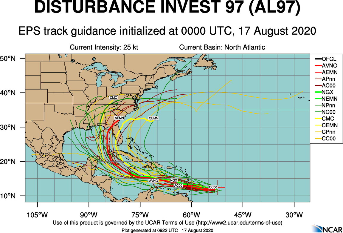
The other one, now Invest 97L, is fast-moving tropical wave located about 400 miles east of the Windward Islands continues to produce disorganized shower and thunderstorm activity. This disturbance is expected to move westward at about 20 mph during the next few days, and that fast forward speed is likely to limit significant development while the system approaches the Windward and southern Leeward Islands today, and moves across the eastern and central Caribbean Sea tomorrow and Wednesday. After that time, however, the system is expected to move more slowly westward across the western Caribbean Sea, where upper-level winds could become more conducive for the development of a tropical depression during the latter part of this week. Regardless of development, locally heavy rainfall and gusty winds are expected over portions of the Windward and southern Leeward Islands beginning this evening through Tuesday morning.
Model guidance suggests 97L will ultimately enter the Gulf of Mexico at some point over the coming weekend, but it is way too early to know the final destination, or intensity. Simply something to watch for now. But, it sure looks like the Atlantic basin is about to come alive as we head into the peak of the hurricane season.
ON THIS DATE IN 1969: Hurricane Camille made landfall along the Mississippi Gulf Coast near Waveland, MS. Camille is one of only FOUR Category 5 hurricanes ever to make landfall in the continental United States – the others being the 1935 Labor Day Hurricane, which impacted the Florida Keys; Hurricane Andrew in 1992, which impacted south Florida; and Hurricane Michael in 2018, which impacted the Florida panhandle. (Note: It is worth mentioning that the 1928 San Felipe Hurricane made landfall as a Category 5 Hurricane on Puerto Rico)
Camille ranks as the 2nd most intense hurricane to strike the continental US with 900 mb pressure and landfall intensity of 150 knots. Camille ranks just below the 1935 Labor Day Hurricane with 892 mb and 160 knots, while slightly stronger than Hurricane Andrew with 922 mb and 145 knots and Hurricane Michael with 919 mb and 140 knots. The actual maximum sustained winds of Hurricane Camille are not known as the hurricane destroyed all the wind-recording instruments in the landfall area. Re-analysis data found peak winds of 150 knots (roughly 175 mph) along the coast. A devastating storm tide of 24.6 feet occurred in Pass Christian, MS. The death toll was 256.
BEACH FORECAST: Click here to see the AlabamaWx Beach Forecast Center page.
WEATHER BRAINS: Don’t forget you can listen to our weekly 90 minute show anytime on your favorite podcast app. This is the show all about weather featuring many familiar voices, including our meteorologists here at ABC 33/40.
CONNECT: You can find me on all of the major social networks…
Facebook
Twitter
Instagram
Pinterest
Snapchat: spannwx
Look for the next Weather Xtreme video here by 4:00 this afternoon… enjoy the day!
Category: Alabama's Weather, ALL POSTS, Weather Xtreme Videos
About the Author (Author Profile)
James Spann is one of the most recognized and trusted television meteorologists in the industry. He holds the AMS CCM designation and television seals from the AMS and NWA. He is a past winner of the Broadcast Meteorologist of the Year from both professional organizations.Subscribe
If you enjoyed this article, subscribe to receive more just like it.


