Sally To Bring A Big Soaking To Alabama
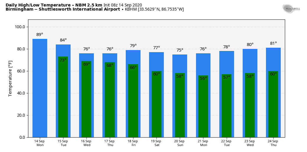
SCATTERED SHOWERS LATER TODAY: The radar is quiet across most of Alabama early this morning, but we expect scattered showers, and possibly a thunderstorm to form this afternoon and tonight. Odds of any one spot getting wet are 30/35 percent, and the high today will be in the upper 80s with a partly sunny sky.
MID-WEEK: The sky becomes mostly cloudy, and showers will form during the day as Sally moves into the Mississippi coast. Then, rain become widespread and heavy at times tomorrow night and Wednesday as Sally begins to turn to the east/northeast and into Alabama. Rain amounts of 3 to 6 inches are expected for North/Central Alabama, and a flash flood watch has been issued. Rain will diminish by Thursday morning as the remnant circulation moves to the east.
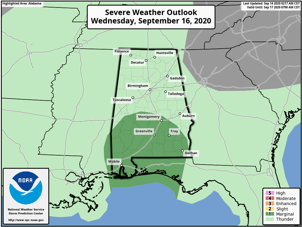
Wednesday will be breezy, with average winds of 15-25 mph along with gusts to 30 mph. There is a low end, conditional risk of a few brief, isolated tornadoes over the southern half of the state as well; SPC has a “marginal risk” defined for areas generally along and south of U.S. 80.
FRIDAY AND THE WEEKEND: The weather looks delightful on these three days. Lots of sunshine, lower humidity, and cool nights. Highs will be only in the 78-82 degree range, with lows not too far from 60 degrees. It will really feel like fall.
NEXT WEEK: And, the great weather will likely persist through much of next week with pleasant days and cool nights. Most of the week is looking rain-free… See the Weather Xtreme video for maps, graphics, and more details.
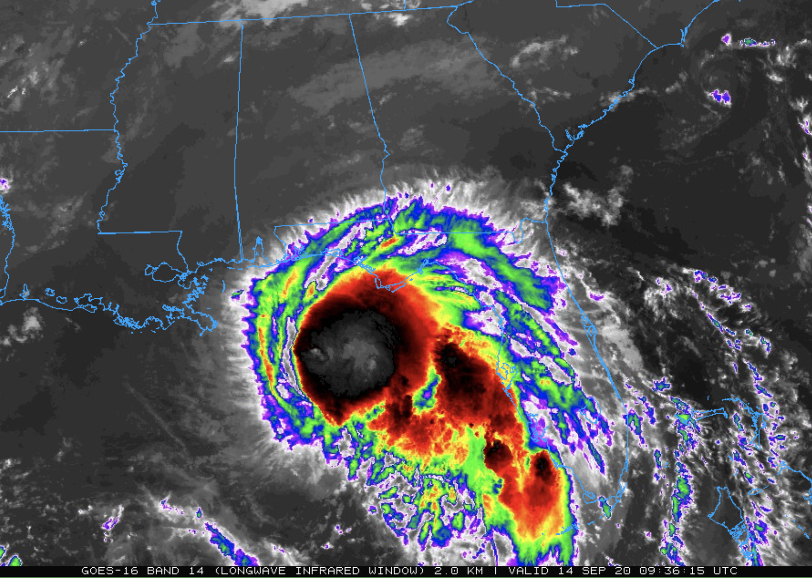
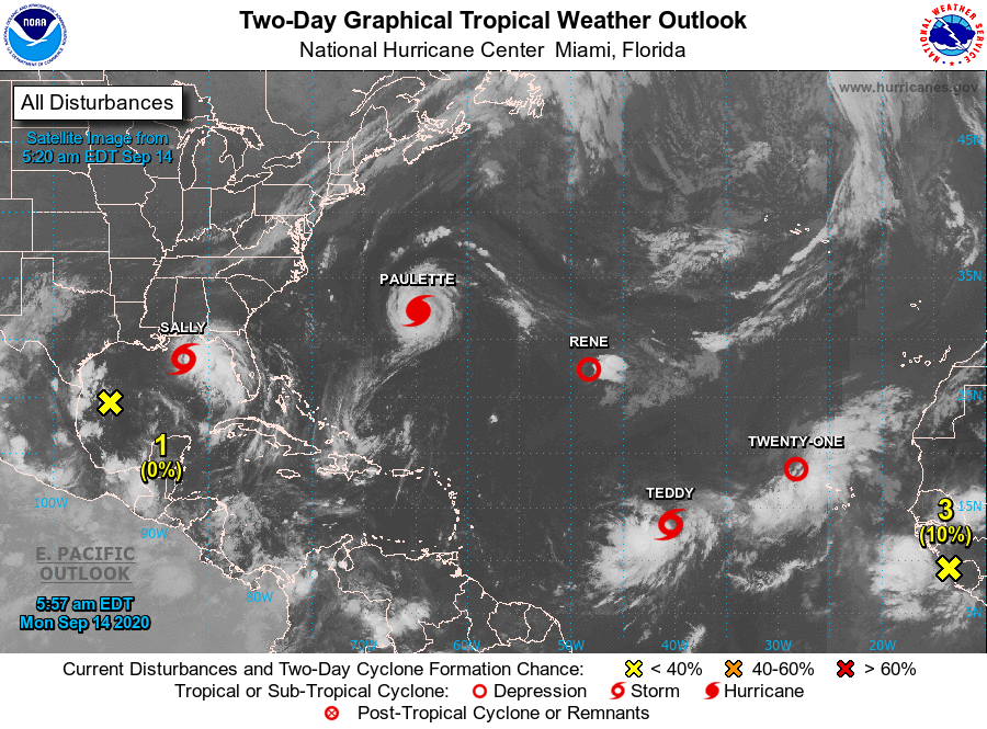
SALLY: Tropical Storm Sally is about 175 miles southeast of Biloxi, Mississippi this morning with winds of 60 mph…. moving west/northwest at 9 mph. NHC is forecasting Sally to become a category one hurricane later today, it will be near the mouth of the Mississippi River late tonight. From there it slows down and turns north, and moves into the Mississippi coast tomorrow afternoon.
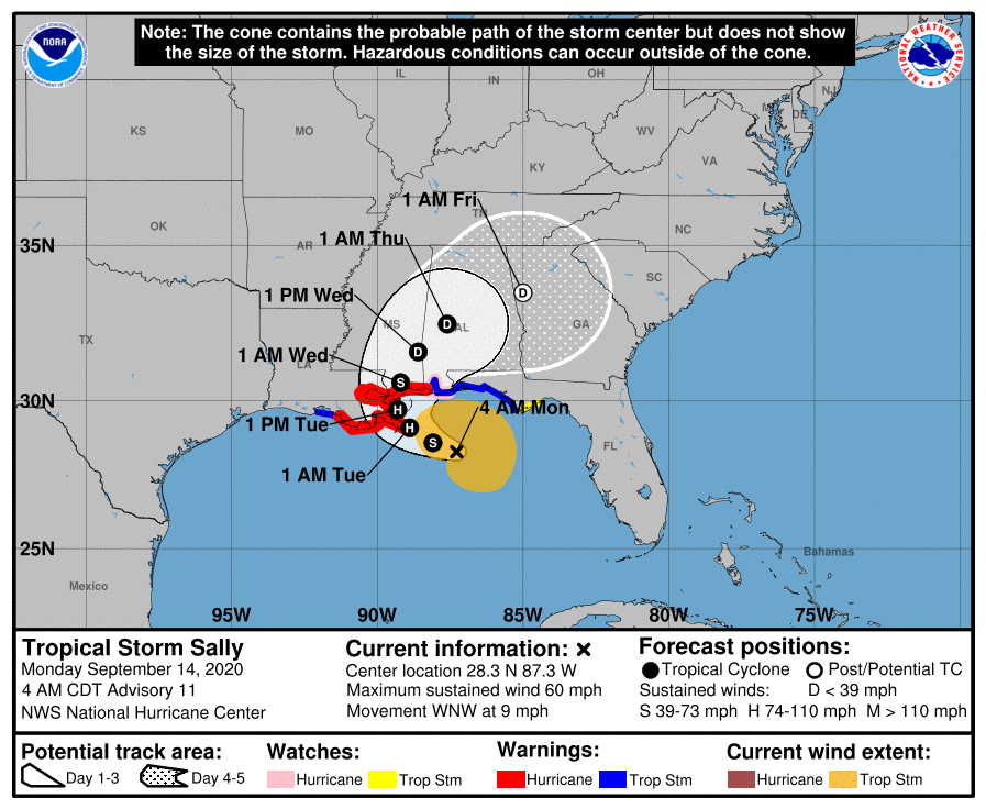
The remnant circulation will turn move east/northeast into Central Alabama Wednesday night. Don’t focus on the details of the official forecast track, since NHC’s average forecast error at 48 hours is around 80 miles, and dangerous storm surge, rainfall, and wind hazards will extend well away from the center.
Storm surge for the Alabama Gulf Coast and Mobile Bay is forecast to be 4 to 6 feet.Sustained winds of 30-50 mph are likely along the Alabama Gulf Coast tonight and tomorrow, with gusts to 70 mph possible. Sustained winds from Pensacola Beach to Panama City Beach will be 20-40 mph, with gusts to 50 mph possible. Rain amounts of 10-24 inches is forecast for the Alabama Gulf Coast, as well as the rest of Mobile and Baldwin counties. Of course, dangerous rip currents are likely, and a few waterspouts and brief tornadoes are possible as well on the coast.
ELSEWHERE IN THE TROPICS: Hurricane Paulette, with winds of 90 mph, is right on top of Bermuda this morning. It will then turn out to sea; no impact on the U.S. Tropical Storm Teddy in the Atlantic is expected to become a major hurricane late this week, but it will move north, and then northeast without impacting the U.S. or the Lesser Antilles. Tropical Depression Rene is dissipating, and newly formed Tropical Depression 21 in the eastern Atlantic is expected to be short lived.
ON THIS DATE IN 2008: Hurricane Ike became extratropical on this day. The St. Louis Metropolitan Area experienced hurricane conditions, with Ike’s remnants inflicting severe damage to homes. Several areas in Illinois and Indiana, already flooded by the frontal boundary to the north, saw significant additional rainfall. Due to flooding in Chicago, a state of emergency was declared for Cook County due to flooding of the Des Plaines River. Hurricane-force wind gusts were reported to the east of the center across parts of Kentucky, Indiana, Ohio, and Pennsylvania with significant wind damage including structural damage to buildings and trees.
BEACH FORECAST: Click here to see the AlabamaWx Beach Forecast Center page.
WEATHER BRAINS: Don’t forget you can listen to our weekly 90 minute show anytime on your favorite podcast app. This is the show all about weather featuring many familiar voices, including our meteorologists here at ABC 33/40.
CONNECT: You can find me on all of the major social networks…
Facebook
Twitter
Instagram
Pinterest
Snapchat: spannwx
Look for the next Weather Xtreme video here by 4:00 this afternoon… enjoy the day!
Category: Alabama's Weather, ALL POSTS, Weather Xtreme Videos
About the Author (Author Profile)
James Spann is one of the most recognized and trusted television meteorologists in the industry. He holds the AMS CCM designation and television seals from the AMS and NWA. He is a past winner of the Broadcast Meteorologist of the Year from both professional organizations.Subscribe
If you enjoyed this article, subscribe to receive more just like it.


