Lingering Light Rain Ends Soon; Dry Days Ahead
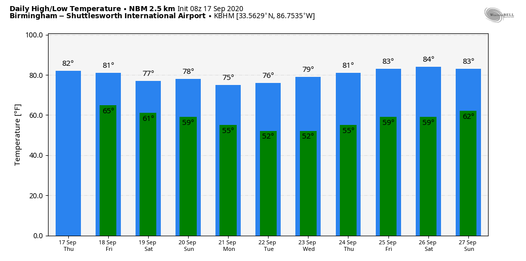
RADAR CHECK: We have some lingering light rain over parts of East and Central Alabama early this morning, but the main rain shield associated with the remnant circulation of Sally is over Georgia and the Carolinas. Rain will end this morning, and the sky becomes partly sunny this afternoon with a high in the low 80s. The average high for September 17 at Birmingham is 85.
TOMORROW THROUGH THE WEEKEND: For most of the state, the weather will be dry. Partly sunny tomorrow with a high in the low 80s, then we expect highs in the upper 70s over the weekend with lows between 59 and 63. The sky will be partly to mostly sunny over the weekend, and any showers will be confined to the southern quarter of the state, and even there they will be pretty isolated.
NEXT WEEK: Fall weather fans will love it. Sunny comfortable days, clear cool nights through the week. Highs in the 70s Monday through Wednesday, followed by low 80s Thursday and Friday. Lows will be in the 50s most of the week… some of the cooler spots could reach the upper 40s for the first time this season over North Alabama early Tuesday and Wednesday morning. See the Weather Xtreme video for maps, graphics, and more details.
YESTERDAY’S RAIN: Some rain totals across the region yesterday included…
Pensacola 18.77″
Hurlburt Field 13.20″
Fairhope 10.42″
Troy 7.35″
Brewton 5.24″
Montgomery 3.60″
Mobile 3.17″
Weaver 1.17″
Jemison 0.92″
Rainbow City 0.72″
Mountain Brook 0.19″
Crestwood 0.15″
Birmingham 0.04″
Hueytown 0.01″
Parts of West and Northwest Alabama had no rain at all from Sally.
TROPICS: The center of Tropical Depression Sally this morning is about 50 miles southeast of Montgomery; it moves into Georgia soon and will become a remnant low today. Elsewhere, Tropical Storm Vicky in the Atlantic is expected to dissipate soon and is no threat to land. Teddy is expected to reach major hurricane status tonight; it will weaken a bit by Sunday night, and will be very close to Bermuda Monday. From there is turns northeast out to sea and is no threat to the U.S.
Invest 98L in the far eastern Atlantic should become a tropical storm in a few days, but most likely it recurves and won’t impact any land areas.
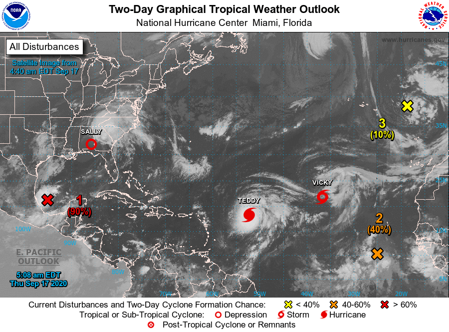
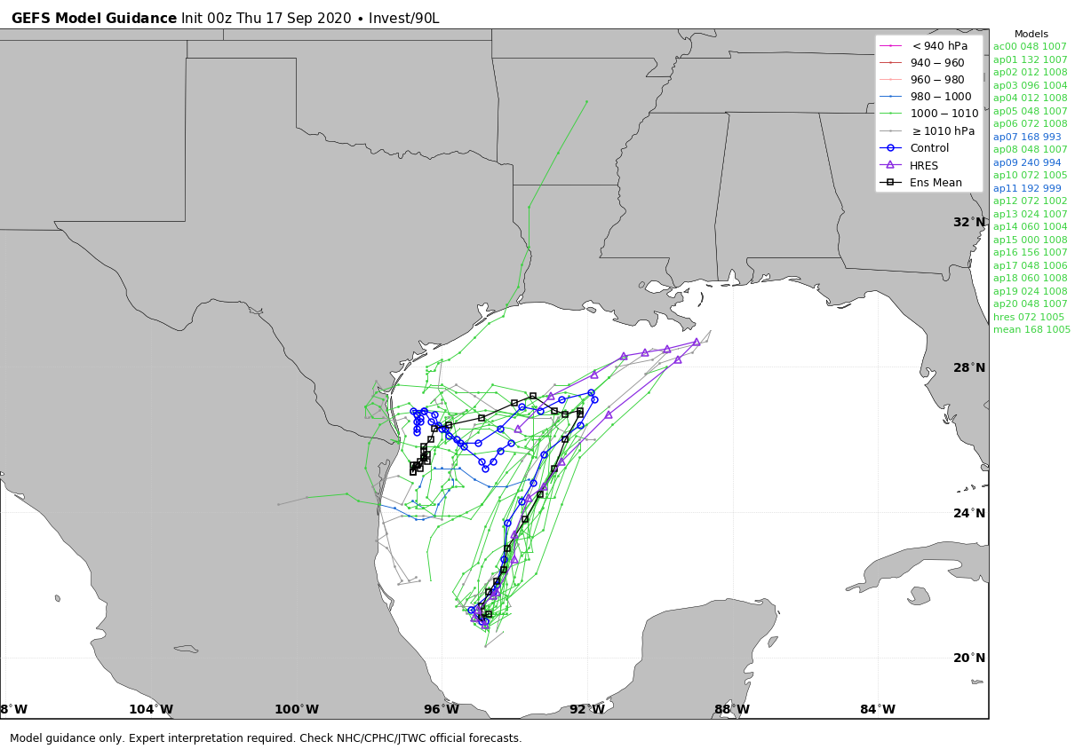
Closer to home, Invest 90L in the Southwest Gulf of Mexico has a high chance of becoming a tropical depression or storm over the next five days. Models suggest it will drift northward before turning west, toward either the southern tip of Texas or Mexico. The forecast upper air pattern suggests this won’t be a threat to the Central Gulf Coast.
ON THIS DATE IN 1989: Hurricane Hugo hit the Virgin Islands, producing wind gusts to 97 mph at Saint Croix. Hurricane Hugo passed directly over the island of Saint Croix causing complete devastation and essentially cutting off the island from communications. A storm surge of five to seven feet occurred at Saint Croix. The only rain gauge left operating, at Caneel Bay, indicated 9.40 inches in 24 hours. Hurricane Hugo claimed the lives of three persons at Saint Croix and caused more than 500 million dollars damage. The hurricane could strike the South Carolina coast a few days later.
BEACH FORECAST: Click here to see the AlabamaWx Beach Forecast Center page.
WEATHER BRAINS: Don’t forget you can listen to our weekly 90 minute show anytime on your favorite podcast app. This is the show all about weather featuring many familiar voices, including our meteorologists here at ABC 33/40.
CONNECT: You can find me on all of the major social networks…
Facebook
Twitter
Instagram
Pinterest
Snapchat: spannwx
Look for the next Weather Xtreme video here by 4:00 this afternoon… enjoy the day!
Category: Alabama's Weather, ALL POSTS, Weather Xtreme Videos
About the Author (Author Profile)
James Spann is one of the most recognized and trusted television meteorologists in the industry. He holds the AMS CCM designation and television seals from the AMS and NWA. He is a past winner of the Broadcast Meteorologist of the Year from both professional organizations.Subscribe
If you enjoyed this article, subscribe to receive more just like it.


