Much Cooler Air Moves Into Alabama Tonight
ON THE MAP: A cold front is pushing through Northwest Alabama this afternoon, setting up a big thermal contrast across the state. At 2p CT, Tuscaloosa reported 86 degrees, but on the other side of the front Haleyville was at a cool 63 degrees, making for a 24 degree swing on either side of the boundary. Showers and a few strong thunderstorms are along the front; heavier storms will be capable of producing strong gusty winds, but the overall severe weather threat is low this afternoon.
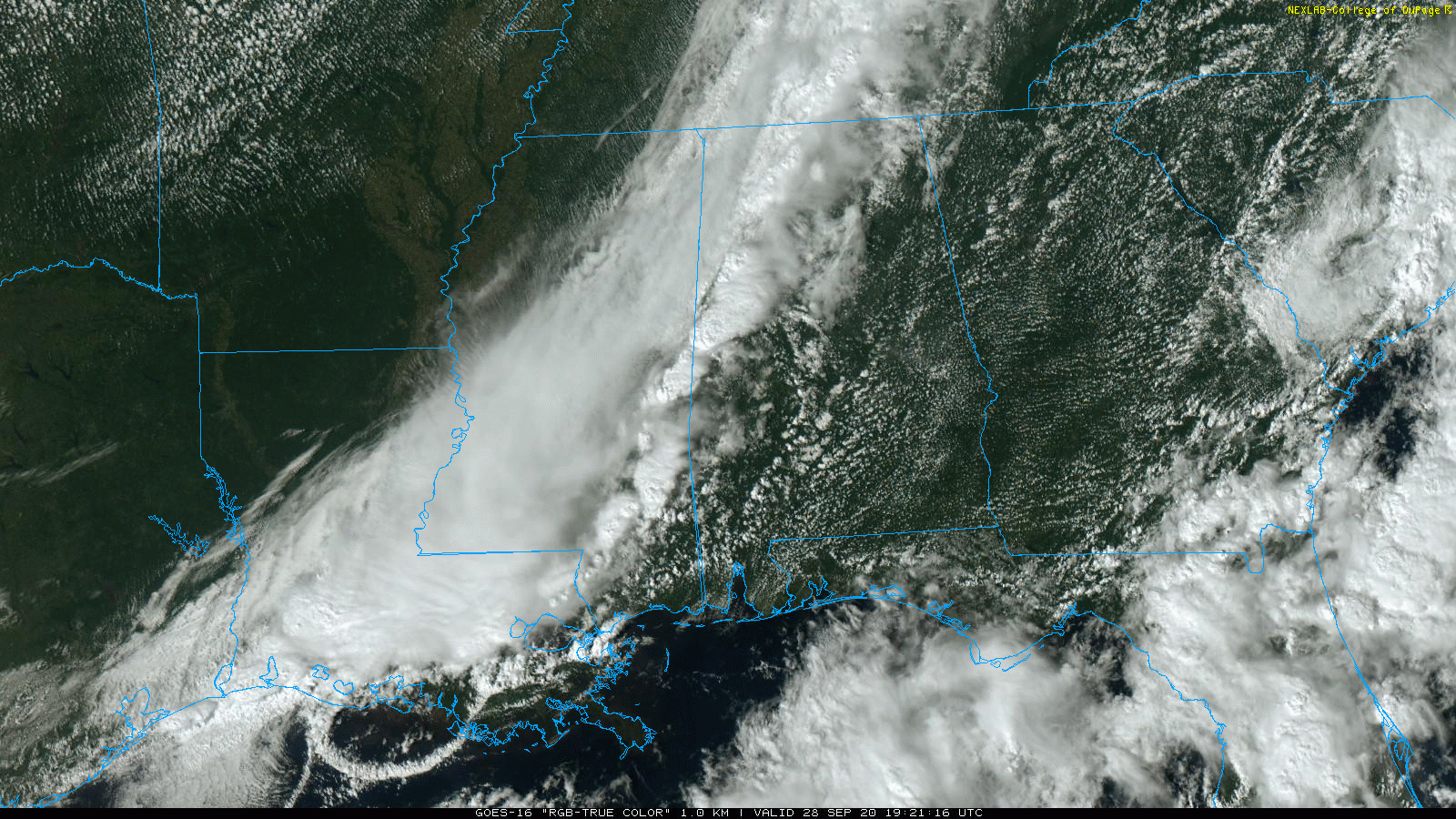
Showers and storms will push out of Alabama tonight as the cold front continues on to the east.
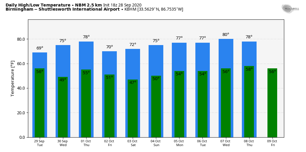
Tomorrow will be a different kind of day; a deep upper trough will likely keep clouds over the northern half of Alabama much of the day, and a little patchy light rain or drizzle will be possible. Temperatures won’t get out of the 60s over the northern third of the state; highs will be in the low to mid 70s elsewhere.
WEDNESDAY THROUGH FRIDAY: Look for sunny pleasant days and clear cool nights. Highs will be in the mid 70s Wednesday and Thursday, but a new surge of cooler air arrives Friday as the high drops into the 68-72 degree range. Lows will be in the 40s and 50s.
THE ALABAMA WEEKEND: Saturday morning will be cold; some of the traditionally colder valleys could reach the upper 30s across North Alabama. The day will be sunny with a high in the low to mid 70s. Then, on Sunday, the latest global models show an upper trough swinging through; that feature could bring a few isolated showers to North Alabama. Otherwise we expect a mix of sun and clouds Sunday with a high between 70 and 75 degrees.
NEXT WEEK: The week looks mostly dry as the pleasant fall weather continues. Mostly sunny days, clear cool nights. Highs mostly in the 70s, lows mostly in the 50s. See the Weather Xtreme video for maps, graphics, and more details.
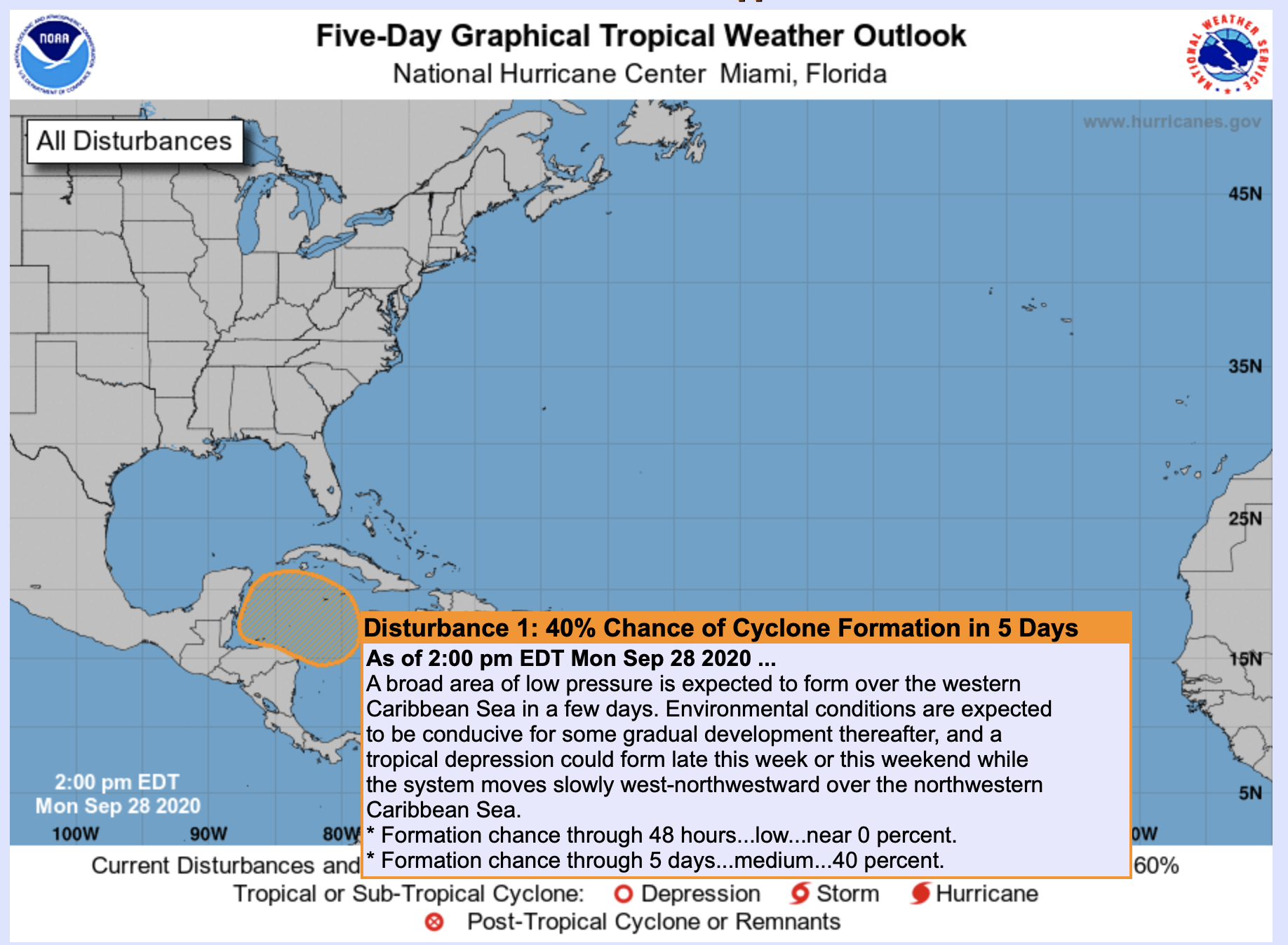
TROPICS: The Atlantic basin is very quiet this afternoon, but NHC has defined a medium chance of a tropical depression forming in the Northwest Caribbean late this week or over the weekend. If a tropical cyclone forms, it could drift into Central America, or northward in the direction of the Gulf of Mexico.
ON THIS DATE IN 1998: Hurricane Georges made landfall near Biloxi, Mississippi with maximum winds of 110 mph and a minimum pressure of 964 mb, making it a Category 2 hurricane. Georges produced a 7-12 foot storm surge in Mobile and Baldwin Counties with a 5-10 foot storm surge across the western Florida Panhandle, which caused extensive damage across coastal communities. The surge on the west end of Dauphin Island caused the most damage across the area. 80 houses were damaged on Dauphin Island and nearly 40 were completely destroyed. Many gulf front homes on the west end of the island were pushed across the island and ended up either against other homes or scattered across the sand.
BEACH FORECAST: Click here to see the AlabamaWx Beach Forecast Center page.
WEATHER BRAINS: Don’t forget you can listen to our weekly 90 minute show anytime on your favorite podcast app. This is the show all about weather featuring many familiar voices, including our meteorologists here at ABC 33/40.
CONNECT: You can find me on all of the major social networks…
Facebook
Twitter
Instagram
Pinterest
Snapchat: spannwx
Look for the next Weather Xtreme Video here by 7:00 a.m. tomorrow…
Category: Alabama's Weather, ALL POSTS, Weather Xtreme Videos
About the Author (Author Profile)
James Spann is one of the most recognized and trusted television meteorologists in the industry. He holds the AMS CCM designation and television seals from the AMS and NWA. He is a past winner of the Broadcast Meteorologist of the Year from both professional organizations.Subscribe
If you enjoyed this article, subscribe to receive more just like it.


