High Impact Wind Event For Alabama Tonight
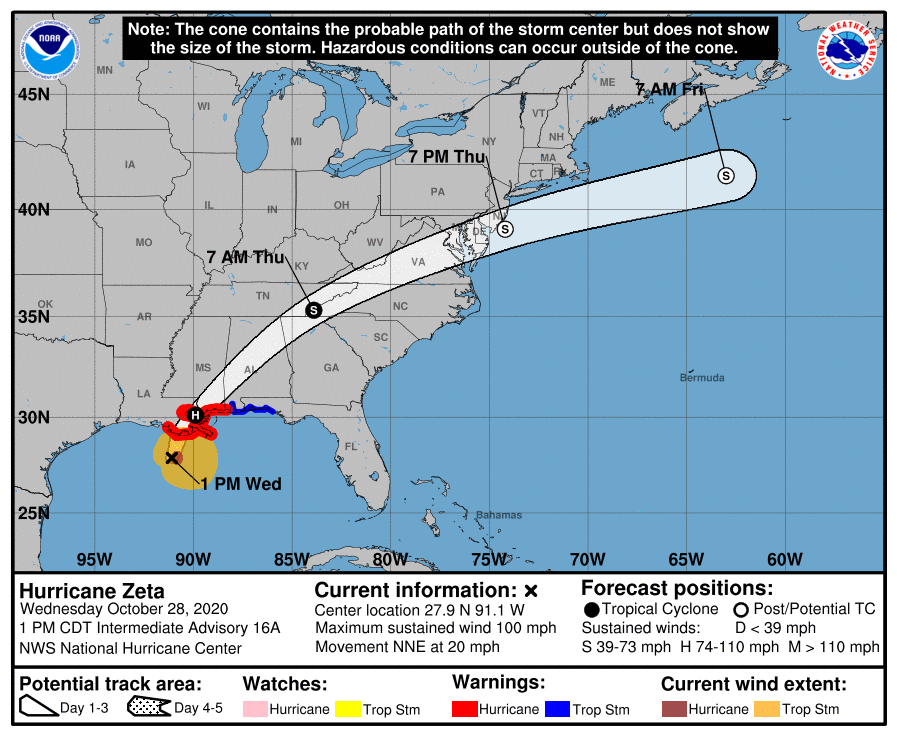
ZETA NEARING LANDFALL: Hurricane Zeta, despite cooler shelf water and strong winds aloft, doesn’t want to weaken this afternoon. Sustained winds are 110 mph, and landfall comes shortly across Southeast Louisiana. The core remnant circulation will race through Alabama tonight.
ON THE COAST: Winds could gust to 90 mph over parts of Mobile County tonight; gusts to 75 mph are possible over Baldwin County. The storm surge on Dauphin Island is forecast to be 6-9 feet; a surge of 4-6 feet is expected for Mobile Bay, and 3-5 feet along the beaches of southern Baldwin County (Fort Morgan to Orange Beach).
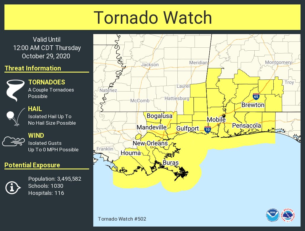
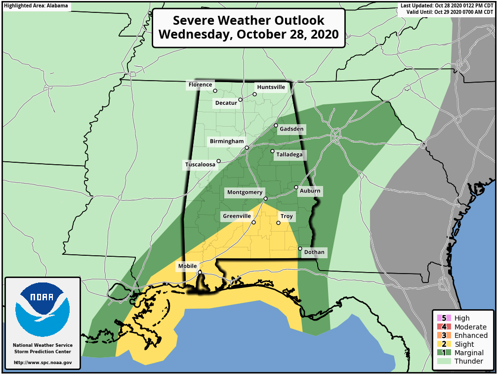
A tornado watch is in effect for Southwest Alabama until midnight; a few isolated tornadoes and waterspouts are possible.
Rain amounts of 2-3 inches are likely on the Alabama Gulf Coast through tomorrow; a flash flood watch is in effect.
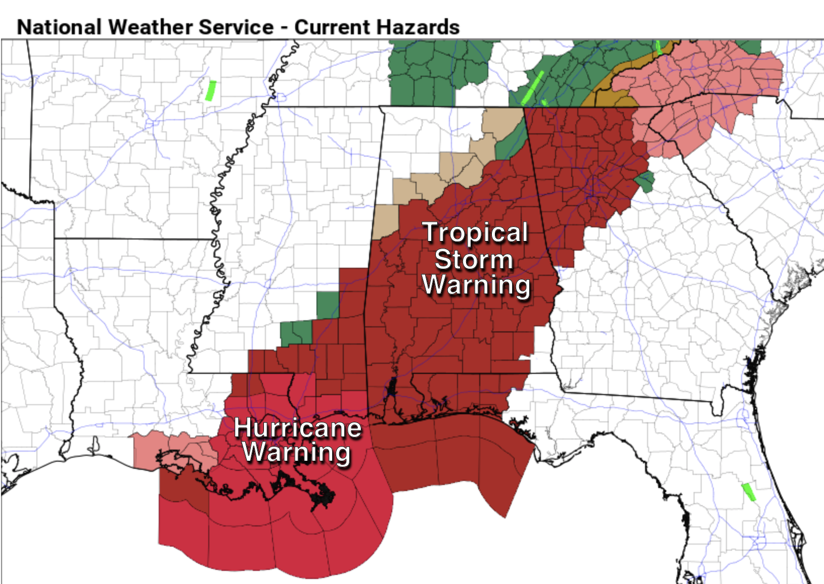
INLAND ALABAMA: A tropical storm warning is in effect for a large part of Alabama tonight as Zeta races through the state. There is potential for a high impact wind event with widespread tree and power line damage; expect numerous power outages tonight.
*For those in the tropical storm warning, expect sustained winds of 25-45 mph, with gusts to 65 mph.
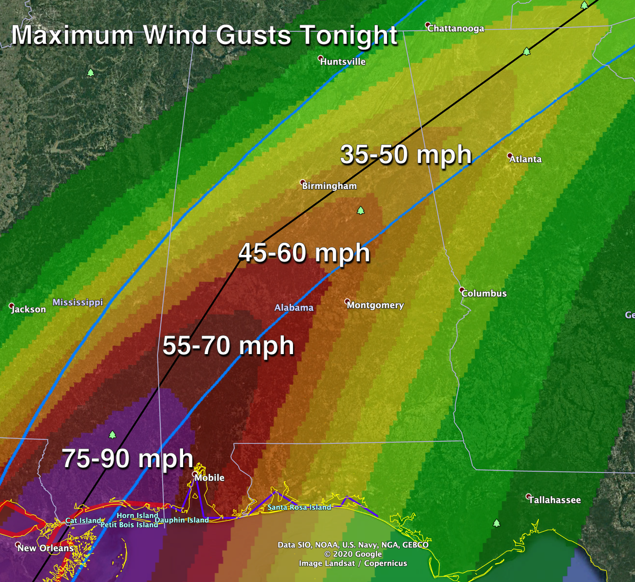
For most of Central and East Alabama, the highest winds will come after midnight.
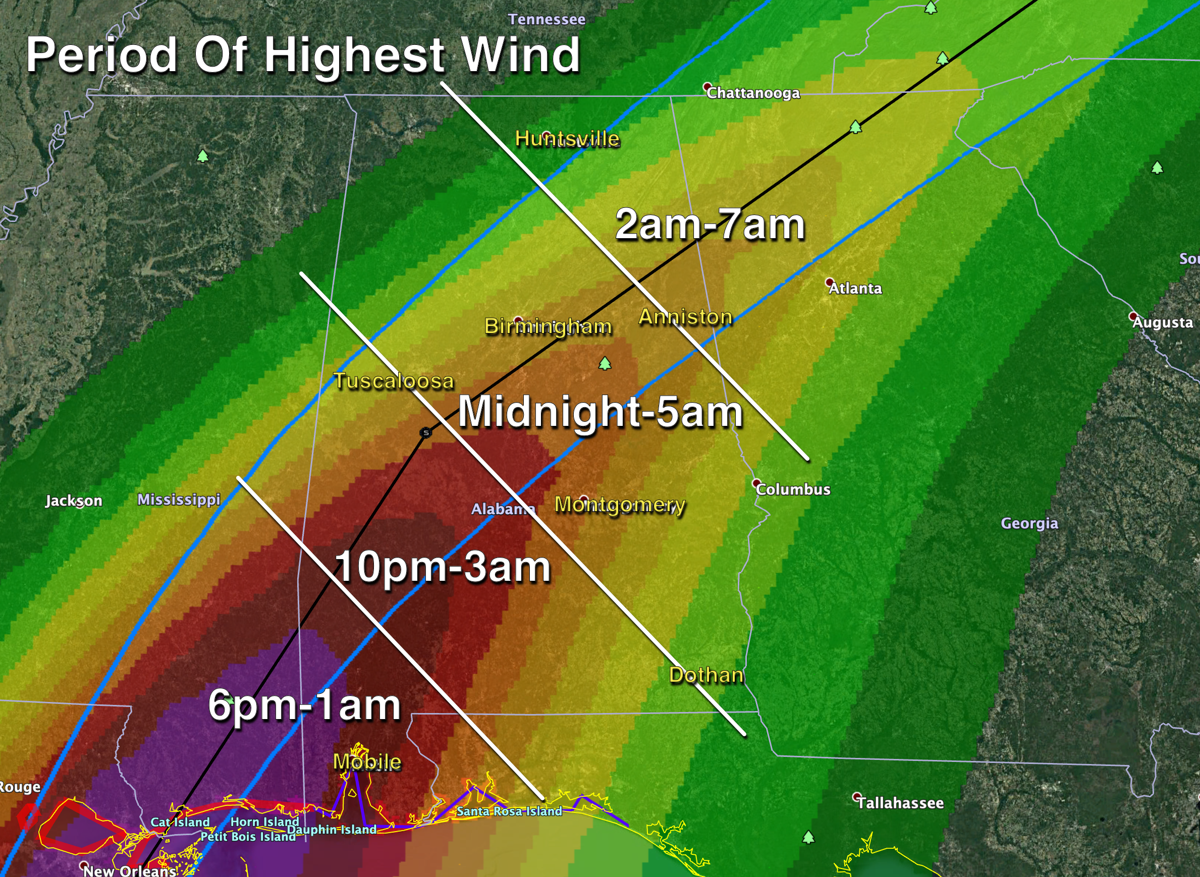
*For any one spot, the highest winds will last about 2-3 hours.
*The greatest concern will come from falling trees late tonight and during the pre-dawn hours tomorrow. If you live in a mobile home surrounded by pine trees, I would consider spending the night in a different place tonight.
*Plan now for power outages. Secure loose objects on your property.
*A few brief, isolated tornados are possible over East and South Alabama.
*Rain amounts over the next 24 hours will be in the 1-3 inch range; a flash flood watch is in effect for much of Alabama.
*The wind and the rain will subside early tomorrow morning, and the sky becomes partly sunny during the day tomorrow.
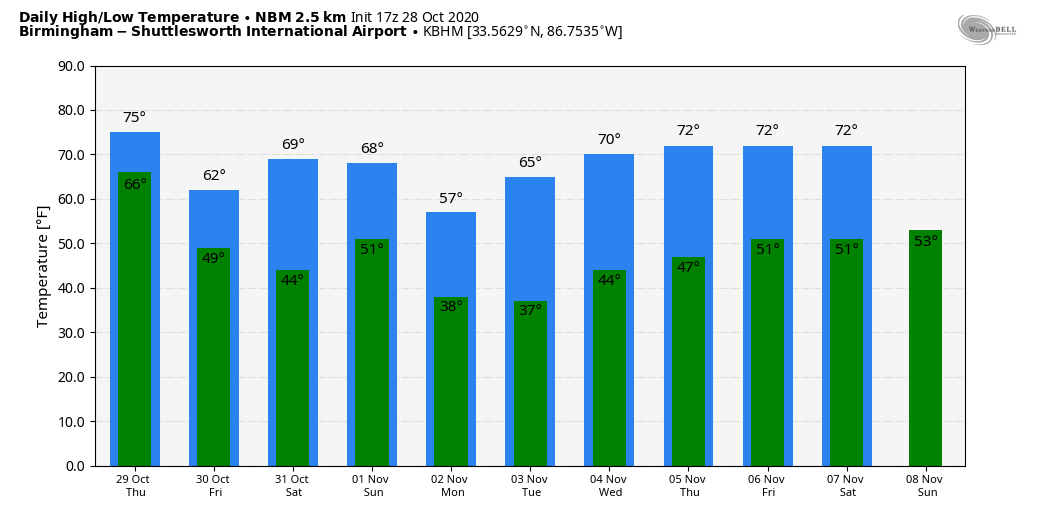
FRIDAY AND THE WEEKEND: Friday will be mostly sunny and cooler with a high in the 60s; dry weather continues into the Halloween weekend with a good supply of sunshine both Saturday and Sunday. The high both days will be in the 68-72 degree range.
NEXT WEEK: Colder air arrives early in the week; highs drop into the upper 50s Monday, and lows will be in the 30s both Monday and Tuesday morning. Widespread frost looks likely early Tuesday, with potential for a freeze in the colder spots. We warm back into the low 70s by Thursday and Friday, and for now the week looks rain-free. See the Weather Xtreme video for maps, graphics, and more details.
ON THIS DATE IN 1999: A Super Typhoon, known as Cyclone 05B reached the equivalent of the Category 5 hurricane on this day. This storm is the strongest tropical cyclone ever record in the North Indian Ocean. Cyclone 05B hit the Indian State of Odisha near the city of Bhubaneswar on October 29. An estimated 10,000 individuals would die from this cyclone, and 1.67 million people were left homeless.
BEACH FORECAST: Click here to see the AlabamaWx Beach Forecast Center page.
WEATHER BRAINS: Don’t forget you can listen to our weekly 90 minute show anytime on your favorite podcast app. This is the show all about weather featuring many familiar voices, including our meteorologists here at ABC 33/40.
CONNECT: You can find me on all of the major social networks…
Facebook
Twitter
Instagram
Pinterest
Snapchat: spannwx
Look for the next Weather Xtreme video here by 7:00 a.m. tomorrow…
Category: Alabama's Weather, ALL POSTS, Weather Xtreme Videos
About the Author (Author Profile)
James Spann is one of the most recognized and trusted television meteorologists in the industry. He holds the AMS CCM designation and television seals from the AMS and NWA. He is a past winner of the Broadcast Meteorologist of the Year from both professional organizations.Subscribe
If you enjoyed this article, subscribe to receive more just like it.


