Dry All Week With Cool Days And Chilly Nights
COLD START: Here are some temperatures just before sunrise across the great state of Alabama… some spots are below freezing.
Black Creek 29
Cullman 32
Gadsden 32
Meridianville 32
Fort Payne 32
Hueytown 32
Decatur 32
Talladega 33
Selma 34
Good Hope 34
Demopolis 35
Alexander City 35
Haleyville 35
Northport 36
Muscle Shoals 37
Tuscaloosa 37
Anniston 37
Montgomery 38
Birmingham Airport 39
Evergreen 46
Mobile 48
Dothan 49
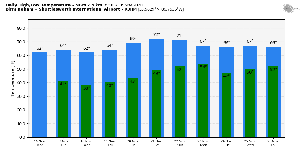
Today will feature sunshine in full supply with a high in the low to mid 60s. The average high for Birmingham on November 16 is 65. No change tomorrow; lots of sun with a high in the mid 60s. Then, a new surge of cool, dry air arrives tomorrow night.
Many places will see a freeze early Wednesday; we project lows between 25 and 35 degrees. Wednesday will be sunny with a high in the 57-62 degree range. And, dry weather continues Thursday and Friday with highs in the 60s. The weather will be nice and quiet this week.
THE ALABAMA WEEKEND: The weather will be a bit warmer over the weekend with highs in the low 70s. The sky will be mostly sunny Saturday, and partly sunny Sunday.
THANKSGIVING WEEK: A cold front could bring a few showers to Alabama Monday; then dry weather is expected Tuesday and Wednesday before another chance of showers Thanksgiving Day. Highs for the week will be mostly in the 60s… See the Weather Xtreme video for maps, graphics, and more details.
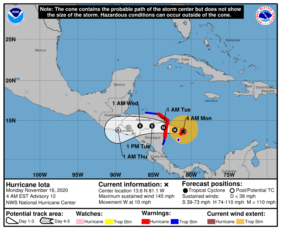
HURRICANE IOTA: Iota is packing sustained winds of 145 mph, and could be near category five strength with it moves into Central America tonight. Extreme winds and a life-threatening storm surge are expected along portions of the coast of northeastern Nicaragua and eastern Honduras, where a hurricane warning is in effect. Through Thursday, heavy rainfall from Iota will likely lead to life-threatening flash flooding and river flooding across portions of Central America. Flooding and mudslides in Honduras and Nicaragua could be exacerbated by Hurricane Etas recent effects there, resulting in significant to potentially catastrophic impacts.
The rest of the Atlantic basin is quiet.
ON THIS DATE IN 1989: Snow squalls were moving through North Alabama, the day following an F4 tornado that killed 21 people in Huntsville.
ON THIS DATE IN 2006: An early morning F3 tornado killed eight people, injured 20 others and left 100 people homeless in Riegelwood, North Carolina. This storm was the second deadliest tornado in the state in the past 50 years.
BEACH FORECAST: Click here to see the AlabamaWx Beach Forecast Center page.
WEATHER BRAINS: Don’t forget you can listen to our weekly 90 minute show anytime on your favorite podcast app. This is the show all about weather featuring many familiar voices, including our meteorologists here at ABC 33/40.
CONNECT: You can find me on all of the major social networks…
Look for the next Weather Xtreme video here by 4:00 this afternoon. Enjoy the day!
Category: Alabama's Weather, ALL POSTS, Weather Xtreme Videos
About the Author (Author Profile)
James Spann is one of the most recognized and trusted television meteorologists in the industry. He holds the AMS CCM designation and television seals from the AMS and NWA. He is a past winner of the Broadcast Meteorologist of the Year from both professional organizations.Subscribe
If you enjoyed this article, subscribe to receive more just like it.


