Windy, Cold, Snow Flurries/Showers Today
WINTER-LIKE DAY: Temperatures will go the wrong way across Alabama today following the system that brought soaking rains and wind to the state yesterday and last night. We are in the 40s at daybreak, but look for 30s by mid to late morning with an icy north wind. As a deep upper trough swings through, it will squeeze out snow flurries and showers in the cold air over the northern half of the state today and early tonight. The main window for snow will come from about 10:00 a.m. until 8:00 p.m.
A few moderate snow showers are possible over North Alabama, but for now we expect no significant impact or accumulation due to warm ground temperatures, the mostly light nature and short duration of the precipitation, surface temperatures above freezing, and strong northwest winds. There is a chance, however, of a “dusting” on grassy areas across higher terrain of Northeast Alabama where heavier snow showers develop.
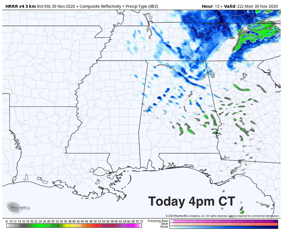
Temperatures this afternoon across North/Central Alabama will settle into the 33-38 degree range, and a northwest wind of 15-25 mph will make it feel colder. South Alabama will hold in the 40s all day.
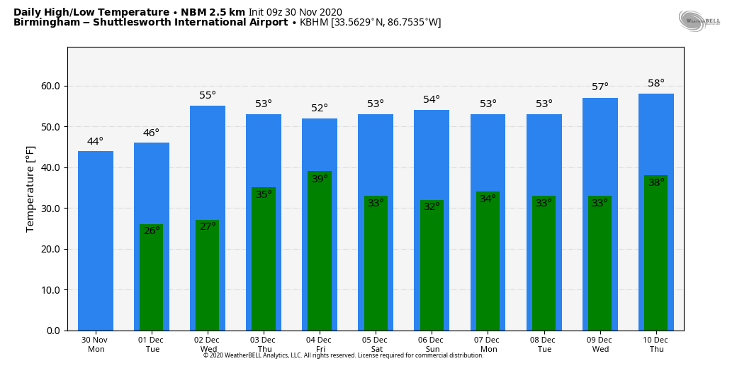
TONIGHT: The sky will clear late tonight, and by daybreak tomorrow we project lows in the 20-26 degree range over the northern half of the state, with a freeze all the way down to the Gulf Coast. Freeze warnings are in effect for South Alabama (there are no freeze warnings for the northern part of the state since they have already experienced a signifiant freeze earlier in the season).
REST OF THE WEEK: Tomorrow and Wednesday will be sunny with a warming trend. The high tomorrow will be in the upper 40s, followed by mid 50s Wednesday. Clouds move back in Wednesday night, and we will mention a chance of some light rain Thursday with a passing disturbance. Moisture return will be very limited, and rain amounts will be under a quarter of an inch. Temperatures will hold in the 40s most of the day.
The sky becomes partly sunny Friday; the high will be in the mid 50s.
THE ALABAMA WEEKEND: A dry mass means a sunny sky Saturday and Sunday; lows will be mostly in the 30s, highs in the 50s.
NEXT WEEK: The week looks fairly quiet with little, if any chance of rain based on model data we are seeing now. Temperatures will remain a bit below average with highs mostly in the 50s… See the Weather Xtreme video for maps, graphics, and more details.
HURRICANE SEASON ENDS TODAY: In total, the 2020 season produced 30 named storms (top winds of 39 mph or greater), of which 13 became hurricanes (top winds of 74 mph or greater), including six major hurricanes (top winds of 111 mph or greater). This is the most storms on record, surpassing the 28 from 2005, and the second-highest number of hurricanes on record.
We should note today NHC is watching a large non-tropical low pressure system that is centered just north of the Madeira Islands… it is continuing to produce disorganized showers and thunderstorms. This low is expected to meander over the next day or so and could acquire subtropical characteristics during that time. Afterwards, environmental conditions are forecast to become unfavorable for further development. Regardless of subtropical formation, this system will continue to produce strong winds and locally heavy rains in the Madeira Islands through Tuesday. The rest of the Atlantic basin is quiet.
ON THIS DATE IN 1925: A rare late November tropical storm began to affect the west coast of Florida as it strengthened during the day. The storm made landfall very early on December 1st south of Tampa Bay, weakened as it crossed central Florida, and exited around St. Augustine. Heavy rain continued over northeast Florida on the 2nd. Gale force winds were reported from the Keys to Jacksonville and over 50 people lost their lives, mostly on ships at sea. Damage along the coast south of Jacksonville was heavy and excessive rain and wind seriously damaged citrus and truck crops.
ON THIS DATE IN 2016: Just after midnight on November 30, 2016, an EF3 tornado crossed through parts of Jackson and DeKalb Counties in Northeast Alabama. This was one of 39 tornadoes, during a 2-day outbreak. There was significant damage in the towns of Rosalie and Ider. Sadly, four people were killed.
BEACH FORECAST: Click here to see the AlabamaWx Beach Forecast Center page.
WEATHER BRAINS: Don’t forget you can listen to our weekly 90 minute show anytime on your favorite podcast app. This is the show all about weather featuring many familiar voices, including our meteorologists here at ABC 33/40.
CONNECT: You can find me on all of the major social networks…
Look for the next Weather Xtreme video here by 4:00 this afternoon… enjoy the day!
Category: Alabama's Weather, ALL POSTS, Weather Xtreme Videos
About the Author (Author Profile)
James Spann is one of the most recognized and trusted television meteorologists in the industry. He holds the AMS CCM designation and television seals from the AMS and NWA. He is a past winner of the Broadcast Meteorologist of the Year from both professional organizations.Subscribe
If you enjoyed this article, subscribe to receive more just like it.


