Unseasonably Mild Through Thursday; Much Colder This Weekend
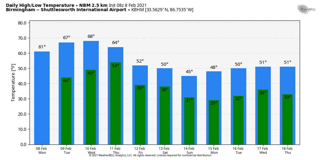
WARMING TREND AHEAD: After a sub-freezing start, look for a nice warm-up across Alabama today. With a partly to mostly sunny sky, we project a high around 60 degrees this afternoon. Then, tomorrow, the high will be in the 65-70 degree range with a mix of sun and clouds. Moisture levels rise Wednesday… the sky will be mostly cloudy with potential for a few scattered showers during the day. The weather will stay mild with a high in the upper 60s for most communities.
THURSDAY/FRIDAY: Rain will become widespread across Alabama Thursday ahead of an Arctic cold front. There will be some surface based instability, but the better shear values will be north of the front in the cold air, and for now severe storms are not expected. Rain amounts of around one inch are likely Wednesday night into Thursday. Then, Friday will be a generally dry day for the state with just a few lingering showers over the far southern counties. The weather will be cooler, but not excessively cold… highs will be in the 50s.
THE ALABAMA WEEKEND: Confidence is growing that much colder air will move into the state Saturday night, but there is still considerable model disagreement in the chance of any precipitation. For now, we believe Saturday will be a mostly cloudy day with potential for temperatures to reach 60 degrees. There will some chance of rain Saturday afternoon or Saturday night, followed by sharply colder air Sunday. Temperatures will likely reach the teens over the northern half of the state early Sunday morning, with 20s all the way down to the Gulf Coast. Sunday will be a dry but cold day with a high in the 30s for the Tennessee Valley, close to 40 for places like Tuscaloosa, Birmingham, and Anniston, and mid to upper 40s for South Alabama.
The biggest question involves Saturday night… involving a potential window for freezing rain and ice as the shallow layer of cold air rushes into the state. For now the reliable European global model says no, and we will side with that solution for now. But, just know the forecast could change as we get into the weekend. All global models have struggled with this pattern.
NEXT WEEK: The next wave in the active southern branch of the jet stream will likely bring rain to Alabama Tuesday, followed by cold and dry weather for the latter half of the week. See the Weather Xtreme video for maps, graphics, and more details.
We note the CPC (Climate Prediction Center) outlook for February 15-21 still shows below average temperatures for much of the U.S., including the Deep South.
ON THIS DATE IN 2013: A nor’easter produced heavy snowfall over the New England states. Total snowfall in Boston, Massachusetts, reached 24.9 inches, the fifth-highest total ever recorded in the city. New York City officially recorded 11.4 inches of snow at Central Park, and Portland, Maine, set a record of 31.9 inches.
BEACH FORECAST: Click here to see the AlabamaWx Beach Forecast Center page.
WEATHER BRAINS: Don’t forget you can listen to our weekly 90 minute show anytime on your favorite podcast app. This is the show all about weather featuring many familiar voices, including our meteorologists here at ABC 33/40.
CONNECT: You can find me on all of the major social networks…
Look for the next Weather Xtreme video here by 3:00 this afternoon… enjoy the day!
Category: Alabama's Weather, ALL POSTS, Weather Xtreme Videos
About the Author (Author Profile)
James Spann is one of the most recognized and trusted television meteorologists in the industry. He holds the AMS CCM designation and television seals from the AMS and NWA. He is a past winner of the Broadcast Meteorologist of the Year from both professional organizations.Subscribe
If you enjoyed this article, subscribe to receive more just like it.


