Dangerous Severe Weather Setup This Afternoon And Tonight
VOLATILE SITUATION: We have a dangerous severe weather setup for Alabama later today, tonight, and early tomorrow morning. A deep, negative tilt upper trough with strong wind fields west of the state will provide dynamic support for widespread severe thunderstorms this afternoon and tonight.
We note there is a “wedge front” over Northeast Alabama this morning; north and east of that front the air is cool and relatively stable, but warm, moist, unstable air will surge northward late today and tonight replacing that cooler air.
SPC has a issued a “high risk” (level 5/5) for parts of Central and West Alabama (including Birmingham and Tuscaloosa), most of the rest of the state is in a “moderate risk” (level 4/5). Please don’t get too hung up in risk categories or map colors… just understand the entire state has a significant risk of severe storms.
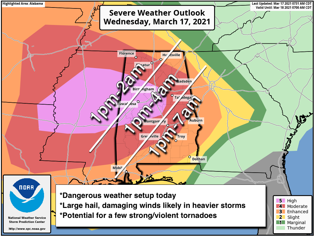
TIMING: We have showers and thunderstorms in progress this morning in scattered pockets across the state, and those will be strong with potential for small hail and gusty winds. But, the core severe weather opens up around 1:00 this afternoon statewide, and will continue through the late night and pre-dawn hours. Storms will end from west to east after midnight tonight… a few storms could linger across Southeast Alabama until 8:00 a.m. tomorrow.
THREATS: Widespread severe storms capable of producing tornadoes (several of which may be intense), very large hail and intense damaging wind gusts are expected. A few violent, long track tornadoes are possible.
RAIN: Additional rain amounts of 1-2 inches are likely, and some isolated flooding issues are possible.
GET READY NOW: Here are some important points about preparedness…
*Have at least two ways of hearing warnings. Every Alabama home and business needs a NOAA Weather Radio; the model most used is the Midland WR-120, available at most local “big box” retailers. Weather radio receivers do not rely on cellular networks and are very reliable. The second way is your phone; be sure WEA (Wireless Emergency Alerts) are enabled, and have a reliable app like the ABC 33/40 Weather app, which also pushes warnings. NEVER rely on an outdoor siren. NEVER.
*Know your safe place. In a site built home, it is a small room, on the lowest floor, near the center of the house, away from windows. And, in that safe place, have helmets for everyone (this means adults too!). We also recommend a portable airhorn for everyone (to alert first responders if you need help), and hard soled shoes in case you have to walk over a tornado debris field.
*You can’t stay in a mobile home during a tornado warning. Know where you are going, and how to get there quickly. If there is no community shelter nearby, go to a business like a gas station, convenience store, or restaurant that is open 24/7.
*Be sure you can find your home on a map. Identify the county you are in, and the ones surrounding you. Map skill is very important on severe weather days!
Please help us by spreading the word about this serious threat. Many folks don’t pay close attention to the weather… tell your relatives, friends, and neighbors and help us get them ready. We don’t share this to scare anyone… we simply have a responsibility to let you know the danger.
For those with a weather phobia, or high anxiety, understand even on a big severe weather day odds of any one home being hit by a tornado are still very low. Just be sure you can hear warnings, have a good plan, and we will get through the day together.
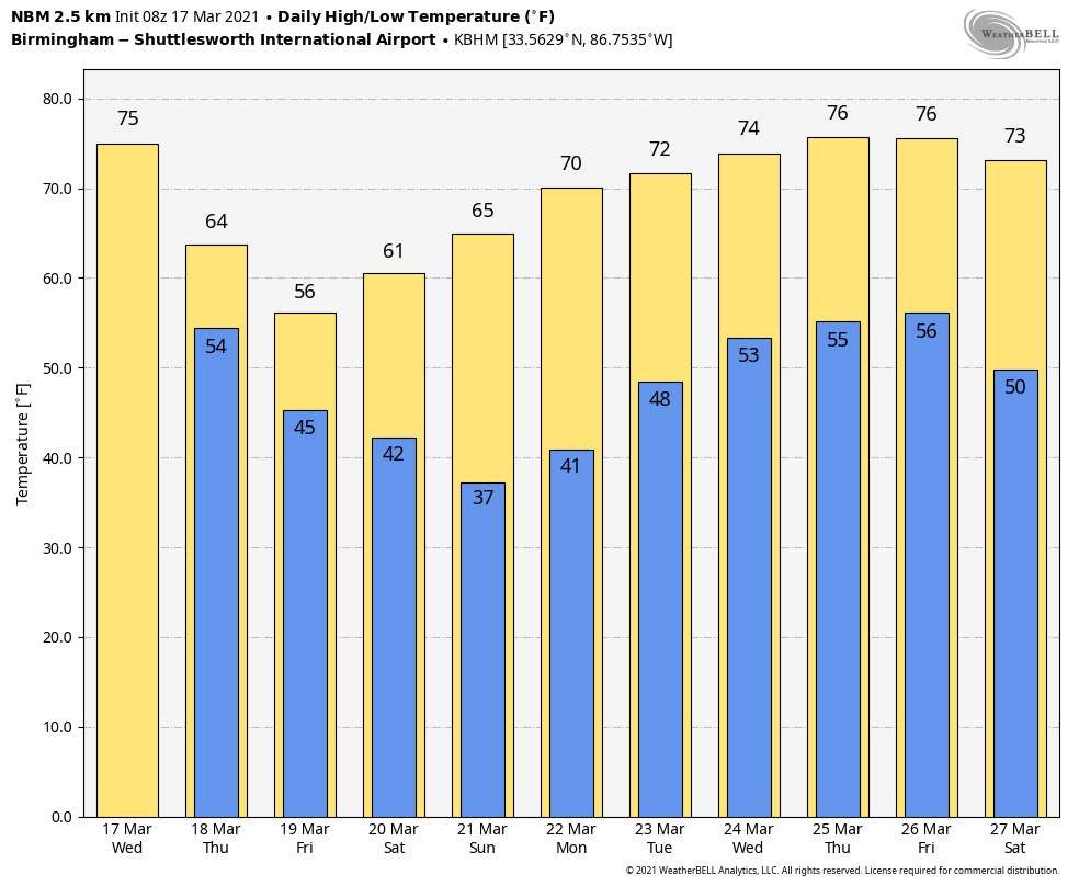
TOMORROW THROUGH THE WEEKEND: While tomorrow will be generally dry, clouds will linger much of the day. Temperatures will be noticeably lower with a high in the low 60s. Friday will be mostly cloudy, but again mostly dry, with a high in the 55-60 degree range. Then, the weekend will be rain-free with a good supply of sunshine Saturday and Sunday. The high Saturday will be in the low 60s, followed by mid 60s Sunday. Sunday morning will be cold with a low in the 30s… frost is likely, and colder pockets could see a light freeze.
NEXT WEEK: The next round of showers and storms will come late Tuesday and Tuesday night… for now the severe weather threat looks low with this system. Another round of storms is likely late in the week on Friday; too early to know if that one will bring severe thunderstorms to the state. See the Weather Xtreme video for maps, graphics, and more details.
ON THIS DATE IN 1990: Showers and thunderstorms associated with a slow-moving cold front produced torrential rains across parts of the southeastern U.S. over two days. Flooding claimed the lives of at least 22 persons, including thirteen in Alabama. Up to 16 inches of rain deluged southern Alabama with 10.63 inches reported at Mobile in 24 hours. The town of Elba was flooded with 6 to 12 feet of water causing more than 25 million dollars damage, and total flood damage across Alabama exceeded 100 million dollars. Twenty-six counties in the state were declared disaster areas.
BEACH FORECAST: Click here to see the AlabamaWx Beach Forecast Center page.
WEATHER BRAINS: Don’t forget you can listen to our weekly 90 minute show anytime on your favorite podcast app. This is the show all about weather featuring many familiar voices, including our meteorologists here at ABC 33/40.
CONNECT: You can find me on all of the major social networks…
Join us on ABC 33/40 for severe weather coverage this afternoon and tonight… and STAY SAFE today!
Category: Alabama's Weather, ALL POSTS, Weather Xtreme Videos
About the Author (Author Profile)
James Spann is one of the most recognized and trusted television meteorologists in the industry. He holds the AMS CCM designation and television seals from the AMS and NWA. He is a past winner of the Broadcast Meteorologist of the Year from both professional organizations.Subscribe
If you enjoyed this article, subscribe to receive more just like it.


