Dangerous Severe Weather Setup Today
BE VERY WEATHER AWARE TODAY: A tornado outbreak is expected today into early this evening across parts of the Southeast U.S… including the northern half of Alabama. Several long-track strong tornadoes, destructive winds and very large hail are forecast, and everyone needs to pay close attention to watches and warnings that are issued.
A dynamic weather system with strong wind fields at the surface and aloft will interact with a very unstable, volatile airmass to bring the severe weather threat. SPC has a “high risk” (level 5/5) up for Northwest Alabama, with a “moderate risk” (level 4/5) down to Sand Rock, Glencoe, Calera, Marion, and Linden. The “enhanced risk” (level 3/5) extends as far south as Alexander City, Prattville, and Grove Hill.
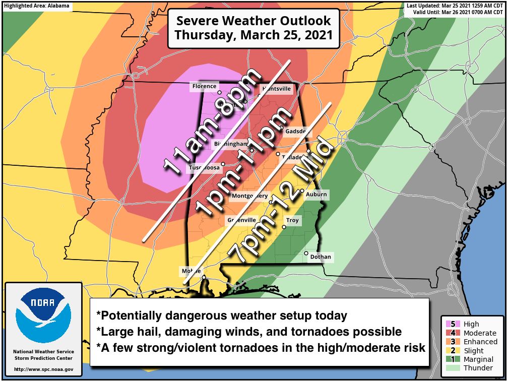
TIMING: A few isolated severe storms are possible this morning with hail and strong winds. An isolated tornado can’t be ruled out. But the main window for severe storms will open up in the “high risk” area across Northwest Alabama around 11:00 a.m. For most of North/Central Alabama… the threat comes from 1:00 p.m. until 11:00 p.m. Storms could linger over parts of East and South Alabama until midnight as they weaken.
THREATS: Storms will be capable of producing large hail, damaging winds, and tornadoes. A few strong/violent, long track tornadoes are possible in the high/moderate risk areas.
GRADIENT WIND: Away from thunderstorms, a wind advisory is in effect for much of the state. South winds will gust as high as 30 mph today due to a tight pressure gradient.
RAIN: Rain amounts could exceed two inches today over the Tennessee Valley of North Alabama, where a flash flood watch is in effect. For the rest of North/Central Alabama totals of 1-2 inches are likely through midnight.
BE READY: Alabamians did a remarkable job of being ready for last week’s severe weather event on March 17. We had 25 tornadoes in the state, but not a single injury despite major damage. We need the same level of preparedness today.
*Have TWO ways of hearing warnings. Never, ever, ever rely on a siren. Every Alabama home and business needs a NOAA Weather Radio (the most popular model is the Midland WR-120, which is sold in most local big box retailers). The other way is your phone… be sure emergency alerts are enabled (look under settings, and notifications), and install the free ABC 33/40 Weather app.
*Know the safe place in your house, and in that safe place have helmets for everyone. Bicycle helmets and batting helmets work well. We also recommend portable air horns and hard soled shoes for everyone.
*If you live in an apartment complex, you can’t be above the first level. Shelter with a friend on the ground level, or ask management if they can open the clubhouse during a tornado warning.
*If you live in a mobile home, you can’t stay there during a tornado warning. Know the location of the nearest shelter, or business that is open 24/7. Know how to get there quickly.
BE A HERO: You can help us. Tell your friends, neighbors, and relatives about the threat, and what they need to do to get ready. And, if they fall in a tornado warning polygon today or tonight, call them or text them to let them know about the threat. You are our most valuable resource in spreading the word!
Many of you have anxiety about severe weather, especially those that have gone through tornadoes or other kinds of violent weather. Have comfort knowing that even on the biggest severe weather days, odds of any one home being hit by a tornado are very low. But, you have to pay attention and be prepared. We will get through this day together.
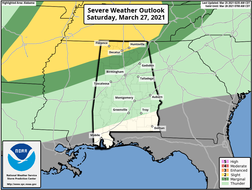
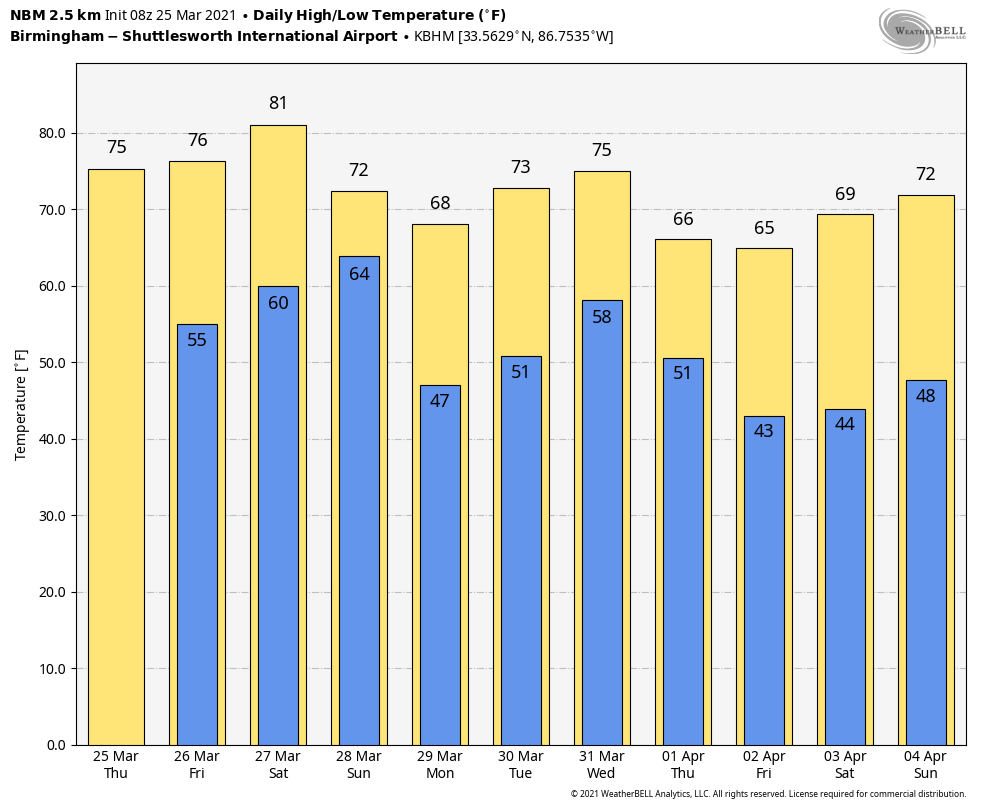
TOMORROW AND THE WEEKEND: Tomorrow will be dry with a partly to mostly sunny sky; the high will be in the upper 70s. A warm front will bring showers and a few thunderstorms to the state Saturday; SPC has a “slight risk” (level 2/5) defined for parts of the Tennessee Valley, where a few storms could produce hail and strong gusty winds during the afternoon and evening hours. For now we are not expecting a tornado threat.
Showers are likely Sunday as the front moves southward again as a cold front. The high Saturday will be in the low 80s, followed by mid 70s Sunday.
NEXT WEEK: Showers are possible over South Alabama Monday… then we will have a chance of some rain statewide Wednesday afternoon and Wednesday night, followed by cooler, drier air Thursday and Friday. See the Weather Xtreme video for maps, graphics, and more details.
ON THIS DATE IN 1901: More than 20 people were killed by an estimated F3 tornado that moved across parts of Birmingham. The twister cut a 15-mile path from the south side of the city to Avondale to Irondale.
BEACH FORECAST: Click here to see the AlabamaWx Beach Forecast Center page.
WEATHER BRAINS: Don’t forget you can listen to our weekly 90 minute show anytime on your favorite podcast app. This is the show all about weather featuring many familiar voices, including our meteorologists here at ABC 33/40.
CONNECT: You can find me on all of the major social networks…
Stay tuned to ABC 33/40 for live coverage of the severe weather outbreak later today!!
Category: Alabama's Weather, ALL POSTS, Weather Xtreme Videos
About the Author (Author Profile)
James Spann is one of the most recognized and trusted television meteorologists in the industry. He holds the AMS CCM designation and television seals from the AMS and NWA. He is a past winner of the Broadcast Meteorologist of the Year from both professional organizations.Subscribe
If you enjoyed this article, subscribe to receive more just like it.


