Beautiful Spring Day Today; Storms Return Wednesday
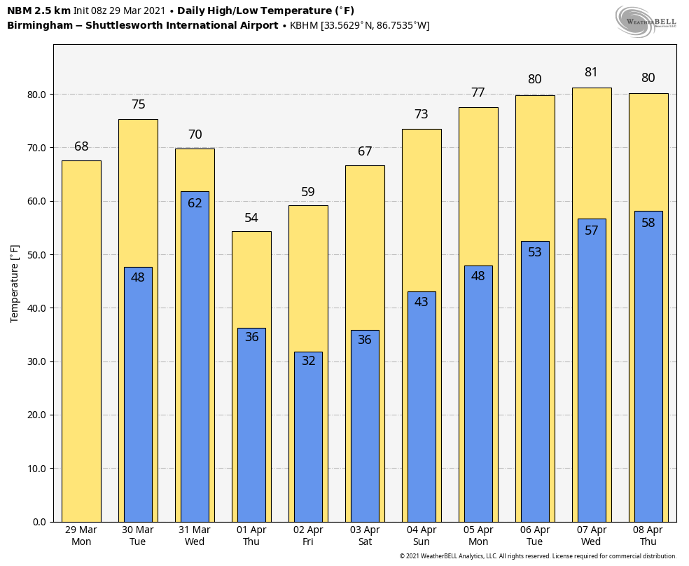
CLEAR SAILING: Today will be a beautiful spring day for Alabama with sunshine in full supply. After a cool start, we expect a high around 70 degrees today. Clouds will increase tomorrow ahead of an approaching cold front, and showers are possible over the southern half of the state by afternoon. That front will bring a band of showers and thunderstorms into the state Wednesday.
SPC has defined a “marginal risk” (level 1/5) of severe thunderstorms for most of Alabama Wednesday.
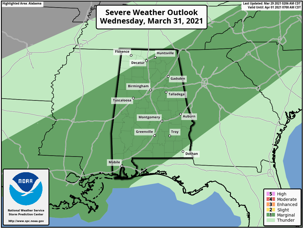
Thunderstorms will be capable of producing small hail, strong winds, and a brief, isolated tornado or two. While this is not a high end threat like last Thursday, everyone still needs to be weather aware Wednesday and be in a position to hear warnings if they are needed. The sky will clear Wednesday night as colder, drier air arrives.
Thursday will be a sunny, but very cool day for Alabama. The high will be in the 52-57 degree range over the northern half of the state with a brisk northwest wind.
LATE SEASON FREEZE AHEAD: Temperatures will drop below freezing Friday morning over the northern and central counties of Alabama. We project a low in the 27-32 degree range for most places. For colder pockets, temperatures could be below freezing for over 6 hours late Thursday night and early Friday morning. This is not unusual for early April… in fact, long time readers know my advice every year. Don’t plant anything that will be harmed by a freeze until April 15.
The day Friday will be sunny with a high around 60. For the weekend, sunny weather continues Saturday and Sunday with a warming trend. The high Saturday will be in the mid 60s, followed by low 70s Sunday.
NEXT WEEK: The weather looks quiet at least for the first half of the week with a warming trend; we reach the low 80s by mid-week. Showers or storms will most likely return by Thursday or Friday… See the Weather Xtreme video for maps, graphics, and more details.
THURSDAY’S TORNADOES: NWS Birmingham has identified ten tornadoes from last Thursday’s severe weather event, including an EF-3 that was down for 50.36 miles from near West Blocton in Bibb County to Camp Winnataska in St. Clair County. This is the one that produced extensive damage in places like Helena, Pelham, Eagle Point, and Shoal Creek. The Ohatchee-Wellington tornado in Calhoun County was rated EF-2; it was on the ground for 24 miles and was responsible for five fatalities.
ON THIS DATE IN 1942: A slow-moving low-pressure system brought 11.5 inches of snow to the nation’s capital on March 29, 1942. It still stands as the highest March snowfall on record in Washington, D.C. on a single calendar day. Also, Baltimore, Maryland recorded an imposing total of 21.9 inches of snow on the same day. On the flip side, eight days later, the temperature in D.C. soared to 92 degrees on April 6, 1942, and it remains the highest temperature on record for April 6.
BEACH FORECAST: Click here to see the AlabamaWx Beach Forecast Center page.
WEATHER BRAINS: Don’t forget you can listen to our weekly 90 minute show anytime on your favorite podcast app. This is the show all about weather featuring many familiar voices, including our meteorologists here at ABC 33/40.
CONNECT: You can find me on all of the major social networks…
Look for the next Weather Xtreme video here by 3:00 this afternoon… enjoy the day!
Category: Alabama's Weather, ALL POSTS, Weather Xtreme Videos
About the Author (Author Profile)
James Spann is one of the most recognized and trusted television meteorologists in the industry. He holds the AMS CCM designation and television seals from the AMS and NWA. He is a past winner of the Broadcast Meteorologist of the Year from both professional organizations.Subscribe
If you enjoyed this article, subscribe to receive more just like it.


