Strong/Severe Storms Move Into Alabama Late Tonight
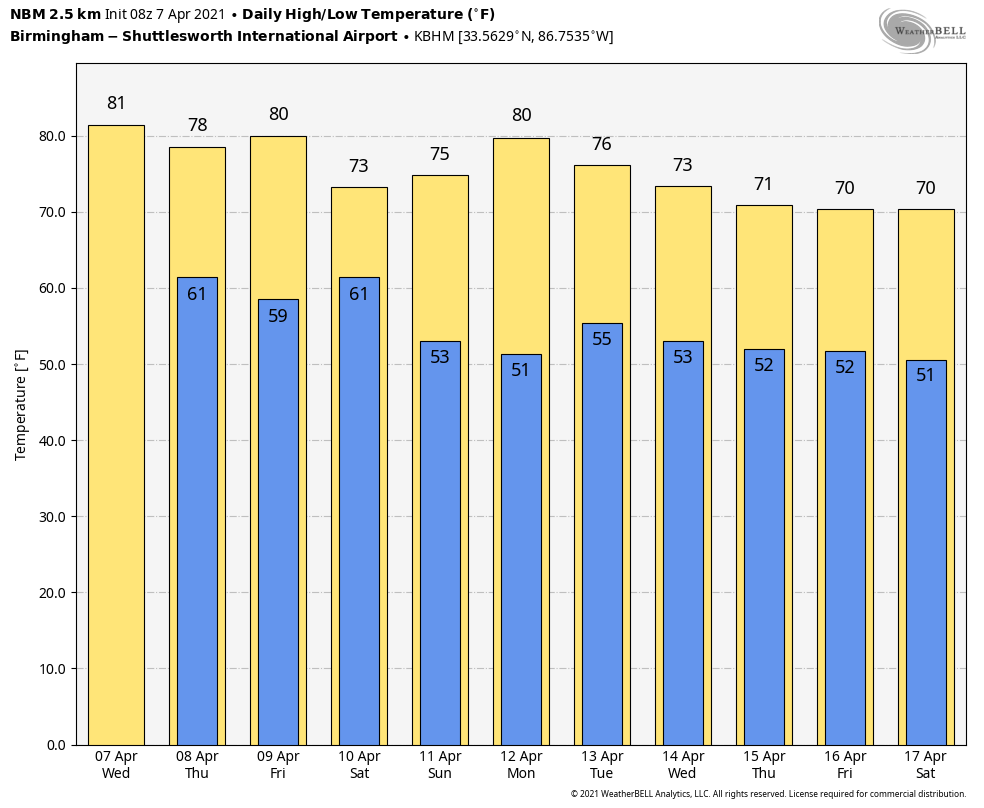
MOSTLY DRY DURING THE DAY: We are forecasting a partly sunny sky across Alabama today with a high between 78 and 82 degrees for most communities. A few isolated showers could pop up this afternoon as moisture levels rise, but most places will be dry. A band of showers and thunderstorms will push into Alabama late tonight, and SPC continues to define a “slight risk” (level 2/5) of severe thunderstorms for a few counties near the Mississippi state line, with a “marginal risk” (level 1/5) as far east as Huntsville, Columbiana, Verbena, and Mobile.
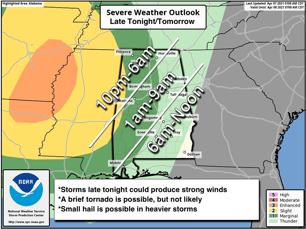
Storms will enter far Northwest Alabama sometime between 10:00 p.m. and midnight… they will move slowly southeast after midnight into the early morning hours tomorrow. Storms will be capable of producing strong, gusty winds and small hail. A brief, isolated tornado is possible, but not likely. While the severe weather threat late tonight and tomorrow morning isn’t “major”, you still need to pay attention to warnings if they are needed. Winds could be strong enough to bring down a few trees, and again a brief tornado can’t be ruled out. This is early April in Alabama.
The storms will end by mid-morning tomorrow as a slot of drier air works into the state, and the sky becomes partly sunny tomorrow afternoon with temperatures rising into the low to mid 80s. For some places, tomorrow will be the warmest day so far this year.
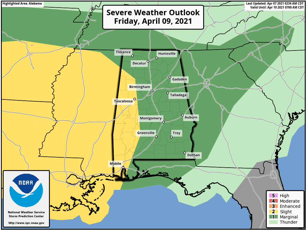
FRIDAY AND THE WEEKEND: Additional showers and storms will likely form across Alabama late tomorrow night into Friday. This won’t be a continuous rain, and you might even see a few intervals of sunshine Friday. But, where storms do form they could be strong, especially Friday afternoon when the air becomes very unstable. SPC has defined a “slight risk” (level 2/5) of severe thunderstorms Friday west of a line from Hamilton to Tuscaloosa to Camden to Fairhope, with a “marginal risk” (level 1/5) for the rest of the state. The main threats Friday will come from hail and strong winds.
Unsettled weather continues Friday night into Saturday. There is evidence an organized thunderstorm complex will move into the state Saturday morning with potential for strong winds and a few isolated tornadoes, but in this complex pattern it is difficult to define the magnitude of the threat now. Models are hinting the main chance of rain and storms will shift into South Alabama by Saturday afternoon as drier air begins to filter into the northern half of the state. Then, Sunday looks mostly rain-free statewide with a partly to mostly sunny sky. Highs will be in the mid to upper 70s Friday through Sunday.
Rain amounts between tonight and Saturday will be in the 2-3 inch rain for most of the state… for now no major flooding issues are expected.
NEXT WEEK: At the moment the week looks relatively quiet; a front could bring a few showers Tuesday, but it doesn’t look like a major rain event. See the Weather Xtreme video for maps, graphics, and more details.
ON THIS DATE IN 1980: Severe thunderstorms spawned tornadoes that ripped through central Arkansas. The severe thunderstorms also produce high winds and baseball size hail. Five counties were declared disaster areas by President Carter. A tornado causing F3 damage also affected St. Louis and St. Charles counties in Missouri producing $2.5 million in damage.
ON THIS DATE IN 2006: Severe thunderstorms moved through Alabama producing over twenty tornadoes, all EF-0/EF-1. EF-1 tornadoes touched down near Gardendale and Roebuck in Jefferson County.
BEACH FORECAST: Click here to see the AlabamaWx Beach Forecast Center page.
WEATHER BRAINS: Don’t forget you can listen to our weekly 90 minute show anytime on your favorite podcast app. This is the show all about weather featuring many familiar voices, including our meteorologists here at ABC 33/40.
CONNECT: You can find me on all of the major social networks…
Look for the next Weather Xtreme video here by 3:00 this afternoon… enjoy the day!
Category: Alabama's Weather, ALL POSTS, Weather Xtreme Videos
About the Author (Author Profile)
James Spann is one of the most recognized and trusted television meteorologists in the industry. He holds the AMS CCM designation and television seals from the AMS and NWA. He is a past winner of the Broadcast Meteorologist of the Year from both professional organizations.Subscribe
If you enjoyed this article, subscribe to receive more just like it.


