

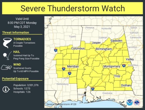
Storm Threat Increasing; Severe Thunderstorm Watch in effect until 8PM
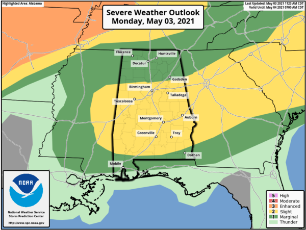
STORMY START TO WEEK: Showers and strong thunderstorms have been ongoing since early this morning, and these will continue through the rest of today. The SPC has expanded the “slight risk” (level 2/5) of severe storms for most of Alabama today, with a “marginal risk” for much of the rest of the state.
There is a warm and muggy air mass in place across the state as temperatures are surging into the 80s this afternoon. Storms will continue to expand in coverage the rest of today with the main threat with the heavier thunderstorms today being hail and strong, gusty winds. The tornado threat is low, but not zero. The Tornado Watch that was in effect for East Central Alabama until 3PM, has been replaced with a Severe Thunderstorm Watch in effect until 8PM for much of Alabama.
Remain weather aware the rest of today. Storms should wind down later tonight with only lingering showers overnight.
TOMORROW: A more significant severe weather threat is expected tomorrow as much of the state is in an “enhanced risk” (level 3/5), which extends as far south as Jackson, Greenville, and Auburn.
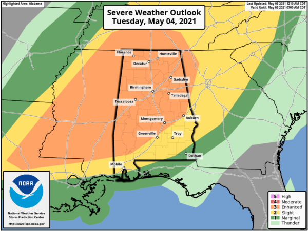
The air will become very unstable tomorrow afternoon across Alabama, and with an approaching upper trough storms should begin to develop across the state tomorrow, while a MCS (cluster of storms) moves across Mississippi and move into Alabama by mid-afternoon and continuing to move across the state tomorrow night. These storms will be capable of producing large hail, damaging winds, and a few tornadoes. The main window for severe thunderstorms tomorrow will come from roughly 1PM-11PM.
Along with the storm, threat, rain amounts between now and late tomorrow night will be in the 2-4 inch range for much of the state, with some isolated higher amounts. We will have to monitor trends as some areas of flash flooding could develop.
BEACH FORECAST CENTER: Get the latest weather and rip current forecasts for the beaches from Fort Morgan to Panama City on our Beach Forecast Center page. There, you can select the forecast of the region that you are interested in visiting.
WORLD TEMPERATURE EXTREMES: Over the last 24 hours, the highest observation outside the U.S. was 113.0F at Birni-N’Konni, Niger. The lowest observation was -101.2F at Vostok, Antarctica.
CONTIGUOUS TEMPERATURE EXTREMES: Over the last 24 hours, the highest observation was 107F at Zapata, TX. The lowest observation was 17F at Bridgeport, CA.
WEATHER ON THIS DATE IN 1990: A stubborn late season storm slowly crawled across southern Colorado the first three days of the month producing heavy snow from the San Juan Mountains to the southeast plains. The storm produced up to three feet of snow in the higher elevations of southern Colorado, and 18 to 22 inches of snow along the eastern slopes of the Central Mountains of New Mexico. Pueblo CO reported a record 10.6 inches of snow for the month as a result of the storm, and a record total for the winter season of 69.6 inches.
Category: Alabama's Weather, ALL POSTS, Severe Weather
About the Author (Author Profile)
Macon, Georgia Television Chief Meteorologist, Birmingham native, and long time Contributor on AlabamaWX. Stormchaser. I did not choose Weather, it chose Me. College Football Fanatic. @Ryan_StinnetSubscribe
If you enjoyed this article, subscribe to receive more just like it.


