Rain Ends Later This Morning; Then Mostly Dry
RADAR CHECK: Rain is widespread early this morning over East and South Alabama, with heavier thunderstorms moving along the Gulf Coast. Rain will end later this morning, and the rest of the day looks mostly dry with only isolated showers through tonight. Clouds will linger through the day, and temperatures over the northern half of the state will be about 15 to 20 degrees below average for mid-May with highs only in the low to mid 60s.
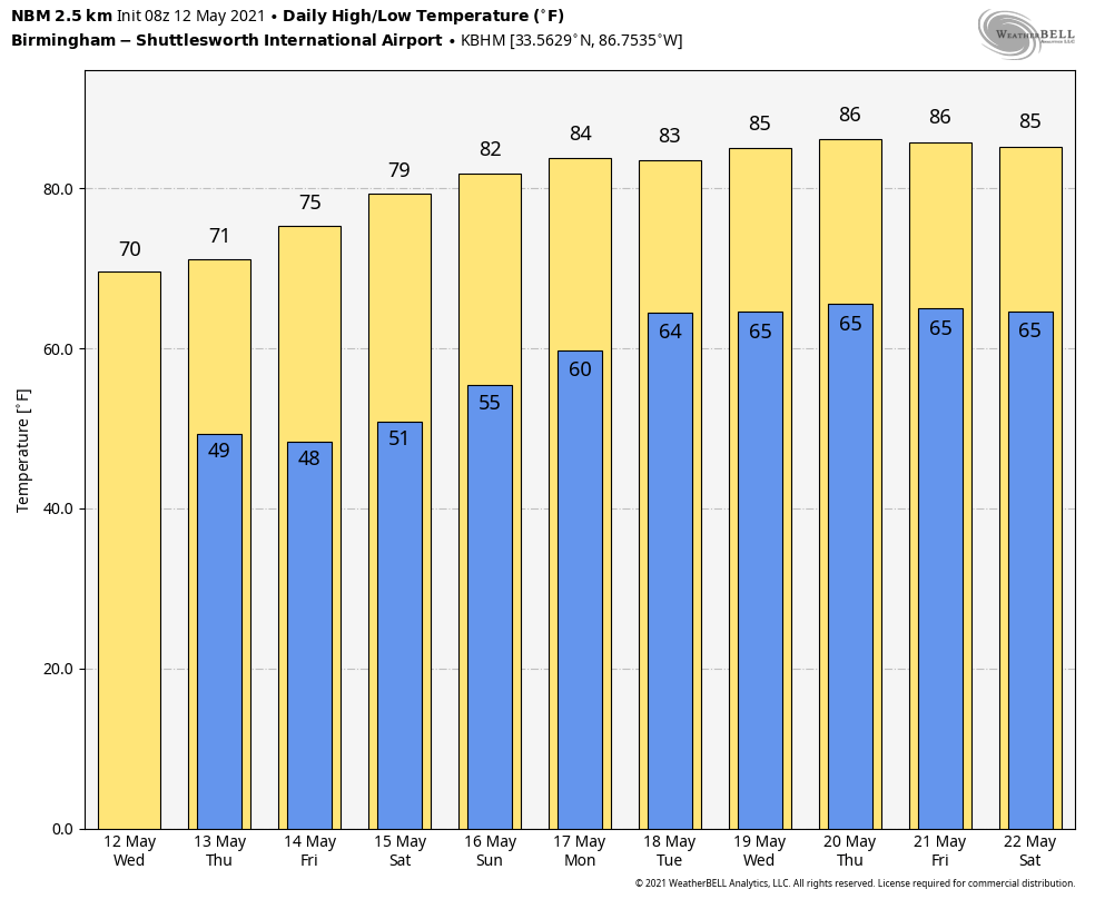
TOMORROW THROUGH THE WEEKEND: Look for clearing sky tomorrow as dry air returns to the state, and we will be rain-free through the weekend with a warming trend. Look for sunny days, and fair nights Friday through the weekend. The high tomorrow will be close to 70, followed by mid 70s Friday, 80 degree warmth Saturday, and low 80s Sunday.
NEXT WEEK: Moist air returns to the state Monday, when a few isolated showers are possible, but the best chance of showers will remain a little west of Alabama. Then, for the rest of the week, the weather will be warm and humid with some risk of scattered showers and thunderstorms on a daily basis. Highs will be mostly in the mid 80s… See the Weather Xtreme video for maps, graphics, and more details.
HURRICANE ZETA UPGRADED: The National Hurricane Center upgraded Hurricane Zeta to a Category 3 storm in its post-season report released yesterday. Zeta made landfall on October 28 near Cocodrie, Louisiana. According to the NHC, Zeta weakened to a tropical storm before rapidly intensifying to a Category 3 storm just before hitting land. It’s the strongest storm to make landfall in the U.S. so late in the year.
ON THIS DATE IN 1959: An F3 tornado touched down just south of Bessemer and moved northward into Fairfield. The most intense damage occurred near the beginning where 3 houses were demolished. Twenty houses and numerous other buildings were also damaged. Many trees and power lines were blown down along the damage path.
ON THIS DATE IN 1997: A towering F1 tornado ripped its way through the middle of Miami, Biscayne Bay, and Miami Beach right after lunch Monday, smashing cars and windows, tossing trees skyward and scaring the dickens out of thousands of people.
BEACH FORECAST: Click here to see the AlabamaWx Beach Forecast Center page.
WEATHER BRAINS: Don’t forget you can listen to our weekly 90 minute show anytime on your favorite podcast app. This is the show all about weather featuring many familiar voices, including our meteorologists here at ABC 33/40.
CONNECT: You can find me on all of the major social networks…
Look for the next Weather Xtreme video here by 3:00 this afternoon… enjoy the day!
Category: Alabama's Weather, ALL POSTS, Weather Xtreme Videos
About the Author (Author Profile)
James Spann is one of the most recognized and trusted television meteorologists in the industry. He holds the AMS CCM designation and television seals from the AMS and NWA. He is a past winner of the Broadcast Meteorologist of the Year from both professional organizations.Subscribe
If you enjoyed this article, subscribe to receive more just like it.


