A Few Strong Storms Later Today; Dry/Cooler Weekend Ahead
RADAR CHECK: We have a few isolated showers over Northwest Alabama early this morning, with a larger area of rain over West Tennessee and North Mississippi. We expect a general increase in the number of showers and thunderstorms across Alabama later today and tonight ahead an an approaching cold front. SPC maintains a “marginal risk” (level 1/5) for much of North and Central Alabama; the main threat with the heavier storms will come from gusty winds and small hail.
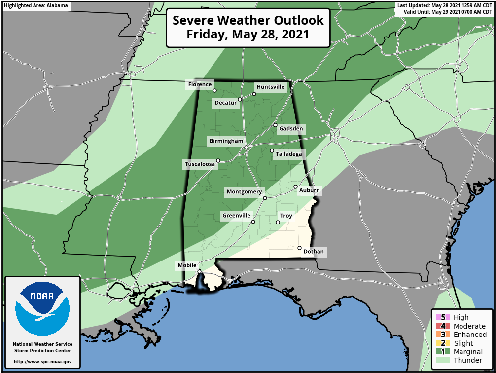
While showers remain possible over Northwest Alabama this morning, most of the showers and storms will come from about 11:00 a.m. until 7:00 p.m. for the northern half of the state… the activity mostly shifts down into South Alabama after 7:00 p.m. Rain distribution won’t be very even, but a few spots could see over 1/2 inch of rain where stronger thunderstorms develop. Expect a high today in the low 80s with more clouds than sun.
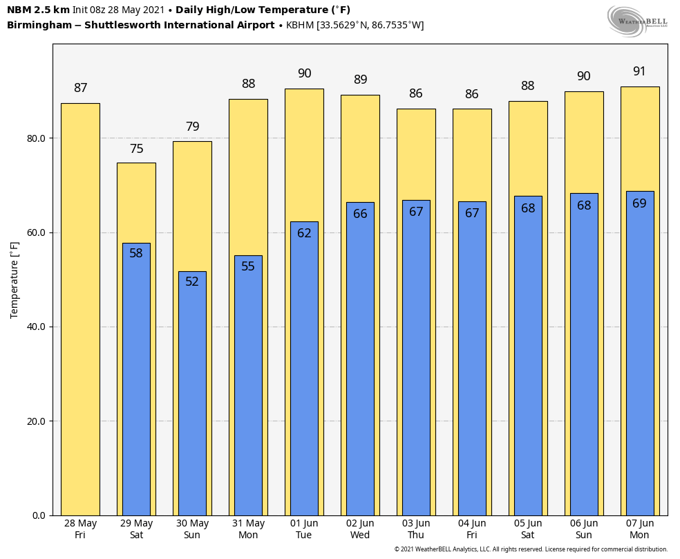
MEMORIAL DAY WEEKEND: A cooler, dry airmass will roll into Alabama late tonight, setting the stage for a very nice holiday weekend. Mostly sunny, pleasant days, and clear cool nights tomorrow through Monday. Highs drop into the 70s tomorrow and Sunday, with mid 80s by Monday. The coolest morning will come early Sunday, when colder pockets will drop into the 40s over the northern half of the state. Probably the last time that happens until sometime in late September or October.
REST OF NEXT WEEK: Moisture begins to return Tuesday, and we will mention a chance of isolated showers… then we are forecasting scattered to numerous showers and thunderstorms Wednesday through Friday as an upper trough sets up west of Alabama. Highs through the week will be in the 80s… See the Weather Xtreme video for maps, graphics, and more details.
TROPICS: All remains quiet across the Atlantic basin, and tropical storm formation is not expected through early next week. The “official” beginning of the Atlantic basin season is Tuesday.
SEC BASEBALL TOURNAMENT: A passing shower or storm is likely at the Hoover Met later today, but the weather will be dry and pleasant tonight through the weekend. Expect lots of sunshine tomorrow and Sunday with highs in the 70s along with lower humidity levels.
ON THIS DATE IN 1973: An F3 tornado moved east and struck the northern portion of Athens, Georgia. Destruction was massive near Athens, with losses estimated at ten million dollars. Damage from the storm included 545 homes and 17 businesses. Hundreds of large trees more than 100 years old were destroyed.
BEACH FORECAST: Click here to see the AlabamaWx Beach Forecast Center page.
WEATHER BRAINS: Don’t forget you can listen to our weekly 90 minute show anytime on your favorite podcast app. This is the show all about weather featuring many familiar voices, including our meteorologists here at ABC 33/40.
CONNECT: You can find me on all of the major social networks…
Look for the next Weather Xtreme video here by 4:00 this afternoon… enjoy the day!
Category: Alabama's Weather, ALL POSTS, Weather Xtreme Videos
About the Author (Author Profile)
James Spann is one of the most recognized and trusted television meteorologists in the industry. He holds the AMS CCM designation and television seals from the AMS and NWA. He is a past winner of the Broadcast Meteorologist of the Year from both professional organizations.Subscribe
If you enjoyed this article, subscribe to receive more just like it.


