Dry For Most Of The State Through Friday; Tropical Rain For The Weekend
REFRESHING MORNING: A dry airmass is allowing temperatures to fall into the 50s in many areas this morning. Some of the cooler spots at sunrise…
Black Creek 55
Cullman 56
Fort Payne 56
Haleyville 57
Pell City 57
Gadsden 58
Hueytown 58
Cottondale 58
Weaver 58
Scottsboro 59
Vance 59
Sylacauga 59
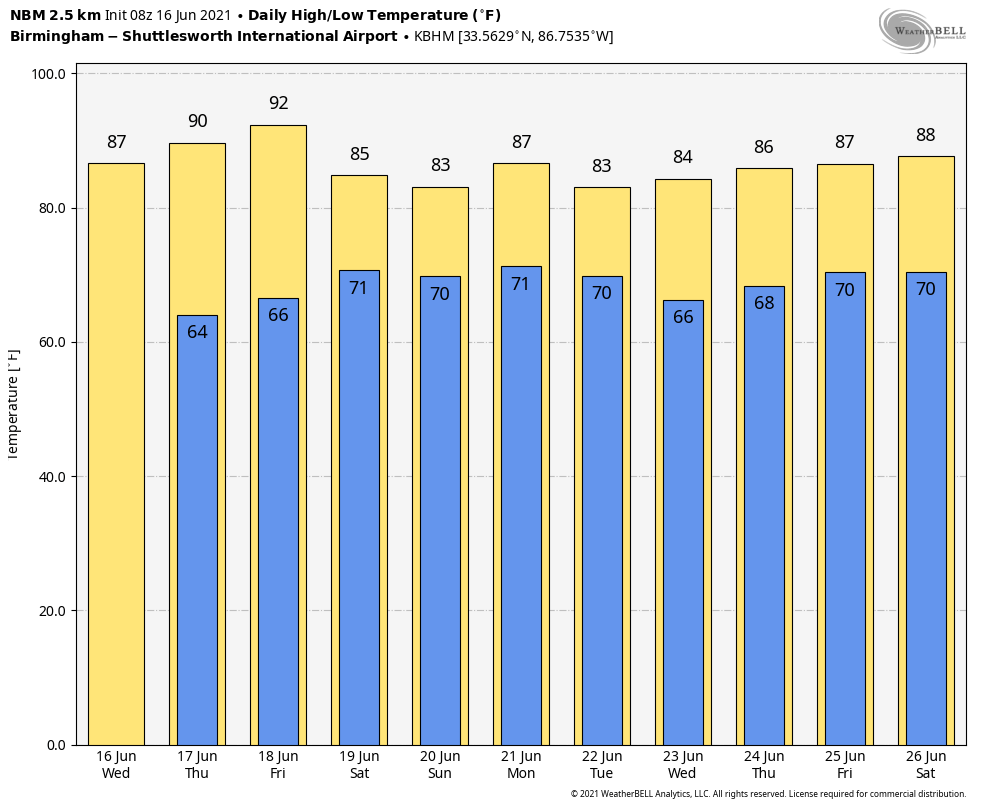
Today will be another sunny day with a high the mid to upper 80s, and the humidity levels will remain low for mid-June. Dry weather continues tomorrow, but some rain could move into extreme South Alabama Friday as a tropical low in the Gulf of Mexico approaches the coast. The northern 2/3 of the state will remain rain-free Friday with afternoon highs around 90 degrees.
THE ALABAMA WEEKEND: Rain will spread into the state Saturday. It is just too early to forecast the exact the rain begins for any given point since tropical system still doesn’t have a well defined low level center. Once that happens, and we get dropsonde data from reconnaissance aircraft, we will have better clarity on the timing. Rain should be fairly widespread across the entire state Saturday night and Sunday, and the rain could be heavy at times. We will also have to watch for embedded thunderstorms Sunday that try and rotate; sometimes tropical lows like this can produce a few brief, isolated tornadoes. Highs Saturday and Sunday will be in the 78-82 degree range.
NEXT WEEK: The chance of rain will remain high Monday, but we trend drier Tuesday and over the latter half of the week. See the Weather Xtreme video for maps, graphics, and more details.
TROPICS: Bill has become post-tropical in the North Atlantic, and the disturbance in the far eastern Atlantic has pretty much dissipated due to dry air. The focus is on the Bay of Campeche in the far Southwest Gulf of Mexico, where NHC has an 80 percent chance of tropical depression formation by the end of the week.
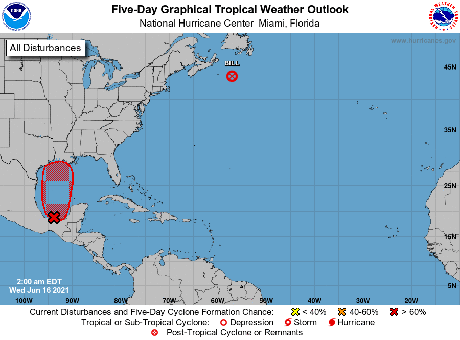
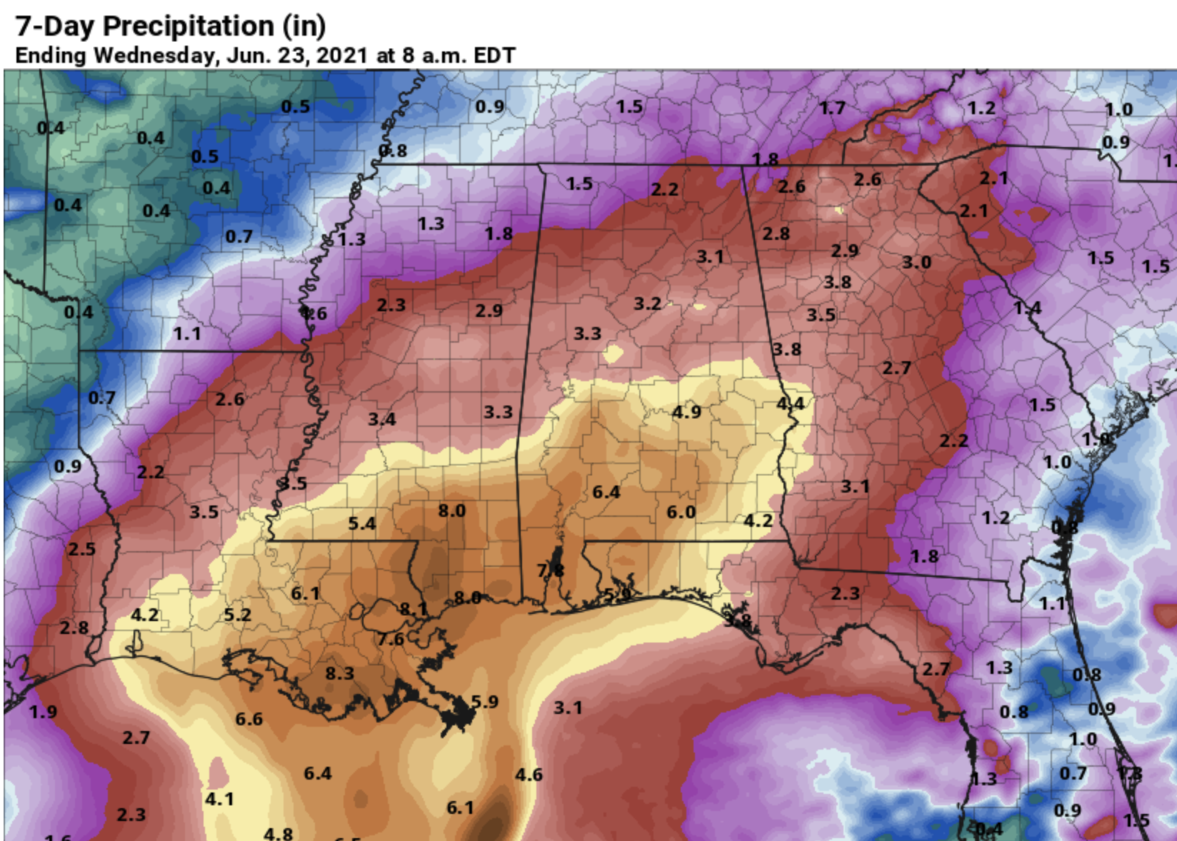
The depression will move in the general direction of the Louisiana coast by Friday night or Saturday morning, and will bring potential for heavy rain to the coasts of Louisiana, Mississippi, and the Florida Panhandle. Rain amounts of 4-8 inches are likely in the broad zone from Morgan City to Panama City Beach, and the rip current danger will be high Friday and over the weekend; expect double red flags. The weather on the Gulf Coast will begin to improve Monday.
ON THIS DATE IN 1896: A tsunami ravages the coast of Japan killing between 22,000 and 27,000 people.
BEACH FORECAST: Click here to see the AlabamaWx Beach Forecast Center page.
WEATHER BRAINS: Don’t forget you can listen to our weekly 90 minute show anytime on your favorite podcast app. This is the show all about weather featuring many familiar voices, including our meteorologists here at ABC 33/40.
CONNECT: You can find me on all of the major social networks…
Look for the next Weather Xtreme video here by 3:00 this afternoon… enjoy the day!
Category: Alabama's Weather, ALL POSTS, Weather Xtreme Videos
About the Author (Author Profile)
James Spann is one of the most recognized and trusted television meteorologists in the industry. He holds the AMS CCM designation and television seals from the AMS and NWA. He is a past winner of the Broadcast Meteorologist of the Year from both professional organizations.Subscribe
If you enjoyed this article, subscribe to receive more just like it.


