Occasional Showers/Storms Through Mid-Week; Drier This Weekend
UNSETTLED WEATHER CONTINUES: A layer of deep moisture remains over Alabama this morning, and with a broad upper trough nearby, we expect occasional showers and thunderstorms to continue through mid-week. Understand there will be some good breaks in the rain, and you might see the sun at times, but when showers and storms do form they will be very efficient rain producers in this kind of airmass.
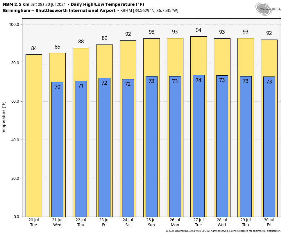
NWS Huntsville maintains a flash flood watch for the Tennessee Valley of North Alabama, but any part of the state could see some localized flooding issues where heavier storms develop later today. The high today and tomorrow will be in the low 80s, followed by mid 80s Thursday.
For Friday, we expect a mix of sun and clouds with scattered to numerous showers and thunderstorms, especially during the afternoon and evening hours. Friday’s high will be in the upper 80s.
THE ALABAMA WEEKEND: A pattern change begins, and the weather trends hotter and drier. As an upper ridge builds with warmer air aloft and a more stable airmass, we expect a good supply of sunshine Saturday and Sunday with only widely scattered showers and thunderstorms during the afternoon and evening hours. Highs will be in the 89-92 degree range, close to seasonal averages for late July in Alabama.
NEXT WEEK: The ridge will continue to grow stronger, and the week will be hot and mostly dry with only isolated showers and storms around each afternoon. Afternoon temperatures climb into the low to mid 90s… See the Weather Xtreme video for maps, graphics, and more details.
MONDAY’S RAIN: Here are rain totals across North/Central Alabama, thanks to the team of ABC 33/40 Skywatchers…
Rock Creek 5.52″
Virginia Mines/Hueytown 5.32″
Bluff Park 4.79″
Moody 4.13″
Hueytown 3.91″
Oak Grove 3.26″
Crestwood 3.09″
Trussville 2.90″
Bessemer 2.48″
Lay Lake 2.10″
Morris 1.99″
Vance 1.80″
Margaret 1.73″
Pell City 1.63″
Jacksonville 1.43″
Bibbville 1.36″
Egypt 1.29″
Alabaster 1.26″
Heflin 1.21″
Oneonta 1.19″
Remlap 1.07″
Rainbow City .97″
Carbon Hill .75″
Coker .73″
Weaver .71″
Arley .55″
Cottondale .37″
HOW DOES THIS JULY COMPARE? Birmingham’s official rain total yesterday was 2.24″. Not a daily record… the record rain for July 19 came in 1897 when the total was 2.95″.
The total for July is up to 6.07″. Are we headed for the wettest July on record? Probably not even close. Here are our wettest months of July on record since 1900…
July 1916 20.12″
July 1950. 13.70″
July 1910. 10.80″
July 1941 10.33″
July 1961 10.17″
July 1985 10.07″
TROPICS: All remains quiet across the Atlantic basin, and tropical storm formation is not expected through the weekend.
BEACH FORECAST: Click here to see the AlabamaWx Beach Forecast Center page.
WEATHER BRAINS: Don’t forget you can listen to our weekly 90 minute show anytime on your favorite podcast app. This is the show all about weather featuring many familiar voices, including our meteorologists here at ABC 33/40.
CONNECT: You can find me on all of the major social networks…
Look for the next Weather Xtreme video here by 3:00 this afternoon… enjoy the day!
Category: Alabama's Weather, ALL POSTS, Weather Xtreme Videos
About the Author (Author Profile)
James Spann is one of the most recognized and trusted television meteorologists in the industry. He holds the AMS CCM designation and television seals from the AMS and NWA. He is a past winner of the Broadcast Meteorologist of the Year from both professional organizations.Subscribe
If you enjoyed this article, subscribe to receive more just like it.


