Scattered Showers/Storms Develop Later Today
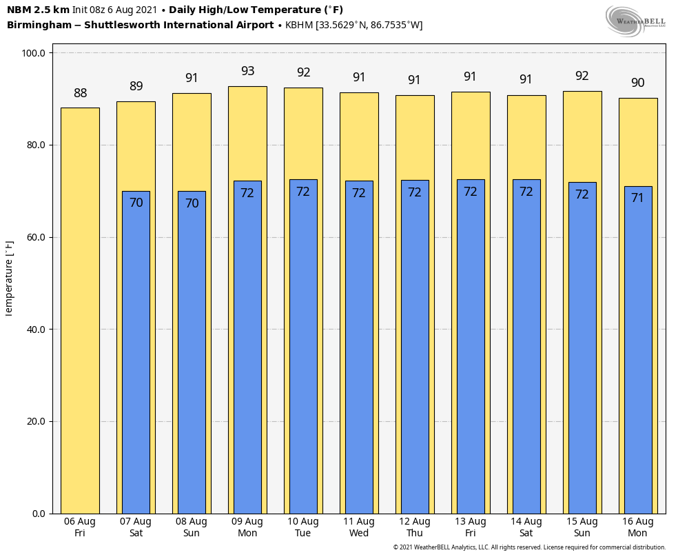
SUN AND STORMS: An upper trough will bring an increase in the number of scattered showers and thunderstorms to Alabama today and tomorrow, but it still won’t rain everywhere. The chance of any one spot getting wet is 30-40 percent, and most of the showers will come from about 1:00 until 10:00 p.m. Otherwise, look for a mix of sun and clouds with a high in the 86-90 degree range. Then, on Sunday, showers become fewer in number as an upper ridge begins to build over the region. Sunday’s high will be at or just over 90 degrees with a partly sunny sky.
NEXT WEEK: The weather won’t change much… very typical conditions for August. Partly sunny days with a few widely scattered, mostly afternoon and evening showers and thunderstorms around on a daily basis. Afternoon highs will be in the low 90s, right at seasonal levels. See the Weather Xtreme video for maps, graphics, and more details.
TROPICS: A disturbance located over the central tropical Atlantic continues to produce some disorganized showers and thunderstorms. This system is expected to move west-northwestward at 10 to 15 mph, and some slow development is possible early next week when it is expected to be near the Lesser Antilles. For now the chance of development with this feature is only 20 percent over the next five days.
Out in the far eastern Atlantic, a large area of disorganized showers and thunderstorms located a few hundred miles south-southeast of the Cabo Verde Islands is associated with a tropical wave interacting with a broader surface trough. Environmental conditions appear somewhat conducive for gradual development, and a tropical depression is likely to form this weekend or early next week while the system moves generally west-northwestward across the eastern tropical Atlantic. The name will be “Fred” if this reaches tropical storm strength; way too early to know if it will impact any land areas.
The Gulf of Mexico and the western Atlantic basin remain quiet this morning.
ON THIS DATE IN 1993: Virginia experienced its worst tornado outbreak ever as 18 tornadoes ripped through the state in 5 hours. The most devastating tornado caused severe damage in the historic part of Petersburg. The storm then moved on to Pocahontas Island and into Colonial Heights. There, the storm ripped apart a Walmart, killing three people and injuring nearly 200. The F4 twister was the first known violent tornado in Virginia history. It killed a total of 4 people and injured 246 along its 12-mile path.
BEACH FORECAST: Click here to see the AlabamaWx Beach Forecast Center page.
WEATHER BRAINS: Don’t forget you can listen to our weekly 90 minute show anytime on your favorite podcast app. This is the show all about weather featuring many familiar voices, including our meteorologists here at ABC 33/40.
CONNECT: You can find me on all of the major social networks…
Look for the next Weather Xtreme video here by 3:00 this afternoon… enjoy the day!
Category: Alabama's Weather, ALL POSTS, Weather Xtreme Videos
About the Author (Author Profile)
James Spann is one of the most recognized and trusted television meteorologists in the industry. He holds the AMS CCM designation and television seals from the AMS and NWA. He is a past winner of the Broadcast Meteorologist of the Year from both professional organizations.Subscribe
If you enjoyed this article, subscribe to receive more just like it.


