Midday Nowcast: Oh So Nice!!!
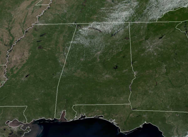
Weather like this is what I say is the southern’s reward for surviving a long, hot, and very humid summer…It just doesn’t get any better than this in my opinion. For today and through the weekend, fantastic fall weather will continue. The days will be sunny, with low humidity and highs today and tomorrow will be in the low to upper 70s across the state, with lower 80s likely Saturday and Sunday. Tonight will be another chilly one as lows are likely to fall into the 40s for many, with 50s elsewhere. The nights through the weekend will remain refreshing with 50s in the forecast.
FOOTBALL WEATHER: Perfect weather for the high school games across Alabama tonight and tomorrow night; clear and cool with temperatures falling through the 60s.
GEORGIA STATE AT AUBURN (3p CT kickoff at Jordan-Hare Stadium): A clear sky with temperatures falling from near 80 degrees at kickoff into the low 70s by the final whistle.
SOUTHERN MISS AT ALABAMA (6:30p CT kickoff at Bryant-Denny Stadium): Clear and very pleasant. Kickoff temperature near 78 degrees, falling into the upper 60s by the fourth quarter.
UAB AT TULANE (7p CT kickoff at Yulman Stadium in New Orleans): A clear sky with temperatures falling from 77 degrees at kickoff to near 70 by the final whistle.
UT-MARTIN AT JACKSONVILLE STATE (3p CT kickoff at Burgess-Snow Field): A beautiful day; the sky will be clear with temperatures falling from 79 degrees at kickoff to near 70 by the end of the game.
TROY AT LA-MONROE (7p CT kickoff at Monroe, LA): The sky will be clear with temperatures falling from near 80 at kickoff, into the upper 60s by the final whistle.
NEXT WEEK: Temperatures will moderate some as we roll into next week, but should be pretty close to seasonal averages with afternoon highs in the low to mid 80s, while nights will be close to 60°. Humidity levels will remain low, and with low moisture levels, rain is not in the forecast. It looks to be October before the threat of widespread rain returns to the forecast in Alabama.
IN THE TROPICS: Tropical Depression Eighteen become Tropical Storm Sam this morning. The center of Tropical Storm Sam was located near latitude 10.9 North, longitude 38.1 West. Sam is moving toward the west near 16 mph and this general motion is expected to continue over the next several days, but with a gradual slowdown in forward motion.
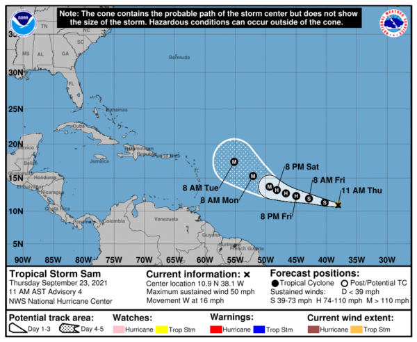
Recent satellite wind data indicates maximum sustained winds have increased to near 50 mph with higher gusts. Additional strengthening is forecast over the next several days, and Sam is now forecast to become a hurricane tomorrow and be near major hurricane intensity by the end of the weekend. Tropical-storm-force winds extend outward up to 45 miles from the center. The estimated minimum central pressure is 1003 mb (29.62 inches).
The National Hurricane Center has issued the last advisory on Post-Tropical Cyclone Rose, located more than 1300 miles west-northwest of the Cabo Verde Islands.
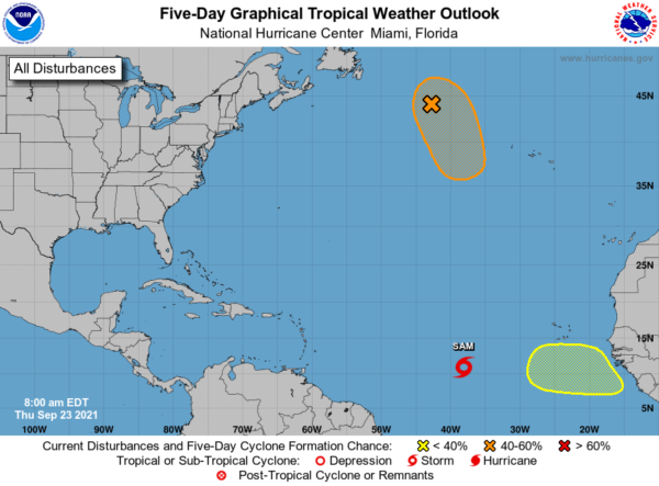
1. A gale-force, non-tropical low pressure system, the remnants of Odette, is located a little more than 600 miles west-northwest of the westernmost Azores. While showers and thunderstorms remain limited near the low, only a small increase in this activity could result in the formation of a subtropical or tropical cyclone while it moves generally southward over marginally warmer waters during the next day or two. Strong upper-level winds are expected to develop over the system by this weekend, which should then limit. Formation chance through 5 days…medium…60 percent.
2. Another tropical wave is expected to move off the west coast of Africa by the end of the weekend. Thereafter, environmental conditions are forecast to be conducive for gradual development of this system as it moves westward at 10 to 15 mph over the far east Atlantic. Formation chance through 5 days…low…20 percent.
BEACH FORECAST CENTER: Get the latest weather and rip current forecasts for the beaches from Fort Morgan to Panama City on our Beach Forecast Center page. There, you can select the forecast of the region that you are interested in visiting.
WORLD TEMPERATURE EXTREMES: Over the last 24 hours, the highest observation outside the U.S. was 112.1F at Reggane, Algeria. The lowest observation was -92.9F at Vostok, Antarctica.
CONTIGUOUS TEMPERATURE EXTREMES: Over the last 24 hours, the highest observation was 108F at Palm Springs, CA. The lowest observation was 11F at Peter Sinks, UT.
WEATHER ON THIS DATE IN 2005: Hurricane Rita reached the Texas/Louisiana border area near Sabine Pass as a category-3 hurricane with maximum sustained winds near 120 mph. A storm surge of at least 15 feet flooded parts of Cameron, Jefferson Davis, Terrebonne and Vermilion parishes, where sugar cane crop losses were estimated near $300 million. An 8-foot storm surge in New Orleans overtopped the provisionally-repaired levees (from Hurricane Katrina damage) and caused additional flooding. A total of 10 fatalities were reported, and preliminary damage estimates ranged between $4-5 billion.
Category: Alabama's Weather, ALL POSTS
About the Author (Author Profile)
Macon, Georgia Television Chief Meteorologist, Birmingham native, and long time Contributor on AlabamaWX. Stormchaser. I did not choose Weather, it chose Me. College Football Fanatic. @Ryan_StinnetSubscribe
If you enjoyed this article, subscribe to receive more just like it.


