Highs In The 80s Through Friday; Much Cooler This Weekend
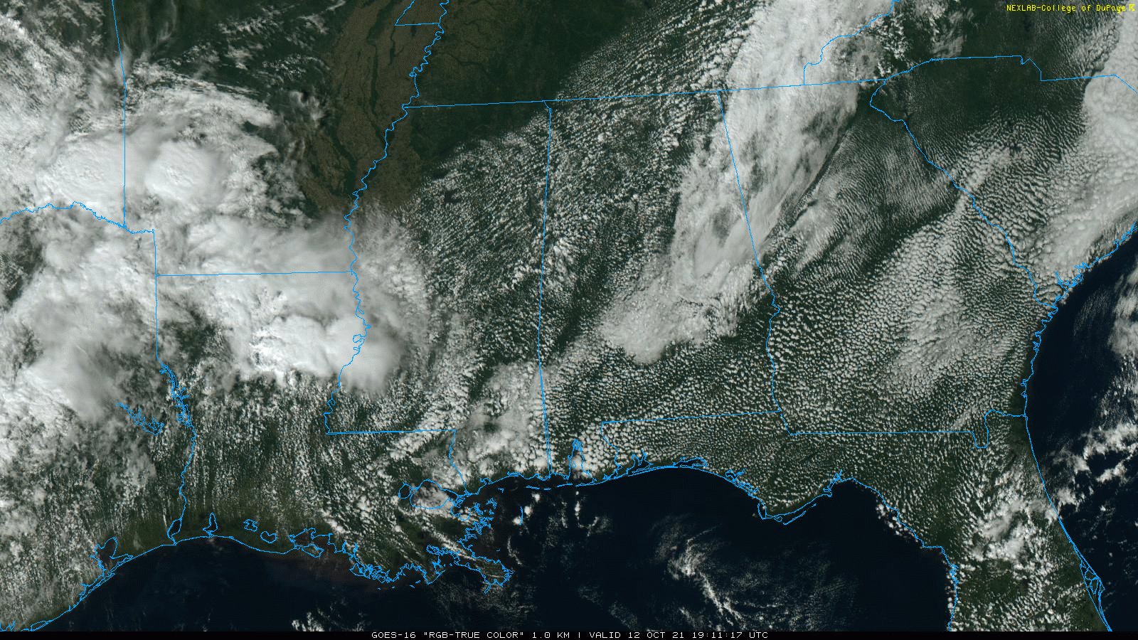
RADAR CHECK: Showers are almost impossible to find across Alabama this afternoon, despite a surface front nearby that is stalled out near the northwest corner of the state. We have a mix of sun and clouds, and temperatures are mostly in the low to mid 80s. A few spotty showers could still develop this evening, but most places will remain dry tonight.
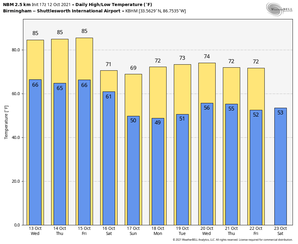
Our weather will be warm and dry tomorrow and Thursday… the sky will be partly to mostly sunny both days with highs between 84 and 87 degrees.
FRIDAY AND THE WEEKEND: The day Friday will be warm and dry with a high in the 83-86 degree range. Clouds will increase late in the day, and showers are possible Friday night ahead of a sharp cold front that will bring a big weather change for the weekend. Rain amounts Friday night will be light with limited moisture, and there is no risk of severe storms. For now it looks like the best chance of showers will come from about 6:00 p.m. Friday through 8:00 a.m. Saturday.
Rain ends early Saturday morning… the sky becomes partly to mostly sunny, and the day will be much cooler with a high between 68 and 72 degrees. A north wind of 10-20 mph will make it feel cooler. Then, temperatures will drop into the 40s early Sunday morning with a clear sky and diminishing wind. Sunday will be a picture perfect autumn day with sunshine in full supply along with a high around 70 degrees.
NEXT WEEK: Global models continue to suggest next week will be dry with very pleasant days and cool nights… highs in the 70s and lows in the 50s. See the Weather Xtreme video for maps, graphics, and more details.
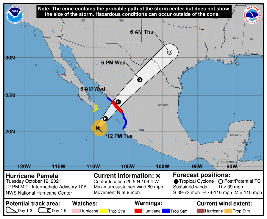
TROPICS: The Atlantic basin remains quiet today, and tropical storm formation is not expected through the weekend. Over in the eastern Pacific, Pamela is now a hurricane, and the center is about 260 miles southwest of Mazatlan, Mexico. Sustained winds are 80 mph, and landfall is expected on the Pacific Coast of Mexico after midnight tonight.
While the system will rapidly weaken over Mexico tomorrow, moisture from Pamela will move into Texas Thursday, with potential for heavy rain in a broad zone from Del Rio to Dallas/Fort Worth.
GEOMAGNETIC STORM: A G2, “moderate” geomagnetic storm impacted the high latitudes last night and early this morning. A vivid display of the Northern Lights were seen over most of Canada and the far northern U.S. The storm was sparked by a CME, a Coronal Mass Ejection. This is a large expulsion of plasma and magnetic field from the Sun’s corona.
ON THIS DATE IN 1979: The lowest barometric pressure ever recorded occurs in the center of Typhoon Tip on this day. A fly reconnaissance mission recorded the low pressure of 870 hPa or 25.69 inHg. Typhoon Tip was the most extensive tropical cyclone on record with a wind diameter of 1380 miles at its peak.
BEACH FORECAST: Click here to see the AlabamaWx Beach Forecast Center page.
WEATHER BRAINS: Don’t forget you can listen to our weekly 90 minute show anytime on your favorite podcast app. This is the show all about weather featuring many familiar voices, including our meteorologists here at ABC 33/40.
CONNECT: You can find me on all of the major social networks…
Look for the next Weather Xtreme video here by 6:00 a.m. tomorrow…
Category: Alabama's Weather, ALL POSTS, Weather Xtreme Videos
About the Author (Author Profile)
James Spann is one of the most recognized and trusted television meteorologists in the industry. He holds the AMS CCM designation and television seals from the AMS and NWA. He is a past winner of the Broadcast Meteorologist of the Year from both professional organizations.Subscribe
If you enjoyed this article, subscribe to receive more just like it.


