Rain Arrives Late Tonight; Big Cooling Trend Tomorrow/Friday
CLOUDS MOVING IN THIS AFTERNOON: After a mostly sunny start, clouds will move into Alabama this afternoon ahead of a dynamics weather system to the west producing rain and storms over Arkansas and Louisiana. Strong to severe storms are possible over parts of South and Southwest Alabama tonight… SPC maintains a “slight risk” (level 2/5) for most of Mobile, Baldwin and Escambia counties, with a “marginal risk” (level 1/5) as far north and east as Sweetwater, Greenville and Ozark.
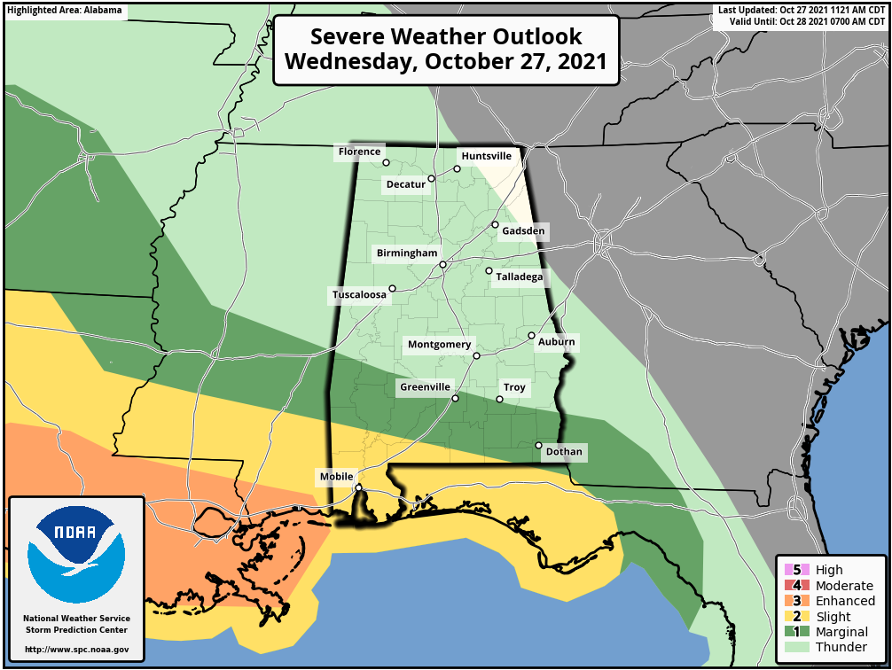
Storms over South Alabama late tonight will be capable of producing damaging winds and a few tornadoes. For the rest of Alabama, rain will arrive after midnight, but no severe storms are expected over the northern half of the state.
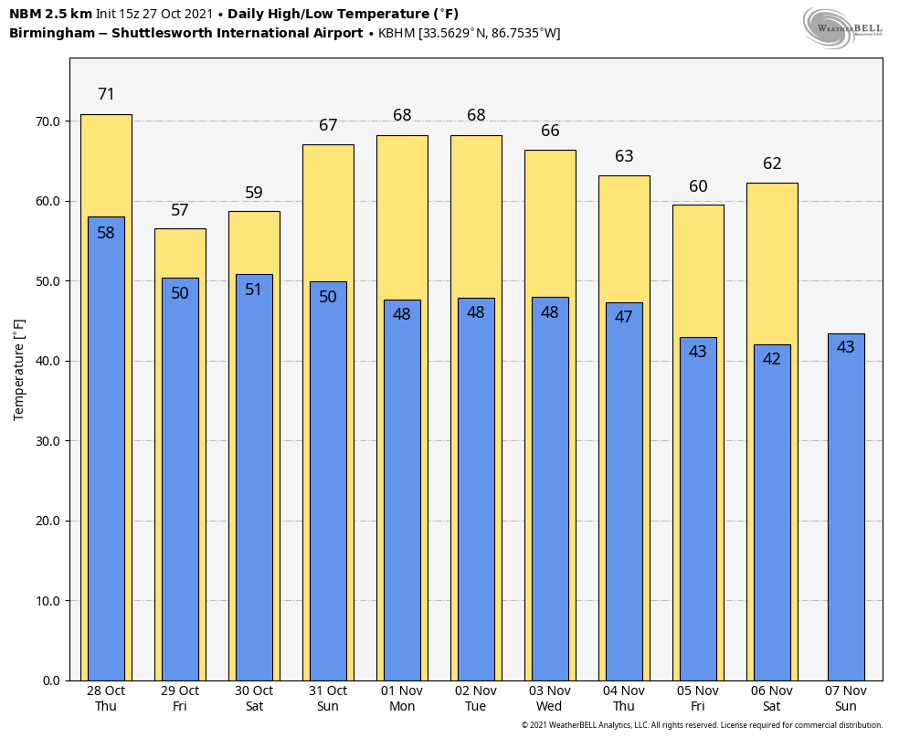
TOMORROW/FRIDAY: The weather turns colder as a deep upper low develops over the region, we will hover in the low 60s tomorrow, and by Friday most places in North Alabama won’t get past the mid 50s… 20 degrees below average for late October. The sky will be cloudy both days with occasional light rain or drizzle over the northern half of the state. A little sun is possible for South Alabama.
HALLOWEEN WEEKEND: While South Alabama should be mostly sunny Saturday, clouds will hang tough over the northern counties some a little light rain or drizzle still possible, mainly in areas north and east of Birmingham…. the high will be in the low 60s over North Alabama, and close to 70 for the southern half of the state. Then, expect sunshine in full supply statewide Sunday with a high between 68 and 73 degrees.
NEXT WEEK: The latest global model data suggests the weather will remain dry Monday and Tuesday… then a batch of showers will likely arrive late Wednesday or Wednesday night, followed by another shot of cooler air. Highs during the week will be mostly in the 60s, with lows in the 40s. See the Weather Xtreme video for maps, graphics, and more details.
TROPICS: A deep, non-tropical low pressure system with storm-force winds is located about 100 miles east-southeast of Cape Cod, Massachusetts. The extratropical low is expected to meander off of the mid-Atlantic and northeastern U.S. coasts through the evening hours, bringing rain and wind impacts to portions of those areas. Then, the low is expected to move eastward away from the United States, and it could acquire some subtropical characteristics while it moves eastward or southeastward over the warmer waters of the central Atlantic through this weekend. The rest of the Atlantic basin is quiet.
FOOTBALL WEATHER: For the high school games Friday night, the sky will be cloudy with some light rain possible; temperatures will hover around 50 degrees at most stadiums.
For the college games Saturday…
WEST ALABAMA AT NORTH GREENVILLE (11:00a CT kickoff at Tigerville, SC): The sky will be mostly cloudy with a few passing showers possible during the game; temperatures will be in the 58-62 degree range.
SAMFORD AT VMI (12:30p CT kickoff at Lexington, VA): Expect a cloudy sky with a chance of rain at times… temperatures will be in the mid to upper 50s.
CENTRAL ARKANSAS AT JACKSONVILLE STATE (1:00p CT kickoff at Burgess Snow Field): The sky will be mostly cloudy with a little light rain or drizzle possible; temperatures will be in the 55-59 degree range during the game.
BIRMINGHAM SOUTHERN AT BERRY COLLEGE (3:00p CT kickoff at Mt. Berry, GA): A cloudy sky during the game with some light rain possible; temperatures will be in the mid to upper 50s.
ARKANSAS STATE AT SOUTH ALABAMA (4:00p CT kickoff at Hancock Whitney Stadium): The sky will be mostly fair with temperatures falling from near 68 at kickoff, into the 50s by the second half.
OLE MISS AT AUBURN (6:00p CT kickoff at Jordan-Hare Stadium): Mostly fair with temperatures falling from near 54 degrees at kickoff, into the upper 40s by the second half.
ON THIS DATE IN 2006: An F1 tornado (waterspout) came ashore and caused significant damage on the west side of Apalachicola Florida.
BEACH FORECAST: Click here to see the AlabamaWx Beach Forecast Center page.
WEATHER BRAINS: Don’t forget you can listen to our weekly 90 minute show anytime on your favorite podcast app. This is the show all about weather featuring many familiar voices, including our meteorologists here at ABC 33/40.
CONNECT: You can find me on all of the major social networks…
Look for the next Weather Xtreme video here by 6:00 a.m. tomorrow…
Category: Alabama's Weather, ALL POSTS, Weather Xtreme Videos
About the Author (Author Profile)
James Spann is one of the most recognized and trusted television meteorologists in the industry. He holds the AMS CCM designation and television seals from the AMS and NWA. He is a past winner of the Broadcast Meteorologist of the Year from both professional organizations.Subscribe
If you enjoyed this article, subscribe to receive more just like it.


