Cool, Dry Day For North/Central Alabama
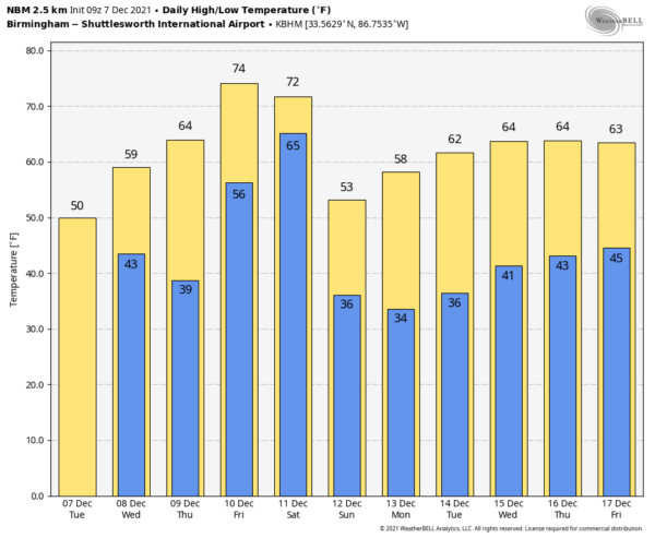
ON THE MAPS: A cold front is stalled out over Southeast Alabama early this morning; south of the front Dothan reports 60 degrees, but most communities over the northern half of the state are in the 30s, and a few spots are at freezing. Today will be mostly cloudy and cool with a high in the 48-52 degree range for North/Central Alabama… the average high for Birmingham on December 7 is 59. A few showers are possible today over South Alabama near the stalled front.
A wave of low pressure will move along the front tonight, and showers are possible statewide after midnight and into tomorrow morning. Then, a decent chance we see some sun tomorrow afternoon as the wave moves east of the state. The high tomorrow. will be in the low 60s over North Alabama, and closer to 70 over the southern third of the state.
Thursday will be a warmer day with a mix of sun and clouds… the high will be in the upper 60s and any showers during the day should be widely spaced. Then, on Friday, temperatures will surge into the mid 70s, very close to record levels. Birmingham’s record high for December 10 is 79 set in 2007. Scattered showers and storms are possible Friday, but it won’t rain all day.
THE ALABAMA WEEKEND: A cold front will bring an organized rain event to the state Saturday into Saturday night. It is still a little too early to be really specific on timing (many outdoor events are scheduled, like Christmas parades), but the broad window for rain will come from 6am until 12 midnight. The rain could be heavy at times, and with an unstable airmass in place the door is open for strong thunderstorms. For now, the severe weather threat doesn’t look especially high; it could very well be an event like we experienced yesterday. SPC doesn’t have any area outlooked for severe storms on Saturday at this point.
The day will be mild with a high in the 67-70 degree range. Rain will end late Saturday night, and Sunday will be a much brighter day with sunshine back in full force. The day will be significantly cooler with a high in the 52-55 degree range.
NEXT WEEK: A ridge aloft will build over the Gulf Coast region, and at this point the week looks rain-free with pleasant days and chilly nights. The high Monday will be in the upper 50s, followed by 60s for the rest of the week. And, we should note long guidance suggests above average temperatures for much of the eastern half of the U.S. December 14-20. See the Weather Xtreme video for maps, graphics, and more details.
MONDAY’S RAIN: Rain totals from the ABC 33/40 Skywatchers yesterday included…
Cottondale 1.37″
Bessemer 1.10″
Bluff Park 1.10″
Coker 1.09″
Arley 1.08″
West Blocton 1.07″
Crestwood 1.05″
Moody 1.04″
Mountain Brook 0.96″
Jemison 0.76″
Weaver 0.74″
Lay Lake 0.69″
Oneonta 0.68″
Heflin 0.64″
Rainbow City 0.61″
ON THIS DATE IN 1951: It was the warmest December day on record for most of Alabama. Montgomery soared to 83 degrees. Other highs included 80 at Birmingham and Anniston, 79 in Tuscaloosa, and 78 in Huntsville.
ON THIS DATE IN 2006: A rare tornado tore through Kensal Rise in London. This T4 on the TORRO scale, equivalent to an EF2 on the Fujita scale, injured six people and damaged 150 homes. According to the BBC, the last tornado which caused significant damage in London was in December 1954, in West London.
BEACH FORECAST: Click here to see the AlabamaWx Beach Forecast Center page.
WEATHER BRAINS: Don’t forget you can listen to our weekly 90 minute show anytime on your favorite podcast app. This is the show all about weather featuring many familiar voices, including our meteorologists here at ABC 33/40.
CONNECT: You can find me on all of the major social networks…
Look for the next Weather Xtreme video here by 3:00 this afternoon… enjoy the day!
Category: Alabama's Weather, ALL POSTS, Weather Xtreme Videos


