Strong/Severe Storms Push Into Alabama Tomorrow Morning
THIS AFTERNOON: A warm front continues to push across Alabama, and we have a big temperature spread at mid-afternoon. Tuscaloosa reports 75 degrees at 2pm with a dew point of 70, but cooler air is still across Northeast Alabama, where Gadsden reports 55 degrees. The sky is mostly cloudy over the northern half of the state, and a few spotty showers are moving northeast. The warm, unstable air will finally push into the northeast counties of the state tonight, and winds will increase as a cold front approaches.
A wind advisory is in effect for about the northern third of Alabama tonight and tomorrow morning… southerly winds will average 12-22 mph with gusts to 30 mph possible. Be sure and secure any outdoor Christmas decorations that might go flying away.
Northwest of Alabama, severe storms will form tonight over parts of Arkansas, Missouri, West Tennessee, West Kentucky, and North Mississippi ahead of the front. There is now a “moderate risk” (level 4/5) defined for parts of AR/TN/MO/KY/IL/KY.
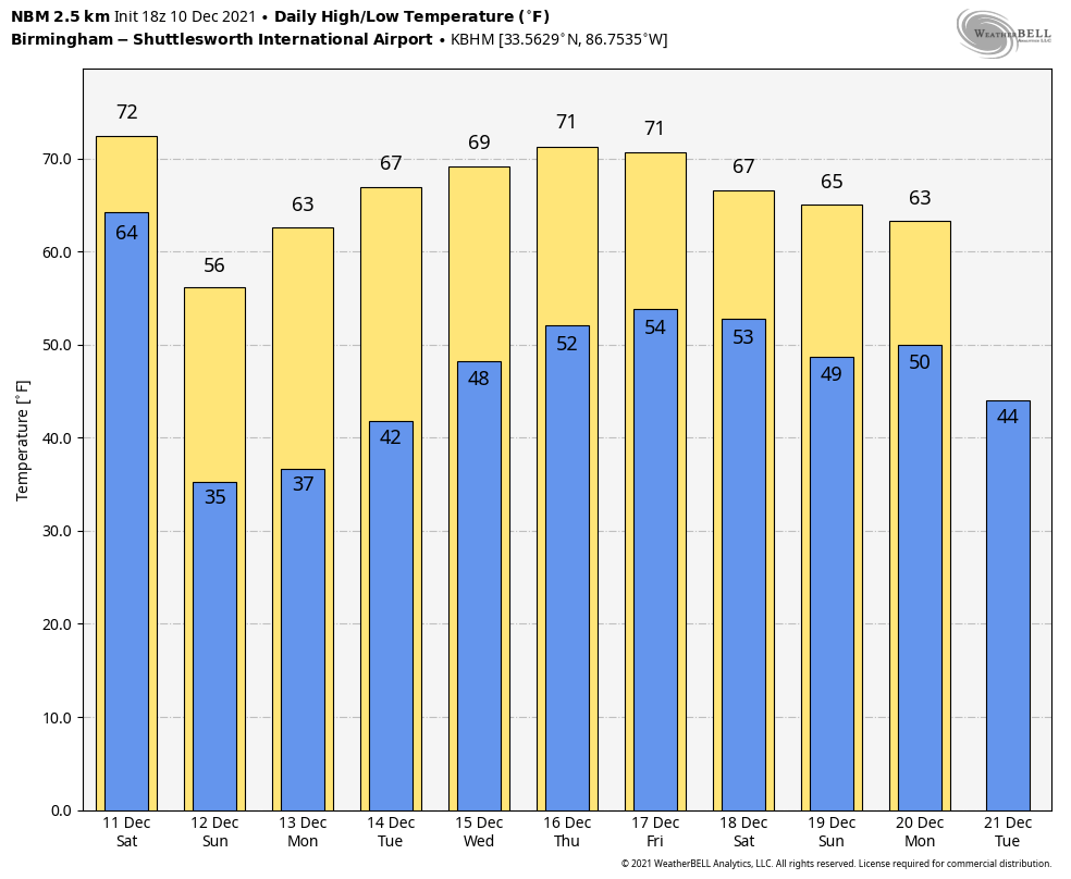
STORMY SATURDAY: Storms northwest of Alabama will evolve into a long squall line, and it will enter the northwest corner of the state early tomorrow morning. The line will pass through the state during the day, followed by falling temperatures. We will be close to 70 degrees as the day begins, but temperatures will fall through the 50s following the passage of the line of storms.
SPC has a “slight risk” (level 2/5) defined for that part of Alabama northwest of a line from Scottsboro to Cullman to Aliceville. A “marginal risk” (level 1/5) is defined as far south as Eufaula, Troy, Evergreen, and Mobile.
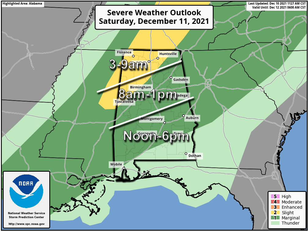
TIMING: The line of strong to severe storms will likely enter the northwest corner of Alabama around 3:00-5:00 a.m. tomorrow. The line should reach the Birmingham/Anniston/Gadsden/Tuscaloosa areas around 11:00-1:00. Then, after 1:00 the line will move south of I-20, pushing into the southern counties by mid to late afternoon. The severe weather threat will is not as great for South Alabama as dynamic support will be weakening by then.
THREATS: For Alabama, the main threat will come from strong, potentially damaging straight line winds. A few isolated tornadoes can’t be ruled out, however. Rain will be briefly heavy, but flooding is not expected.
CALL TO ACTION: Be sure you have a way of hearing severe weather warnings. Your primary source should NEVER be an outdoor siren. Have a NOAA Weather Radio in your home properly programmed with a fresh battery in case of power failure. Be sure emergency alerts are enabled on your phone. And, review your severe weather plan; identify the safe place and be sure everyone knows where it is. And, if you live in a mobile home, know where you will go in case you fall in a tornado warning polygon.
The sky will clear tomorrow night as dry air return to the state. Sunday will be a sunny, cool day with a high in the 55-60 degree range.
NEXT WEEK: The week will be generally dry and pleasant thanks to an upper high forming over the Gulf Coast region. Highs will be in the 60s Monday through Wednesday… and close to 70 Thursday and Friday. A few showers could show late in the week on Friday, but nothing too heavy or widespread. And, the latest CPC outlook suggests temperatures will remain above average across Alabama December 18-24. See the Weather Xtreme video for maps, graphics, and more details.
ON THIS DATE IN 2008: An EF-1 tornado moved through Oakman, in Walker County. The tornado touched down just west of Jackson Street on the north side of Oakman. The tornado traveled northeastward and crossed School Street and State Highway 69. The tornado lifted on Watts Street just east of State Highway 69. Metal bleachers were twisted and thrown at the Oakman School athletic field. Several houses suffered significant roof damage along State Highway 69. Approximately 150 trees were either uprooted or snapped off. Little structural damage occurred at the school, but water damage was sustained.
ON THIS DATE IN 2012: An EF-1 tornado passed just north of downtown Birmingham causing damage to 29 homes, 2 of which had major damage and one of which lost its roof entirely. A church and two other businesses were damaged near the intersection of Finley Blvd and 16th Street. The tornado lifted near the intersection of 24th Court North and 18th Street North, just west of Interstate 65.
BEACH FORECAST: Click here to see the AlabamaWx Beach Forecast Center page.
WEATHER BRAINS: Don’t forget you can listen to our weekly 90 minute show anytime on your favorite podcast app. This is the show all about weather featuring many familiar voices, including our meteorologists here at ABC 33/40.
CONNECT: You can find me on all of the major social networks…
Look for my next Weather Xtreme video here by 6:00 a.m. Monday… enjoy the weekend!
Category: Alabama's Weather, ALL POSTS, Weather Xtreme Videos
About the Author (Author Profile)
James Spann is one of the most recognized and trusted television meteorologists in the industry. He holds the AMS CCM designation and television seals from the AMS and NWA. He is a past winner of the Broadcast Meteorologist of the Year from both professional organizations.Subscribe
If you enjoyed this article, subscribe to receive more just like it.


