Windy Day Tomorrow; Severe Storms Possible By Mid To Late Afternoon
SPRING-LIKE AFTERNOON: Temperatures are in the 68-74 degree range across Alabama this afternoon with a partly sunny sky. Clouds will increase tonight ahead of the approaching storm system.
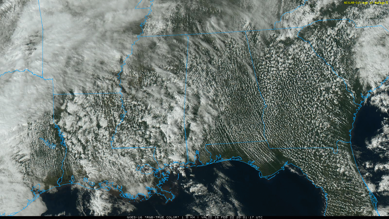
ACTIVE DAY TOMORROW: A dynamic storm system will bring lots of wind, and the threat of severe thunderstorms to Alabama and much of the Deep South tomorrow. The main limiting factor continues to be weak instability, but other parameters are very favorable for severe thunderstorms.
SPC has upgraded parts of North and West Alabama to an “enhanced risk” (level 3/5)… this is for areas west of a line from Hypo to Hueytown to Demopolis. There is a “slight risk” (level 2/5) as far east as Weiss Lake, Rockford, Camden, and Chatom. The rest of the state (East/South Alabama) is in a “marginal risk” (level 1/5).
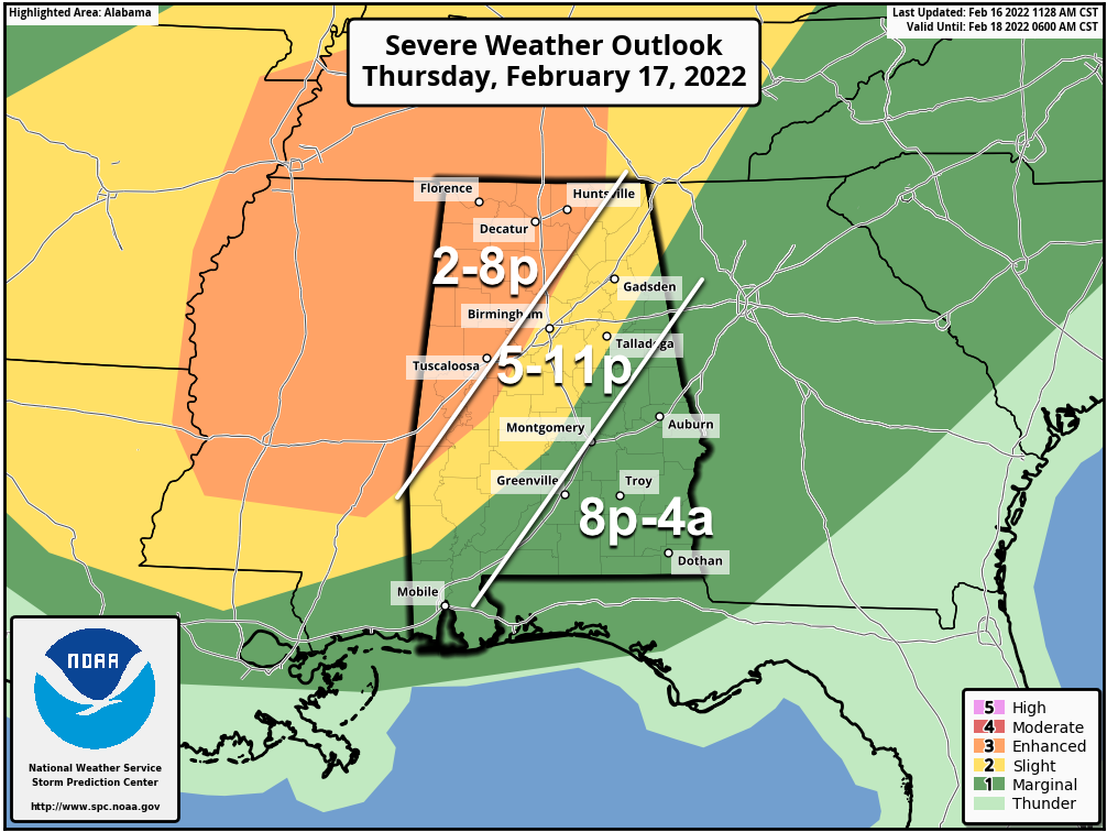
TIMING: The window for strong to severe thunderstorms will open up around 2:00 p.m. over the far western part of the state… in the “enhanced risk” area the main threat comes from 2:00 until 8:00 p.m. For Birmingham, Anniston, and Gadsden… the main window will be from 5:00-11:00 p.m. Strong storms could linger across Southeast Alabama well past midnight.
THREATS: Storms tomorrow afternoon and tomorrow night will be capable of producing hail, strong straight line winds, and a few tornadoes. The highest risk of a tornado is in the “enhanced risk” area across North and West Alabama.
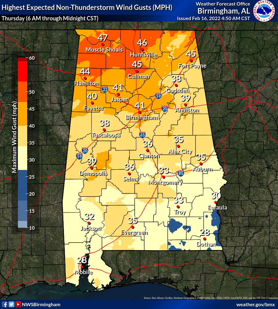
GRADIENT WIND: Non-thunderstorm winds will average 15-30 mph, with gusts to 40 mph in spots during the afternoon and evening hours. These winds could knock down a few trees and power lines.
RAIN: Rain amounts around one inch are likely… a few spots could see around 1.5″. For now significant flooding issues are not expected.
Events like this are fairly common in February in Alabama… we are in the tornado season (November through May). Be sure you have a reliable way of hearing warnings (NEVER an outdoor siren), and know your safe place. If you live in a mobile home, know where you are going if you fall in a tornado warning polygon, and the quickest way of getting there.
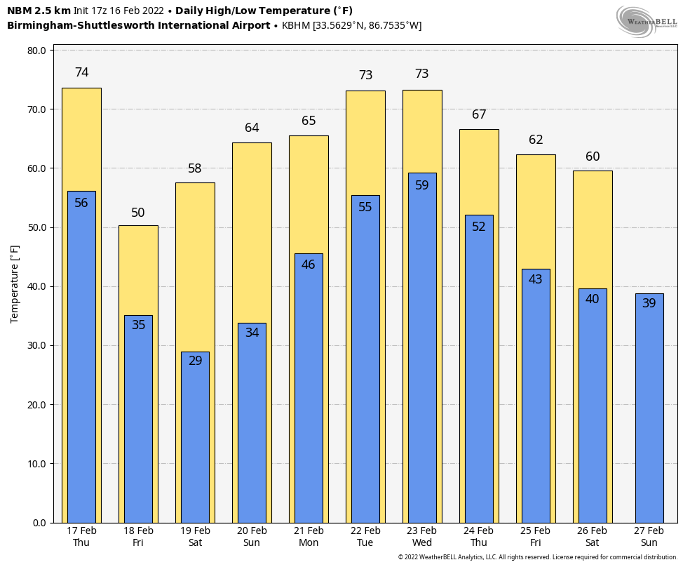
FRIDAY AND THE WEEKEND: The sky becomes partly to mostly sunny Friday, and the day will be considerably cooler with a high at or just over 50 degrees. The weekend will feature sunny days with a warming trend… the high Saturday will be in the upper 50s, followed by mid 60s Sunday.
NEXT WEEK: Rain will return to the state Monday, and it looks like we will have some risk of rain on a daily basis through at least Wednesday. Temperatures will be mild… highs will likely exceed 70 degrees by Tuesday. See the Weather Xtreme video for maps, graphics, and more details.
ON THIS DATE IN 1989: A surge of arctic air on February 16-17th produced all-time record high barometric pressure readings of 31.08 inches at Duluth, Minnesota, 30.97 inches at Chicago, Illinois, and 30.94 inches at South Bend, Indiana. Readings of 31.00 inches at Milwaukee, Wisconsin, and 30.98 inches at Rockford, Illinois, tied their all-time records. Unseasonably warm weather prevailed across the southeastern U.S. Highs of 81 degrees at Athens, Georgia, 87 degrees at Charleston, South Carolina, 85 degrees at Macon, Georgia, and 86 degrees at Savannah, Georgia, were records for February.
ON THIE DATE IN 2001: A derecho (a long-lived and widespread convective wind storm) moved through Alabama. The line of storms reached the western Alabama border around 2 pm. Around the same time, a section of the squall line began to bulge out, or bow, in Pickens County. Through the next 3 hours, the derecho would move across the entire width of the state, producing wind gusts approaching 100 mph, and widespread damage similar to a F0 to F1 category. Officially recorded wind gusts include 60 mph at the Tuscaloosa and Anniston/Oxford Airports, and 68 mph at the Birmingham Airport and Gadsden/Etowah County EOC.
BEACH FORECAST: Click here to see the AlabamaWx Beach Forecast Center page.
WEATHER BRAINS: Don’t forget you can listen to our weekly 90 minute show anytime on your favorite podcast app. This is the show all about weather featuring many familiar voices, including our meteorologists here at ABC 33/40.
CONNECT: You can find me on all of the major social networks…
Look for the next Weather Xtreme video here by 6:00 a.m. tomorrow…
Category: Alabama's Weather, ALL POSTS, Weather Xtreme Videos
About the Author (Author Profile)
James Spann is one of the most recognized and trusted television meteorologists in the industry. He holds the AMS CCM designation and television seals from the AMS and NWA. He is a past winner of the Broadcast Meteorologist of the Year from both professional organizations.Subscribe
If you enjoyed this article, subscribe to receive more just like it.


