Severe Storms Possible Over Northwest Alabama This Evening/Tonight
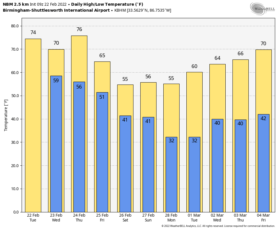
ACTIVE PATTERN CONTINUES: A warm front has moved out of Alabama early this morning; radar shows a few showers over the Tennessee Valley just before daybreak… the rest of the state is cloudy with temperatures not too far from 60 degrees. Look for a high in the mid 70s today with a few scattered showers around during the morning and midday hours. Then, strong to severe thunderstorms are possible ahead of a cold front this evening and tonight over parts of North and West Alabama.
SPC has defined a “slight risk” (level 2/5) for areas west of a line from Huntsville to Jasper to Aliceville. A “marginal risk (level 1/5) extends as far east as Rainsville, Birmingham, and Demopolis.
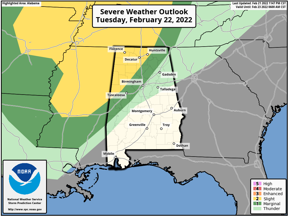
TIMING: The main window for strong to severe thunderstorms is from 5:00 p.m. until 12:00 midnight.
THREATS: Storms that form in the “slight risk” area will be capable of producing strong winds, hail, and a tornado or two. The main issue in the “marginal risk” will be gusty straight line winds, but the overall severe weather threat there is not especially high.
RAIN: Additional rain amounts will exceed one inch over North and West Alabama tonight, and a flash flood watch is in effect for areas north of a line from Millport to Cullman to Fort Payne.
As always, be sure you have a way of hearing severe weather warnings tonight if they are needed. Events like this are common in February; our tornado season runs from November through May.
REST OF THE WEEK: The front will become stationary across Central Alabama tomorrow. The high tomorrow will be in the 60s over the northern half of the state, with 70s to the south. A few showers are possible tomorrow, but they should be widely spaced. The front lifts northward tomorrow night, and Thursday will be a very mild day with a high between 74 and 78 degrees for most places. Most of the day Thursday will be dry with only isolated showers.
Another cold front will bring rain to the state after midnight Thursday night into Friday morning; severe storms are not expected. Cooler air returns Friday with afternoon temperatures hovering in the low 50s over the northern half of the state.
THE ALABAMA WEEKEND: Saturday will be a mostly cloudy day with a few scattered showers possible; the high will be close to 50 degrees. Another wave on the front to the south will bring rain Saturday night… it will end early Sunday, and the sky will clear by Sunday afternoon. Temperatures reach the mid 50s Sunday afternoon.
NEXT WEEK: For now the week looks mostly rain-free with temperatures a little below average for early March in Alabama… See the Weather Xtreme video for maps, graphics, and more details.
ON THIS DATE IN 1998: Seven tornadoes struck east-central Florida late on this date and early on the 23rd. Three of the tornadoes were rated F3 on the Fujita scale. 24 people were killed in Kissimmee alone. A total of 42 people were killed, with 265 injured, and total damage was $106 million.
BEACH FORECAST: Click here to see the AlabamaWx Beach Forecast Center page.
WEATHER BRAINS: Don’t forget you can listen to our weekly 90 minute show anytime on your favorite podcast app. This is the show all about weather featuring many familiar voices, including our meteorologists here at ABC 33/40.
CONNECT: You can find me on all of the major social networks…
Look for the next Weather Xtreme video here by 3:00 this afternoon… enjoy the day!
Category: Alabama's Weather, ALL POSTS, Weather Xtreme Videos
About the Author (Author Profile)
James Spann is one of the most recognized and trusted television meteorologists in the industry. He holds the AMS CCM designation and television seals from the AMS and NWA. He is a past winner of the Broadcast Meteorologist of the Year from both professional organizations.Subscribe
If you enjoyed this article, subscribe to receive more just like it.


