Severe Storms Possible Tomorrow Afternoon/Night
BEAUTIFUL MARCH DAY: Temperatures are in the 70s across Alabama with a mostly sunny sky. The weather stays quiet tonight around here, but we will be watching developments to the west… a dynamic weather system will bring severe storms to the eastern half of Texas. This activity will begin to move into West Alabama tomorrow afternoon.

SEVERE WEATHER THREAT: After a review of morning model data, there isn’t any real need to make major changes in the forecast for Alabama tomorrow, and the SPC outlook is pretty much unchanged.
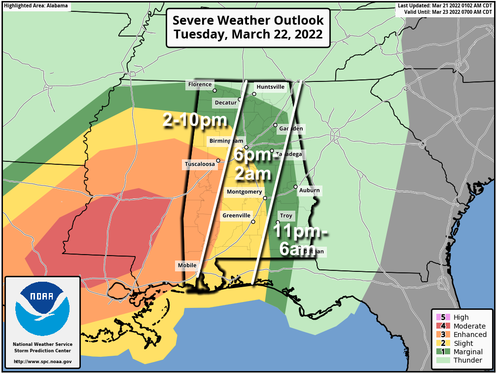
SPC has maintains an “enhanced risk” (level 3/5) of severe thunderstorms in the broad area from Tuscaloosa to Mobile, a “slight risk” as far east as Hamilton, Birmingham, Montgomery, and Luverne, and a “slight risk” (level 1/5) over to Huntsville, Anniston, and Ozark.
Dynamics will be impressive with this system, and the overall pattern is favorable for severe thunderstorms, especially over the western half of the state.
TIMING: Storms could enter West Alabama as early as 2:00 p.m. tomorrow; the risk begins for the I-65 corridor (places like Birmingham) around 6:00 p.m., and then over the eastern third of the state after 11:00 p.m.
THREATS: All modes of severe weather will be possible, including large hail, damaging wind, and a few tornadoes. The highest tornado threat is across the “enhanced risk” over West and Southwest Alabama, where a strong tornado (EF-2 or higher) will be possible.
WIND: Gradient winds (not related to thunderstorms) could gust as high as 35/40 mph across the state tomorrow afternoon and tomorrow night. A wind advisory has been issued.
RAIN: Rain amounts of 2-3″ are likely over the western half of the state, with 1-2″ for the eastern counties. A flood watch is in effect for parts of West and Central Alabama, including places like Birmingham and Tuscaloosa.
PREPARE: Be sure you have a reliable way of hearing severe weather warnings (NEVER a siren); a NOAA Weather Radio is the baseline. On your phone, be sure emergency alerts are enabled, and have the free ABC 33/40 weather app installed. Know the safe place in your home, and in that safe place have helmets for everyone. If you live in a mobile home, know where you are going (community shelter, business, etc), and have transportation.
REMEMBER: Don’t be anxious or worried; events like this are very common in Alabama during our tornado season, especially March and April. Have a way of hearing warnings, have a plan, and you will be fine. Odds of any one spot being hit by a tornado are low, but we all have to be ready.
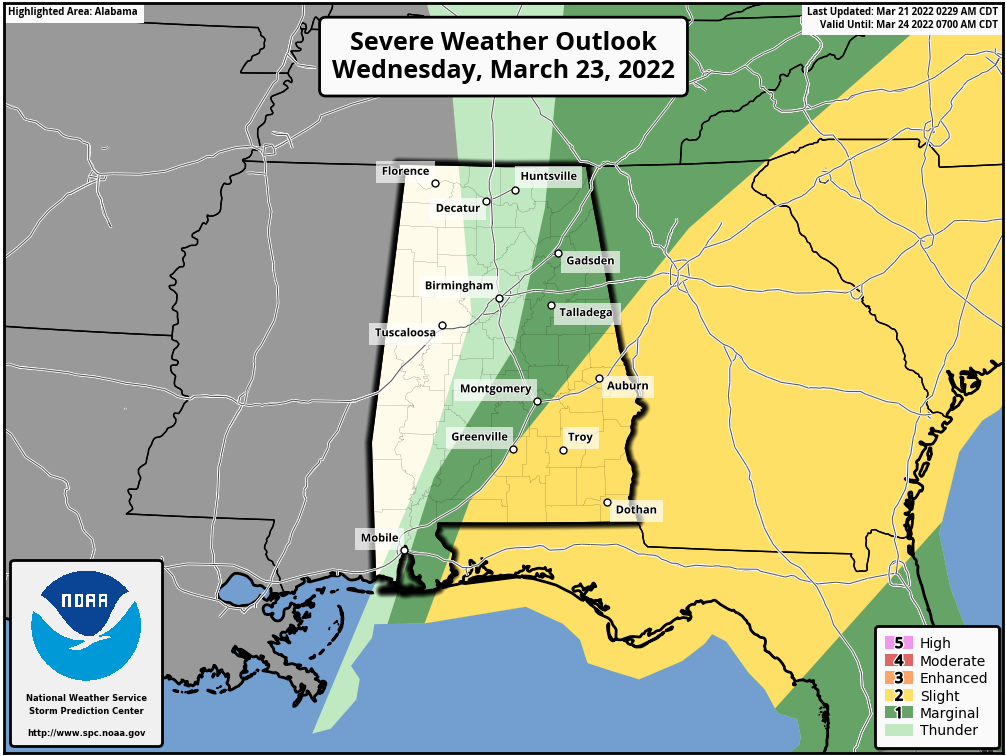
WEDNESDAY: Strong to severe storms could linger into Wednesday morning over the southeast part of Alabama, where SPC has a “slight risk” (level 2/5) defined. The main concern for Southeast Alabama will be strong winds, although an isolated tornado can’t be ruled out. For the rest of the state, some clearing is possible by afternoon with a high between 68 and 72 degrees.
THURSDAY THROUGH THE WEEKEND: Thursday and Friday will be dry with partly sunny days along temperatures a little below average; highs will be in the mid 60s. Then, over the weekend, we expect lots of sunshine with highs in the low 60s Saturday, followed by mid 60s Sunday. Sunday morning will be cold with lows in the 30-38 degree range… frost is likely, and colder spots will see another late season freeze. Growers beware.
NEXT WEEK: Much of next week looks dry with temperatures returning to the 70s; rain and storms will likely return toward the end of the week, Thursday or Friday. See the Weather Xtreme video for maps, graphics, and more details.
ON THIS DATE IN 1932: A generational tornado outbreak for Alabama. At least two dozen tornadoes touched down, but we won’t know the exact number. Official Weather Bureau tabulations said that 268 persons were killed in Alabama with 1874 injured, but those numbers are most likely too low.
It was around 3:30 in the afternoon on that fateful Monday when the first tornadoes came pounding to the ground in the Demopolis, Linden, Faunsdale areas of West/Central Alabama. Death came to 36 persons in Marengo County, 136 were injured and 180 homes were destroyed. Then came the disaster at Tuscaloosa and Northport, where 38 persons died in Northport and 250 were injured. Druid City Hospital in Tuscaloosa was quickly filled to capacity. The University of Alabama gymnasium was pressed into service as an emergency additional hospital.
Only one hour later, still more disaster. A path of destruction 20 miles long was cut across Cullman County. It left 23 dead and 300 injured. The Fairview community was hardest hit. The tragic day continued to unfold. Tornadoes struck in Alabama from 3:30 in the afternoon to at least 7:00 in the evening. A broad area received severe damage generally from Demopolis on the SW to Scottsboro, Stevenson and Paint Rock in NE Alabama and also eastward to Chilton, Coosa and Clay Counties.
Chilton County in Central Alabama was hit extremely hard with 58 persons killed. The Union Grove community near Jemison was laid to waste. Doctors and nurses from Montgomery and Birmingham worked all night by lantern and flashlight to relieve the widespead suffering. In Clay County, one of the tornadoes remained on the ground for 30 miles cutting a path 400 yards wide. Alabama Governor B. M. Miller immediately issued a proclamation calling on all Alabama residents to rise to the occasion and help those in distress. Then he traveled the state for days in his T-Model Ford trying to visit all of the damaged areas to offer help and encouragement.
BEACH FORECAST: Click here to see the AlabamaWx Beach Forecast Center page.
WEATHER BRAINS: Don’t forget you can listen to our weekly 90 minute show anytime on your favorite podcast app. This is the show all about weather featuring many familiar voices, including our meteorologists here at ABC 33/40.
CONNECT: You can find me on all of the major social networks…
Look for the next Weather Xtreme video here by 6:00 a.m. tomorrow…
Category: Alabama's Weather, ALL POSTS, Weather Xtreme Videos
About the Author (Author Profile)
James Spann is one of the most recognized and trusted television meteorologists in the industry. He holds the AMS CCM designation and television seals from the AMS and NWA. He is a past winner of the Broadcast Meteorologist of the Year from both professional organizations.Subscribe
If you enjoyed this article, subscribe to receive more just like it.


