Sun, Heat, Scattered Storms
RADAR CHECK: As expected, we have scattered, random showers and thunderstorms across Alabama this afternoon. Stronger storms are producing heavy rain, gusty winds, and lots of lightning. Otherwise, we have a mix of sun and clouds this afternoon with temperatures mostly in the 84-89 degree range. Scattered storms will fade after the sun sets this evening.
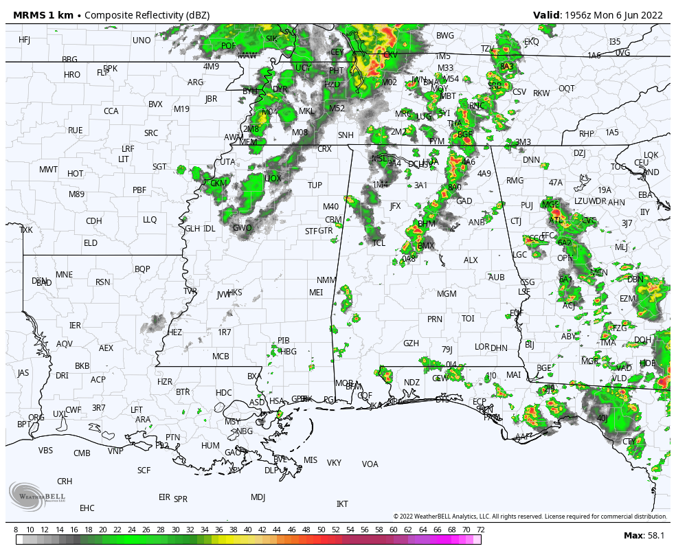
REST OF THE WEEK: Not much change. Each day look for partly sunny, hot, humid conditions with scattered to numerous, mostly afternoon and evening showers and thunderstorms. Chance of any one particular spot getting wet daily is in the 50-60 percent range, and most of the storms will come from about 2:00 until 10:00 p.m… but a late night or morning shower can’t be ruled out. We SPC has much of North Alabama in a “marginal risk” (level 1/5) of severe thunderstorms tomorrow and Wednesday with the potential of hail and strong winds with heavier storms.
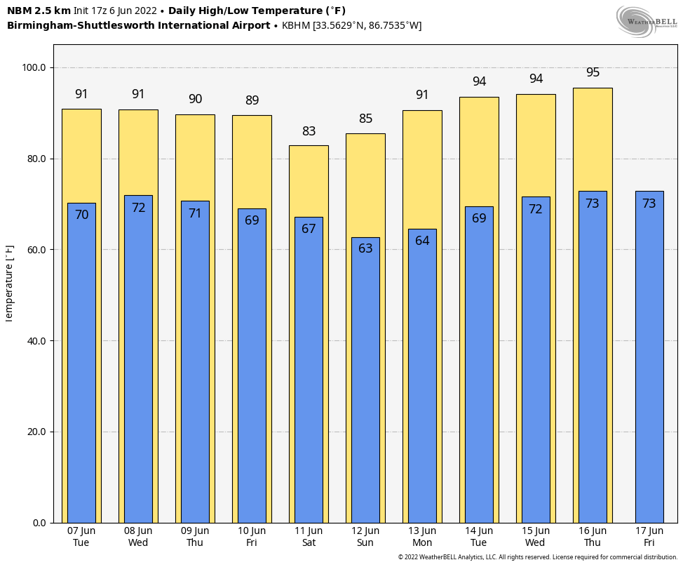
Afternoon highs will be in the mid to upper 80s most days.
THE ALABAMA WEEKEND: Same situation Saturday; cloudy periods with a chance of showers and thunderstorms. Not an all day rain, but a decent chance most places will see at least a passing shower. Then, global models continue to suggest a nice surge of drier air will arrive Sunday, meaning a mostly sunny day and lower humidity levels. Highs will remain in the 80s over the weekend.
NEXT WEEK: An upper ridge will build over the region, meaning higher heat levels, with potential for mid 90s on a few days over the latter half of the week. Otherwise, expect partly sunny days with a few widely scattered afternoon and evening thunderstorms. See the Weather Xtreme video for maps, graphics, and more details.
TROPICS: Alex has lost tropical characteristics in the Atlantic northeast of Bermuda, and the rest of the Atlantic basin (including the Gulf of Mexico) is very quiet.
RAIN UPDATE: Here are rain totals since January 1, and the departure from average…
Huntsville 32.07″ (+6.41″)
Birmingham 31.27″ (+4.87″)
Tuscaloosa 30.40″ (+5.91″)
Muscle Shoals 28.79″ (+4.00″)
Montgomery 26.24″ (+3.00″)
Anniston 26.23″ (+1.46″)
Mobile 24.65″ (-3.07″)
Dothan 24.46″ (+1.68″)
ON THIS DATE IN 1894: One of the greatest floods in U.S. history occurred as the Willamette River overflowed to inundate half of the business district of Portland, Oregon. The river crested at 33.5 feet, the worst flood ever recorded in the city.
BEACH FORECAST: Click here to see the AlabamaWx Beach Forecast Center page.
WEATHER BRAINS: Don’t forget you can listen to our weekly weather show all about weather anytime on your favorite podcast app. James Spann and a team of meteorologists from around the nation bring on interesting guests; a great podcast for weather geeks/dweebs/weenies.
CONNECT: You can find me on all of the major social networks…
Look for the next Weather Xtreme video here by 6:00 a.m. tomorrow…
Category: Alabama's Weather, ALL POSTS, Weather Xtreme Videos
About the Author (Author Profile)
James Spann is one of the most recognized and trusted television meteorologists in the industry. He holds the AMS CCM designation and television seals from the AMS and NWA. He is a past winner of the Broadcast Meteorologist of the Year from both professional organizations.Subscribe
If you enjoyed this article, subscribe to receive more just like it.


