New Day; Old Forecast For Alabama
HUMID SUMMER DAYS WITH SUN AND STORMS: Our classic summer weather pattern will continue across Alabama through the Fourth of July holiday weekend. Humid days with a mix of sun and clouds, and random, scattered showers and thunderstorms. It won’t rain everywhere each day, but where storms do form, they will be slow movers with potential for heavy rain, gusty winds, and very frequent lightning. Most, but not necessarily all, of the showers and storms will come from around 2:00 until 10:00 p.m. The chance of any one given point seeing rain each day will remain in the 45-55 percent range statewide.
Needless to say, there are many outdoor events planned for the weekend. With summer storms, nobody knows exactly when and where they pop up in advance… you just to watch radar trends once they form. And remember, if there is lightning within 8 miles, everyone needs to go indoors (or into a vehicle). When thunder roars, get indoors!
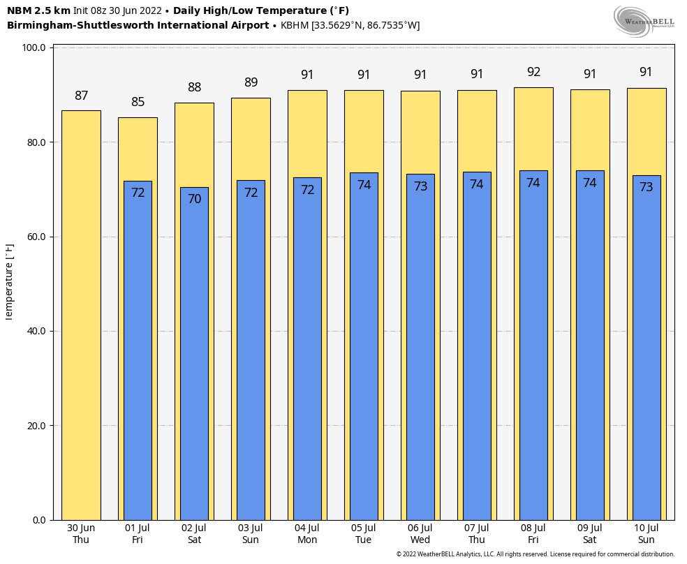
Temperatures will remain at or slightly below average levels with highs in the 86-91 degree range through Monday.
REST OF NEXT WEEK: The overall pattern won’t change much through the week. Partly sunny, hot, humid days with “scattered, mostly afternoon and evening showers and thunderstorms” around. Highs will be mostly in the low 90s. See the daily Weather Briefing video for maps, graphics, and more details.
TROPICS: Shower and thunderstorm activity remains poorly organized with an area of low pressure located over the western Gulf of Mexico. This system is forecast to move slowly westward and approach the coast of southern Texas and northern Mexico later today. Some slow development is still possible, and it could still become a short-lived tropical depression near the coast before it turns northwestward and moves inland over Texas later today. Regardless of development, heavy rain will be possible along portions of the Texas coast for the next few days. This feature will remain far west of Alabama and the Central Gulf Coast.
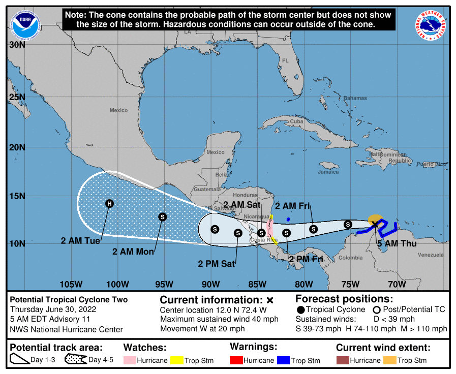
“Potential Tropical Cyclone Two” is expected to become Tropical Storm Bonnie later today in the far Southwest Caribbean… it will move into Central America late tomorrow. This system is far south of the U.S.
Elsewhere, a tropical wave located over the western tropical Atlantic continues to produce disorganized showers and thunderstorms. Only slight additional development of this system is anticipated while it moves west-northwestward for the next several days. The wave is forecast to move over the Windward Islands late tomorrow or early Saturday and then over the eastern Caribbean Sea by the weekend, where further development is unlikely due to unfavorable environmental conditions. NHC gives this only a 10 percent of development over the next five days.
ON THIS DATE IN 1912: An estimated F4 tornado ripped through Regina, Saskatchewan, Canada on this day. The storm became the deadliest tornado in Canada’s history as it killed 28 people along a rare, 18.5-mile track from south to north.
ON THIS DATE IN 1999: Mount Baker, Washington closed out a record snowfall season both for the United States and the verifiable world record as the seasonal total from July 1, 1998, to June 30, 1999, finished with 1,140 inches.
BEACH FORECAST: Click here to see the AlabamaWx Beach Forecast Center page.
Look for the next Weather Xtreme video here by 3:00 this afternoon… enjoy the day!
Category: Alabama's Weather, ALL POSTS, Weather Xtreme Videos
About the Author (Author Profile)
James Spann is one of the most recognized and trusted television meteorologists in the industry. He holds the AMS CCM designation and television seals from the AMS and NWA. He is a past winner of the Broadcast Meteorologist of the Year from both professional organizations.Subscribe
If you enjoyed this article, subscribe to receive more just like it.


