Mix Of Sun And Scattered Storms Through The Weekend
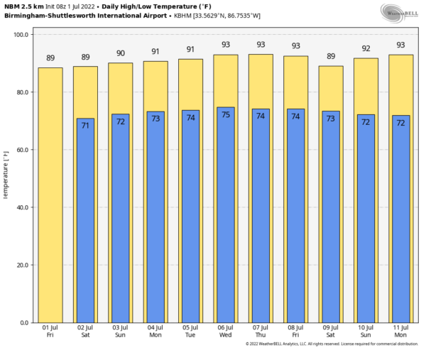
WELCOME TO JULY: We begin the second month of meteorological summer with the usual mix of sun and scattered thunderstorms across Alabama and the Deep South through the holiday weekend. Look for partly sunny days with highs in the 86-90 degree range. Random, scattered showers and storms will form mainly during the afternoon and evening hours, from roughly 2:00 until 10:00 p.m. We just can’t tell you in advance exactly when and where the storms fire up; for outdoor events just keep a close eye on radar trends. With light winds aloft, the storms that form won’t move much, and they can drop lots of rain in a short period of time, and strong, gusty winds can develop. The chance of any one location seeing a storm is 45-55 percent through Sunday, and 30-40 percent Monday.
REST OF NEXT WEEK: The upper ridge will be a bit stronger across the Deep South, meaning heat levels will rise a bit with highs mostly in the low 90s next week. Afternoon showers and storms remain possible, but they should be more widely scattered. See the daily Weather Briefing video for maps, graphics, and more details.
TROPICS: The tropical wave that has been over the far western Gulf of Mexico has moved into Texas and won’t develop. Heavy rain is possible across far Southwest Texas and Southwest Louisiana, where flash flood watches are in effect this morning.
“Potential Tropical Cyclone Two” in the far Southwest Caribbean is still expected to become Tropical Storm Bonnie today, moving into Central America tonight. And, a weak wave is approaching the Windward Islands, but is is not expected to develop due to harsh environmental conditions. The rest of the Atlantic basin is very quiet, and there are no tropical systems threatening the Central Gulf Coast (Gulf Shores to Panama City Beach) anytime soon.
RAIN UPDATE: Here are rain totals since January 1, and the departure from average…
Birmingham 40.21″ (+9.80″)
Huntsville 33.78″ (+4.70″)
Tuscaloosa 33.65″ (+5.18″)
Montgomery 29.61″ (+2.93″)
Anniston 29.51″ (+1.07″)
Muscle Shoals 29.20″ (+0.16″)
Dothan 28.67″ (+1.58″)
Mobile 27.89″ (-5.33″)
ON THIS DATE IN 2002: San Antonio, Texas recorded 9.52 inches of rain on this day to set a new record for its greatest rainfall for the entire month of July.
BEACH FORECAST: Click here to see the AlabamaWx Beach Forecast Center page.
Look for the next Weather Briefing Video here by 3:00 this afternoon… enjoy the day!
Category: Alabama's Weather, ALL POSTS, Weather Xtreme Videos


