Trending Drier Tomorrow And Over The Weekend
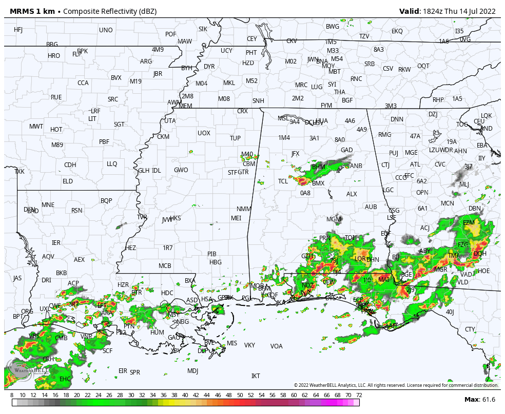
RADAR CHECK: There are a few scattered showers across North/Central Alabama this afternoon; parts of the Birmingham metro had a decent downpour earlier today with a cluster of slow moving storms.But, the more widespread rain is over the southern half of the state, where moisture levels are higher. Away from the showers, the sky is partly sunny with temperatures mostly in the 86-91 degree range.
Showers across Alabama will fade tonight after sunset.
TOMORROW AND THE WEEKEND: The weather will trend drier; the chance of a shower will be small over the northern half of the state, and showers and storms over South Alabama should be widely scattered. Expect partly sunny days with highs mostly in the low 90s, right at seasonal averages for mid-July in Alabama.
NEXT WEEK: Looks like a classic summer pattern next week with highs in the 90-94 degree range most days along with the chance of a few random, scattered showers or storms during the afternoon and evening hours. Otherwise, partly sunny days and mostly fair nights… See the daily Weather Briefing video for maps, graphics, and more details.
SUMMER SOAKERS THIS MORNING: A band of nearly stationary rain and strong storms setup this morning in a broad zone from Montgomery to Auburn… some spots received 4 inches of rain based on radar estimates, and flash flood warnings were required for several counties.
TROPICS: All remains very quiet across the Atlantic basin, and tropical storm formation is not expected through next week. The next names on the list this year are Danielle, Earl, and Fiona.
ON THIS DATE IN 1995: Thunderstorms producing severe weather were occurring over Upper Michigan and adjacent portions of Ontario near Sault Saint Marie. By late evening the storms had evolved into a bowing line just northwest of the Mackinac Bridge. At 10:17 PM EDT, the thunderstorm gust front hit the bridge, and a gust to 90 mph was measured. Sustained winds of 80 mph continued on the bridge for ten more minutes. Thus began the intense “Ontario-Adirondacks Derecho” that would cause hundreds of millions of dollars’ worth of damage, several deaths, and many injuries as it raced southeast from the northern Great Lakes to the Atlantic coast.
BEACH FORECAST: Click here to see the AlabamaWx Beach Forecast Center page.
Look for the next Weather Xtreme video here by 6:00 a.m. tomorrow…
Category: Alabama's Weather, ALL POSTS, Weather Xtreme Videos
About the Author (Author Profile)
James Spann is one of the most recognized and trusted television meteorologists in the industry. He holds the AMS CCM designation and television seals from the AMS and NWA. He is a past winner of the Broadcast Meteorologist of the Year from both professional organizations.Subscribe
If you enjoyed this article, subscribe to receive more just like it.


