Showers/Storms Later Today; Dry Air Arrives This Weekend
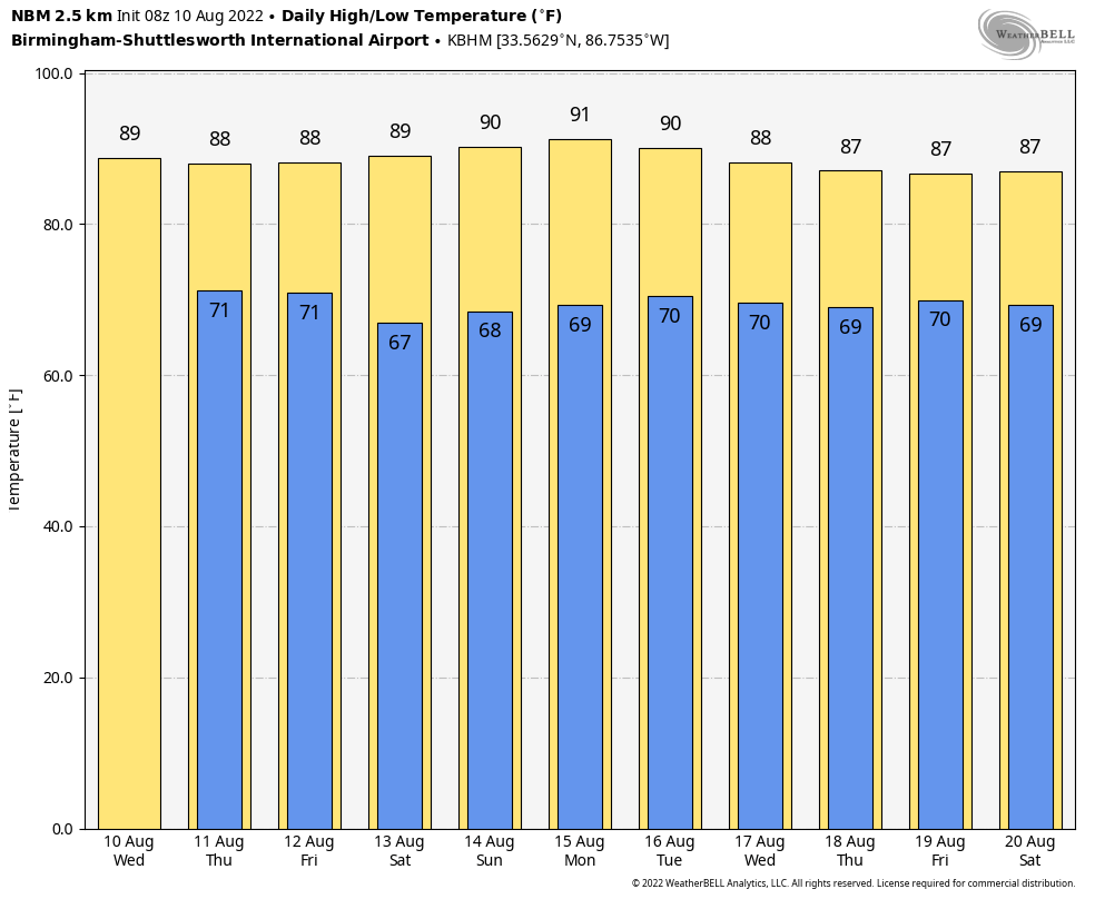
MUGGY, SOUPY AIR: Showers are few and far between on radar early this morning, but they become numerous across the state later today and early tonight, mostly between noon and midnight in the ocean of humidity that covers the Deep South. Like recent days, storms that form will be slow movers, and the stronger ones will produce heavy rain, strong gusty winds, some small hail, and lots of lightning. The high today will be in the 87-91 degree range.
Don’t expect much change tomorrow, but on Friday dry air begins to move into the northern half of the state; most of the showers and storms will develop over the southern counties.
THE ALABAMA WEEKEND: Unusually dry air for August will cover most of the state, and we expect sunny days, fair pleasant nights, and slightly lower humidity levels. There might be an isolated shower or two near the Gulf Coast, but even there it will be mostly dry. Highs will be close to 90, with lows in the 60s. Some of the cooler spots over North Alabama could dip into the low 60s Saturday and Sunday morning.
NEXT WEEK: The weather still looks dry Monday, but moisture levels rise Tuesday, and we will bring back the chance of scattered showers and storms by afternoon. Then, fairly typical summer weather continues over the latter half of the week with partly sunny days and the risk of a pop-up afternoon storm in spots. Highs will be in the 87-90 degree range, which is below average for mid-August. See the daily Weather Briefing video for maps, graphics, and more details.
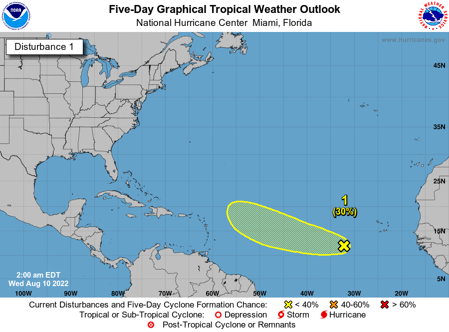
TROPICS: A tropical wave located several hundred miles west-southwest of the Cabo Verde Islands continues to produce disorganized showers and
thunderstorms. Some gradual development of this system is possible over the next few days. However, environmental conditions are forecast to become less favorable by this weekend. This system is expected to move westward to west-northwestward at 15 to 20 mph across the tropical Atlantic during the next several days.
NHC gives it a 30 percent chance of development over the next five days… if anything happens to form it should turn northward well before reaching the U.S. The rest of the Atlantic basin is very quiet.
ON THIS DATE IN 1856: A hurricane destroyed Isle Dernieres or Last Island, a pleasure resort south-southwest of New Orleans on this day. The highest points of the island were under five feet of water. The resort hotel was destroyed, along with the island’s gambling establishments. Over 200 people perished, and the island lost all its vegetation and split in half. Only one cow remained on the island after the catastrophe. The Last Island is now just a haven for pelicans and other seabirds. The steamer Nautilus foundered during the storm. The lone survivor clung to a bale of cotton and washed ashore sometime later.
ON THIS DATE IN 1980: Hurricane Allen made landfall just north of Brownsville, Texas. The hurricane achieved Category 5 status three separate times (the only Atlantic hurricane to do so). It also ranks as one of the most powerful Atlantic hurricanes with sustained winds near 190 mph at its peak. When Allen made landfall, it had weakened to a Category 3 storm. Still, it brought damaging winds and torrential rainfall. The remnants of the storm caused a brief lapse in the heat wave of 1980 in places like Dallas/Fort Worth, Texas, which had recorded 69 days of 100 degree heat.
BEACH FORECAST: Click here to see the AlabamaWx Beach Forecast Center page.
Look for the next Weather Xtreme video here by 3:00 this afternoon… enjoy the day!
Category: Alabama's Weather, ALL POSTS, Weather Xtreme Videos
About the Author (Author Profile)
James Spann is one of the most recognized and trusted television meteorologists in the industry. He holds the AMS CCM designation and television seals from the AMS and NWA. He is a past winner of the Broadcast Meteorologist of the Year from both professional organizations.Subscribe
If you enjoyed this article, subscribe to receive more just like it.


