Warm/Dry Through Tomorrow; Showers Return Saturday
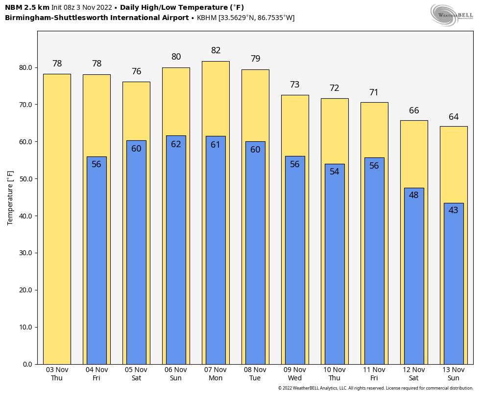
BIG WARM-UP: We are starting off the day with a clear sky along with temperatures in the 40s and 50s. But expect a big warm-up today… the high will be around 80 degrees, which is eleven degrees above average (today’s average high at Birmingham is 69), and not too far from the record high of 84, last set in 2016. No change tomorrow… another sunny day with a high around 80 degrees.
THE ALABAMA WEEKEND: Clouds increase tomorrow night, and a weakening band of showers will push into West and North Alabama Saturday morning ahead of a surface front. A rumble of thunder is not totally out of the question, but there is no risk of severe storms. Showers will weaken and fade as they try and push into East Alabama during the afternoon and evening hours; in fact most of Saturday night should be dry. Saturday will be mostly cloudy with a high in the upper 70s.
The front will wash out Sunday, but there will be some risk of scattered showers statewide. Nothing widespread or heavy… otherwise Sunday will feature a mix of sun and clouds with a high in the 77-80 degree range as the warm November weather continues.
NEXT WEEK: The first half of the week will be generally dry and mild with highs in the 70s. There is some evidence rain is possible over the eastern half of the state late in the week in response to a disturbance over the northeast Gulf of Mexico. A cold front will bring a chance of showers statewide by Friday or Friday night, followed by much cooler air over the following weekend (November 12-13)… See the daily Weather Briefing video for maps, graphics, and more details.
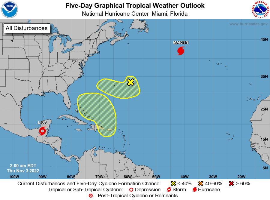
TROPICS: Tropical Storm Lisa is weakening rapidly over Mexico this morning; the remnant circulation will emerge into the Bay of Campeche by tonight, and it is expected to dissipate by Saturday. And, in the North Atlantic, Hurricane Martin will become an extratropical, large, cold core North Atlantic storm over the next 24 hours.
Elsewhere, a non-tropical, but complex area of low pressure is expected to develop this weekend over the northeastern Caribbean Sea or the southwestern Atlantic. Some slow subtropical or tropical development of this system is possible afterward while it moves generally northward to northwestward through early next week.
FOOTBALL WEATHER: The sky will be mostly fair tomorrow night for the high school playoff games; temperatures will fall from the low 70s at kickoff, into the upper 60s by the final whistle.
UAB will host UTSA Saturday at Protective Stadium in downtown Birmingham (2:30p CT kickoff)… the sky will be cloudy with a chance of showers during the game. Temperatures will be in the low to mid 70s.
Auburn will take on Mississippi State in Starkville Saturday evening (6:30p CT kickoff)… the sky will be cloudy; it looks like there is a decent chance the rain will end by kickoff… just an outside risk of a shower during the first half. Temperatures will be in the low 70s at kickoff, and in the upper 60s by the final whistle.
And, Alabama will be in Baton Rouge to play LSU in “Death Valley” (6:00p CT kickoff)… the sky will be cloudy with a lingering shower possible during the first quarter, but like the situation in Starkville it looks like most of the widespread rain will be over by kickoff. Temperatures will be close to 70 degrees during the game.
We note that is rain is likely in both Starkville and Baton Rouge during the day Saturday before the games. Not raining all day, but occasional rain with potential for some thunder.
ON THIS DATE IN 1966: An early season snowfall for Alabama, which started on the 2nd… the winter storm whitened the ground from Alabama to Michigan. Mobile had their earliest snowflakes on record; Huntsville had 4 inches of snow.. Louisville, Kentucky measured 13.1 inches, Nashville; Tennessee reported 7.2 inches.
ON THIE DATE IN 2007: Dense fog in the early morning hours resulted in a 100 vehicle pile-up just north of Fowler, CA on I-99. Two people were killed, and 41 others were injured. The thick seasonal fog is known as “Tule fog” and typically occurs in Central California in late fall and winter.
BEACH FORECAST: Click here to see the AlabamaWx Beach Forecast Center page.
Look for the next Weather Briefing video here by 3:00 this afternoon… enjoy the day!
Category: Alabama's Weather, ALL POSTS, Weather Xtreme Videos
About the Author (Author Profile)
James Spann is one of the most recognized and trusted television meteorologists in the industry. He holds the AMS CCM designation and television seals from the AMS and NWA. He is a past winner of the Broadcast Meteorologist of the Year from both professional organizations.Subscribe
If you enjoyed this article, subscribe to receive more just like it.


