Warm Weather Continues; Showers Over North Alabama
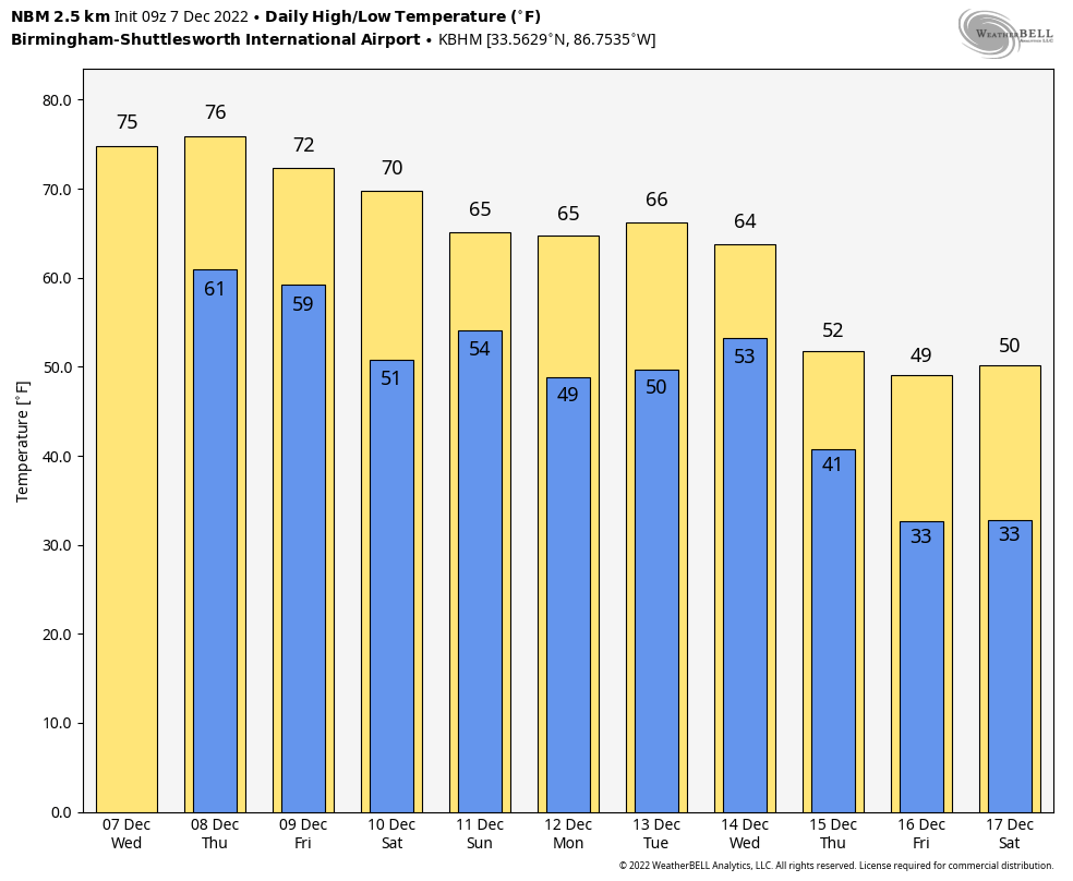
RADAR CHECK: Scattered showers continue across the northern 2/3 of Alabama early this morning… the more numerous ones are over the Tennessee Valley. A few showers will remain possible through the day today, but the big story is the December warmth. The high this afternoon will be in the mid 70s in most places, about 15 degrees above average. Highs remain in the 70s through Friday, not far from record levels.
Here are the record highs for Birmingham… not expecting to break them, but it will be close.
December 7 (today) 80, set in 1951
December 8 (Thursday) 79, set in 1978
December 9 (Friday) 74, set in 1946
Tomorrow will be mostly dry with just a few showers near the Tennessee border. We will mention a risk of showers Friday as a surface front approaches, but the rain’t be especially heavy or widespread.
THE ALABAMA WEEKEND: The front will have a hard time pushing through Alabama… it likely becomes stationary. Meaning a mostly cloudy weekend with some potential for rain at times both days. No washout, and no risk of severe storms. For now it looks like the higher coverage of rain will come on Sunday; highs over the weekend will be in the 66-73 degree range.
NEXT WEEK: Warm weather continues Monday and Tuesday; there will be a few scattered showers around both days, but nothing widespread. To the west, SPC has defined a risk of severe storms from North Texas and Oklahoma to Arkansas, Louisiana, and parts of Mississippi early in the week, but they do not have Alabama in a risk at this point at mid-week. The system arrives here Wednesday with rain and thunderstorms… the best dynamic support will stay well to the north, and instability values look low. So, for now the severe weather threat in Alabama looks very limited, but understand this is a week out, and things could change. Colder, drier air returns Thursday and Friday with highs in the 50s and lows in the 30s.
Global models continue to show signals for a colder look for the Deep South by Christmas and late December… See the daily Weather Briefing video for maps, graphics, and more details.
TROPICS: A large non-tropical area of low pressure located over the central subtropical Atlantic about 800 miles northeast of the northern Leeward Islands continues to produce a large area of disorganized showers and thunderstorms. Environmental conditions appear marginally conducive for development and a subtropical or tropical storm could form within the next day or two. By tomorrow night or early Friday, the low will move northeastward over cooler waters and interact with a mid-latitude trough, limiting the chance for additional subtropical or tropical development of the system. It will remain far from land.
ON THIS DATE IN 2004: An F2 tornado tracked for eight miles across parts of rural Lowndes County, MS, and into Lamar County, AL. The worst damage occurred near Steens, MS, where several homes were ripped apart, a trailer was destroyed, and numerous trees were knocked over.
ON THIS DATE IN 2006: A rare tornado tore through Kensal Rise in London. This T4 on the TORRO scale, equivalent to an F2 on the Fujita scale, injured six people and damaged 150 homes. According to the BBC, the last tornado which caused significant damage in London was in December 1954, in West London.
BEACH FORECAST: Click here to see the AlabamaWx Beach Forecast Center page.
Look for the next Weather Briefing video here by 3:00 this afternoon… enjoy the day!
Category: Alabama's Weather, ALL POSTS, Weather Xtreme Videos
About the Author (Author Profile)
James Spann is one of the most recognized and trusted television meteorologists in the industry. He holds the AMS CCM designation and television seals from the AMS and NWA. He is a past winner of the Broadcast Meteorologist of the Year from both professional organizations.Subscribe
If you enjoyed this article, subscribe to receive more just like it.


