Rain/Storms Tonight; Dry Air Returns Tomorrow
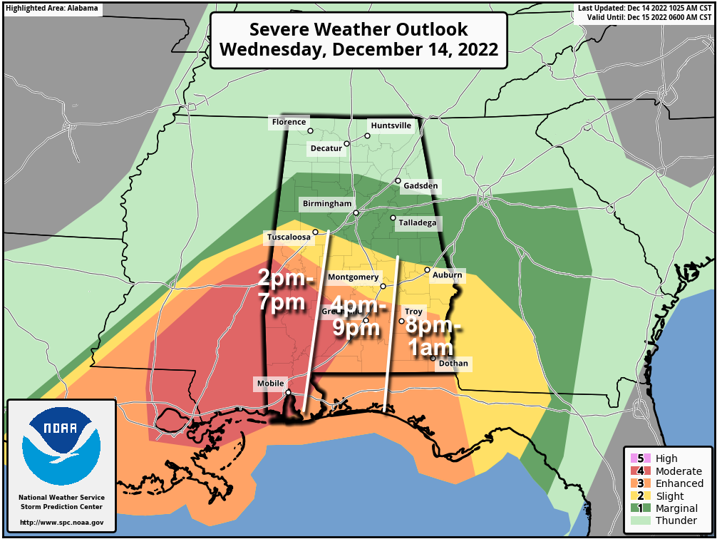
STORMY NIGHT: The dual threat of heavy rain and severe storms will continue across Alabama tonight. A flash flood watch remains in effect for the northern 2/3 of the state, and we now have a level 4/5 “moderate risk” of severe thunderstorms for the southwest counties of the state.
Some notes on the expected weather tonight:
*Forecast soundings show very strong low-level vertical shear and favorable deep-layer shear for tornadoes across Southwest Alabama, along with sufficient CAPE (instability) for robust thunderstorms.
*Low-level winds are expected to strengthen further during the afternoon with the approach of the upper trough. Tornadoes, including the possibility of strong and long-track tornadoes, are the primary concern in the moderate risk area.
*Some of the cities in the moderate risk include Mobile, Fairhope, Monroeville, Jackson, Grove Hill, Thomasville, Millry, Butler, Pine Hill, Linden, and York.
*Severe storms are not expected over North Alabama, where the air is cool and stable. But, a flash flood watch is in effect there.
*We will watch the northern extent of the unstable air (and accordingly, the northern edge of the severe weather threat) closely through the afternoon; for now it looks like it will remain south of Tuscaloosa, but it is a close call. Severe storms are unlikely for places like Birmingham, Anniston, Gadsden, Huntsville, and Florence.
*Be sure you can hear severe weather warnings if they are needed later today and tonight. A NOAA Weather Radio is the baseline for every home and business… and be sure WEA (Wireless Emergency Alerts) are enabled on your phone. Install the free ABC 33/40 Weather app. Know the safe place in your home (lowest floor, near the center of the house, away from windows), and have helmets for everyone there. If you live in a mobile home, know the location of the nearest shelter or site built structure that is available, how to get there quickly, and have transportation.
*This is a significant threat for Southwest Alabama, be sure your friends and relatives are aware of the situation, and are paying close attention to warnings.
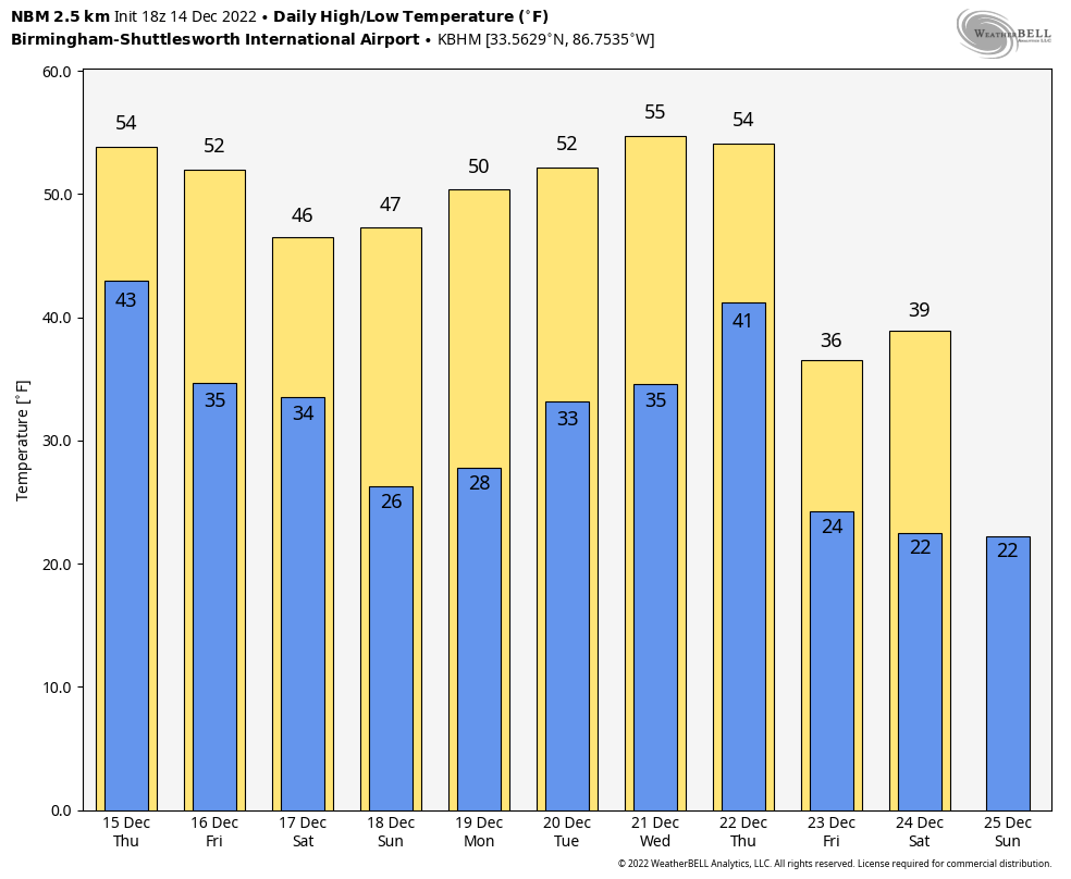
TOMORROW THROUGH THE WEEKEND: The weather will be dry and colder. The sky will be mostly sunny tomorrow and Friday with highs in the 50s. A disturbance will bring some clouds Saturday, any light rain will be confined to areas near the immediate Gulf Coast. Saturday’s high will be in the 47-53 degree range. Then, Sunday will be a sunny day with a high in the 40s over North Alabama, 50s for the southern counties. Temperatures drop into the 20s Sunday morning… for most places this will be the first freeze since December 1.
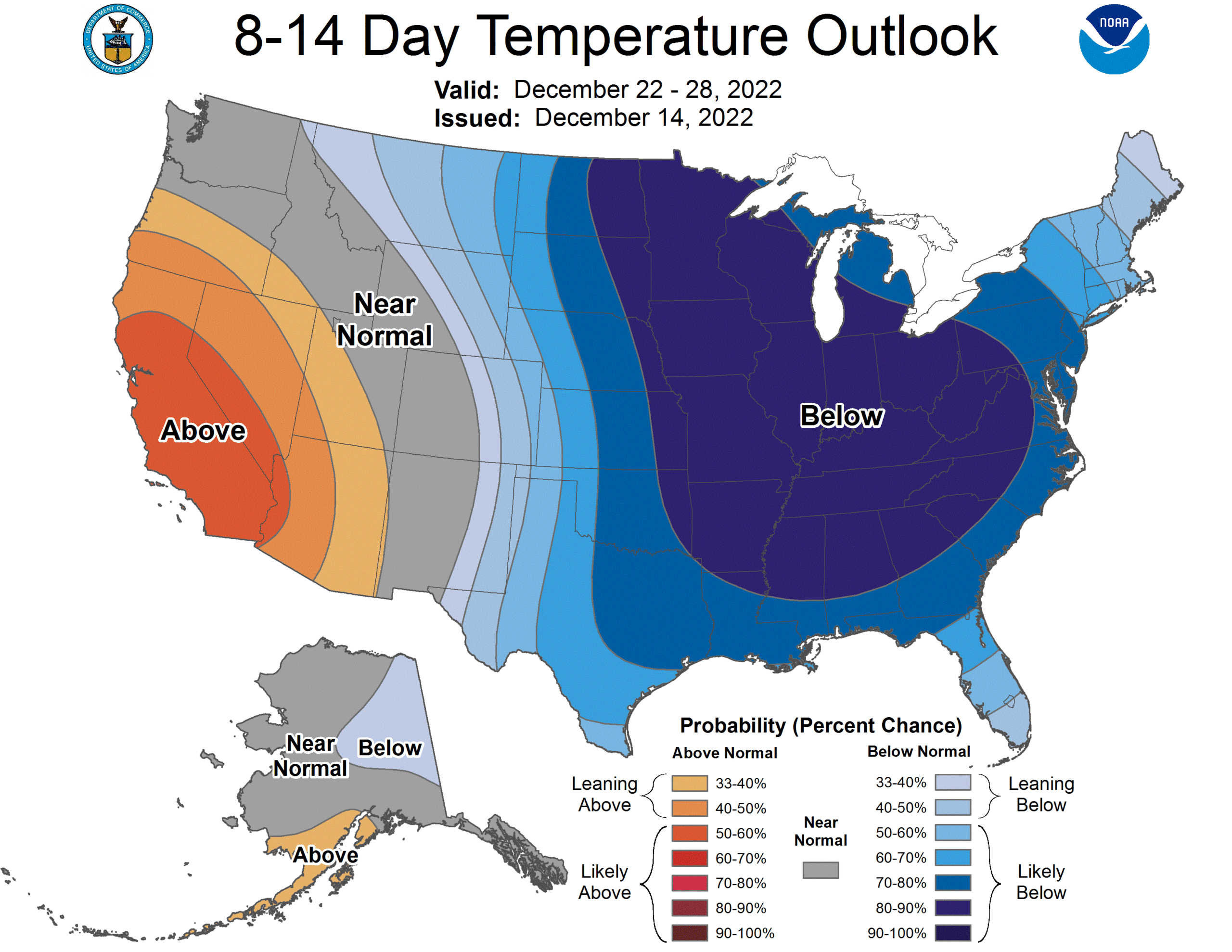
NEXT WEEK: For now the week looks dry with highs in the 40s and 50s, with lows around freezing each morning. Very cold, Arctic air will likely roll into Alabama late in the week and over the Christmas weekend; this is the type airmass that could bring sub-freezing temperatures to Alabama for around 72 consecutive hours, and push lows into the single digits in spots over the northern counties. We will be much more specific about this cold wave in coming days… See the daily Weather Briefing video for maps, graphics, and more details.
ON THIS DATE IN 1952: Trace of snow or sleet at or near Pensacola, Crestview, DeFuniak Springs, Quincy, Carrabelle, Tallahassee, St. Marks, Monticello, Madison, Mayo, Live Oak, Lake City, Glen St. Mary, and Hilliard in Florida. Frozen precipitation occurred before noon at most points, but happened in the afternoon at Mayo and Lake City and near Hilliard. Temperatures were above freezing and snow or sleet melted as it fell.
ON THIS DATE IN 1997: A cold core upper low brought an unexpected band of heavy snow to parts of West-Central Alabama… parts of Choctaw, Sumter, Greene, Hale, and Marengo counties experienced over 6 inches of snow when a cold rain was forecast. In Mississippi, this was one of the heavier snowfalls to occur since 1929. The weight of the snow caused limbs of trees to break, which knocked down power lines.
BEACH FORECAST: Click here to see the AlabamaWx Beach Forecast Center page.
Look for the next Weather Briefing video here by
Category: Alabama's Weather, ALL POSTS, Weather Xtreme Videos
About the Author (Author Profile)
James Spann is one of the most recognized and trusted television meteorologists in the industry. He holds the AMS CCM designation and television seals from the AMS and NWA. He is a past winner of the Broadcast Meteorologist of the Year from both professional organizations.Subscribe
If you enjoyed this article, subscribe to receive more just like it.


